Tuesday, 24 December 2013
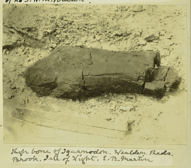
Iguanodon, Elephant, Bison, Rhinoceros and other saurian remains 1911.
Thigh bone of Iguanodon, Wealden Beds, Brook, Isle of Wight. E.T. Martin.
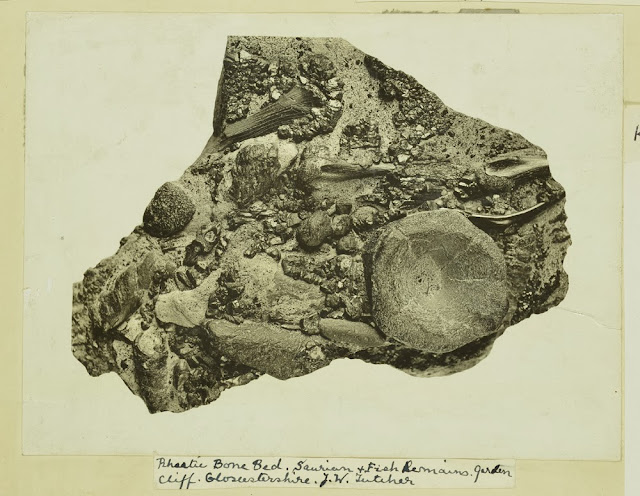
Rhaetic Bone Bed. saurian and fish remains. Garden Cliff. Gloucestershire. J.W. Fletcher.
Elephant and Rhinoceros. Barrington Beds. Cambridgeshire. H.M. Krusin 15.6.1911
Bison, Elephant and Rhinoceros, Barrington Beds. Barrington Cambridgeshire 15.6.1911
Images from the Geologists' Association 'Carreck Archive' held at the British Geological Survey
Bob McIntosh
Saturday, 21 December 2013
Searching for Palaeolithic implements, Milton Street Gravel Pits, Kent. 1908.
Caption: Workmen with rods for searching for Palaeolithic implements, Milton Street Gravel Pits, Kent. T.W. Reader 23.5.08. [1908]
Caption: Some members examining the Flint Implement collection of Mr. Treacher. [Llewellyn Treacher] T.R.W. 25.6.10 [1910]
Photographs are from the Geologists' Association 'Carreck Archive' on deposit at the British Geological Survey.
Bob McIntosh
Tuesday, 10 December 2013
Christmas card from J V Harrison, 1930
 |
| BGS image ID: P700432 |
 |
| BGS image ID: P700433 |
 |
| BGS image ID: P700434 |
This Christmas card from J V Harrison shows Aiuuk Bivouack in the Bakht-i-ari mountains of Persia (now Iran).
John Vernon Harrison was born on 16 March 1892. He graduated with a BSc with distinctions in Chemistry and Geology from the University of Glasgow in 1914. In 1916-1918 he served with the Royal Engineers in Mesopotamia. In 1918 he joined the geological staff of the Anglo Persian Oil Company. He carried out field work in Persia and Iraq (1918-1920) and then travelled to many places including Honduras (1920-1922), United States and Mexico (1922-1923), North Borneo, Hong Kong, Japan and Canada (1924), Peru (1924-1925), Jamaica (1925), Venezuela (1925-1926), Trinidad (1926-1927) and Colombia (1927-1928). Much of his time after 1928 was spent in Persia until he was appointed Lecturer in Geology at Oxford University in 1938. Summer vacations allowed him to travel to the Peruvian Andes with some of his students. During World War II he was seconded to the Admiralty for geographical work. After the war he was appointed Reader in Structural Geology back at Oxford. He retired in 1959, was awarded the Lyell Medal in 1961and died on 31 July 1972
A catalogue of Harrison's collection at the British Gelogical Survey Archives can be accessed here
Andrew L Morrison

Monday, 9 December 2013
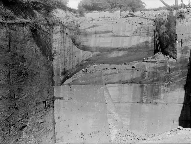
Ballochmyle Quarry, Mauchline. Ayrshire, 1921
 |
| BGS Image ID: P000071 |
Date of image: 1921.
 |
| BGS Image ID: P753273 |
Emily Tracey
Building Stones Conservation Specialist.
Visit the new building stones web pages
Friday, 6 December 2013
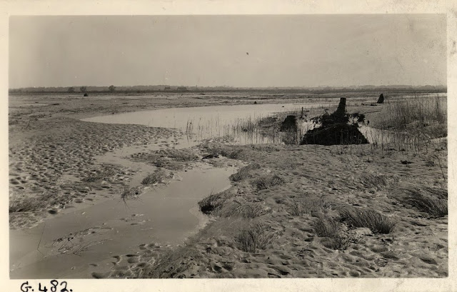
Horsey coastal inundation, Norfolk 1938.
 |
| BGS image ID: P256624 |
 |
| BGS image ID: P256625 |
 |
| BGS image ID: P256626 |
 |
| BGS image ID: P256627 |
'Village of Horsey again inundated' Newspaper article 1938.
Images taken by H. Ashley. From the British Association for the Advancement of Science photograph collection. The collection is on permanent deposit with the British Geological Survey.
Historical photographs are often valuable evidence when comparing geological processes over time.
Historical photographs are often valuable evidence when comparing geological processes over time.
Bob McIntosh
Monday, 2 December 2013
Cowbar Nab, Staithes, Yorkshire Coast, 1897
 |
| BGS Image ID: P243611 |
 |
| BGS Image ID: P243612 |
Cowbar Nab, Staithes, Yorkshire Coast. Jurassic Lias rocks for the headland. Photographs by W.J. Harrison, held in British Association for the Advancement of Science (BAAS) photographic print collection on deposit at the British Geological Survey.
Has there been any substantial change since this photograph was taken in 1897?
Bob McIntosh
Tuesday, 26 November 2013
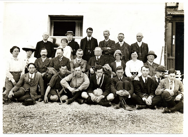
Group photograph of geologists on a trip to Sweden, Norway and Lapland 1909/1910
 |
| BGS image ID: P883132 |
Participants include John Horne, middle row, fourth from right (with moustache and prominent side-burns) Rachel Workman (later to become Lady Rachel MacRobert), middle row, third from right. Sir Alexander MacRobert is in the back row on the far right. Edward Battersby Bailey, front row, second from the right (with hat)
Rachel Workman and Sir Alexander MacRobert married in 1911.
The photograph was possibly taken before/after a trip to Sweden, Norway and Lapland in 1909/1910. The trip included a stay with the Emperor of Lapland as well as with Dr Lundbohm, originator of the Swedish Ironworks. Rachel Workman's diary also mentions a Mr. Bailey, a young Highland surveyor, we believe Bailey is front row, second from the right (with hat).
Places mentioned in Rachel Workman's diary are Narvik and the snow mountains of Torne Trask and Gellivare.
Many thanks to Vicky Duke of the The MacRobert Trust who supplied most of this information and the identification of Rachel Workman (Lady Rachel MacRobert).
Does any reader know any of the other participants or able to provide information about the background to the trip e.g. was the trip related to the 1910 International Geological Congress held in Sweden in 1910?
Bob McIntosh
Monday, 25 November 2013
Letter from Charles Darwin to Trenham Reeks
 |
| BGS image ID: P883129 |
 |
| BGS image ID: P883130 |
 |
| BGS image ID: P883131 |
This letter from Charles Darwin to Trenham Reeks was written on 13 August 1858 and concerns some slate reliefs that Darwin wanted to sell. The letter has been transcribed as part of the Darwin Correspondence Project and can be read here .
Andrew L Morrison
Sunday, 24 November 2013
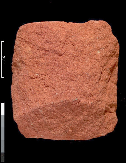
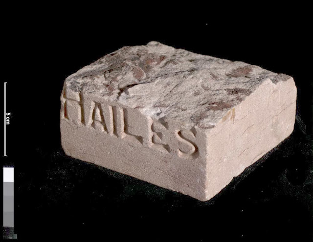
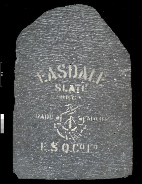
Three Scottish building stone specimens
 |
| BGS Image ID: P519461 |
Sample of red sandstone, showing uniform grainsize and colour. This specimen is of Devonian age. British Geological Survey Petrology Collection sample number MC2092. This sample is from an abandoned quarry which may have been used for local building stone. Red sandstone was commonly used in Scotland from the late 19th century. The largest and most significant quarries of red sandstone in Scotland were in Ayrshire and Dumfriesshire, from where the stone was transported by railway.
 |
| BGS Image ID: P519533 |
Oblique photograph of a specimen of Hailes sandstone, with the name of the quarry carved on one side. This specimen is of Carboniferous age. British Geological Survey Petrology Collection sample number MC1318. The upper surface has been left in its natural state, showing the uneven bedding surface. Such samples were prepared by the quarry in order to market the stone. This sample dates from before the First World War. Size of specimen: 11x11x5 cm. Munsell colour code and colour 5YR8/1, pinkish grey.
 |
| BGS Image ID: P519560 |
This slate shows the trade mark stamp of the Easdale Slate Company. The specimen is of Precambrian, Dalradian age. British Geological Survey Petrology Collection sample number EMC 5736. The slate is a typical dark grey colour with a strong 'grain' and containing pyrite crystals. This specimen was donated to the Geological Survey of Scotland sometime before 1916. For hundreds of years slate was the preferred roofing material in Scotland. The geological variation found in slate quarries from across Scotland meant that each produced a characteristic slate, with a colour, texture and thickness varying from region to region.
Bob McIntosh
Friday, 22 November 2013
Sheringham beach. Ring of flint.
 |
| BGS Image ID: P241299 |
Sheringham beach. Ring of flint. Image taken 1886.
Original image number BAAS03432. From the British Association for the Advancement of Science photograph collection
Bob McIntosh
Wednesday, 20 November 2013
St. Mary's Church, Sompting, West Sussex. Saxon church constructed from quarried flints
 |
| BGS image ID: P212490 |
This church with its rare but distinctive Saxon tower with a 'gabled pyramidal cap' or Rheinish Helm (Rhineland Helmet) is suggestive of early German (Saxon) architectural influence. Nevertheless it is built principally of flint nodules and local sandstones from the Weald Clay Formation. The walls of Sompting Church are built mainly of undressed flint nodules. The quoins are of a variety of rock types, some possibly derived from older buildings. The nave and transept are roofed with thin sandstone slabs from the Weald Clay. The unusual tower of this church is an important Saxon structure. Many of the churches of West Sussex were principally constructed from locally 'quarried' flints, the only suitable building stone readily available. The Rheinish Helm on top of the tower is an original Anglo-Saxon spire, the only one in the country.
Original BGS photograph number: A 133394. Date of image 1979.
Virtual tour: The Friends of Sompting Church
Bob McIntosh
Sunday, 17 November 2013
Concretion, near Cove Harbour, Berwickshire
 |
| BGS Image ID: P002240 |
Concretionary balls with calcareous cement in a sandstone of Ballagan Formation, Inverclyde Group (formerly Calciferous Sandstone Measures). This is an exceptionally large concretion which forms when minerals (here calcite but can also be silica) migrate towards a centre and concentrate into a discrete spherical body. Carboniferous strata in the Cockburnspath to Dunbar area rest on Silurian rocks of the Southern Uplands terrane and form the landward margin of a large basin which extends eastwards into the North Sea. When rocks are deformed, the concretions also deform, commonly into ellipsoids. By making an assumption about their original shape, the proportions of the deformed concretions can be used as a measure of the amount of deformation.
The Ballagan Beds is the same formation the nearby TW:eed Project were drilling while looking for 'Romers Gap'. It was a scientific research project undertaken this year to study fossils and environments from the Early Carboniferous Tournaisian Stage, roughly 350 million years ago.
BGS Old photograph number: C02038. Date of photograph: 1914.
Bob McIntosh
Friday, 15 November 2013
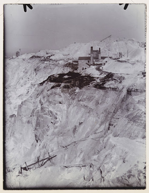
China Clay works, Lantern Pit and Cleaves Pit, North Cornwall, April 16th 1914
 |
| BGS Image ID: P804212 |
 |
| BGS Image ID: P804218 |
China clay is a material called kaolin and was used to make fine white porcelain. The extraction of China clay in the St. Austell area was one of the great extractive industries in Cornwall.
Bob McIntosh
Thursday, 14 November 2013
Happy birthday - Sir Charles Lyell born 14 November 1797
 |
| BGS Image ID: P517443 |
Charles Lyell, Bart. born 14 November 1797.
Sir Charles Lyell, a Scottish geologist was born 14 November 1797 near Kinnordy, near Kirriemuir. He was author of 'Principles of geology', published in 1830, it was a major work at the time that supported James Hutton's view on Uniformitarianism. He was also a keen supporter of geological surveys.
The British Geological Survey (BGS) and Heriot-Watt University are joining forces to create a new centre for earth and marine science and technology. Based in Edinburgh it will be called the Sir Charles Lyell Centre and will be one of Europe's leading centres for research and expertise in the earth and marine sciences. The centre is scheduled to open by 2015.
Jointly funded by UK and Scottish funders, Natural Environment Research Council (NERC), Scottish Funding Council (SFC) and Heriot-Watt University, The Sir Charles Lyell Centre will promote innovative research at the core of geoscience, marine ecology, computing, mathematics and engineering. The Lyell Centre will create a world-leading research cluster bringing science and technology together to tackle major issues of natural resource and energy supply in a responsible and sustainable way.
Full press release on the new centre.
Bob McIntosh
Tuesday, 12 November 2013
Landslip under Southdown between Beer Headland and Branscombe 1789-80
 |
| BGS image: P804446 |
Landslip under Southdown between Beer Headland and Branscombe which took place in 1789-90 looking Westward to Sidmouth Torbay and the Start Point. Artists impression filed with Excursion to Lyme Regis, June 1st 1914.
From the Geologists' Association 'Carreck Archive' on deposit at the British Geological Survey.
Does anyone have a recent picture of this spot?
Bob McIntosh
Friday, 8 November 2013
Origins of the British Geological Survey - a poster
The British Geological Survey has had a long history. Its origin was as part of the Ordnance Survey. It became a separate geological organization by 'Act of Parliament' in 1845 called the Geological Survey of Great Britain and Ireland. In 1965 it became a component institute of Natural Environment Research Council and the survey changed its name to Institute of Geological Sciences. There was a great expansion, it incorporated the Overseas Geological Survey which had it origins in the earlier Imperial Institute, also the units covering seismology and geomagnetism, the latter descended from the Royal Observatory at Greenwich. In 1984 the survey changed its name to the current British Geological Survey. In 2013 the the ownership and governance model is again under review.
The poster was created for a BGS Open Day.
Bob McIntosh
The poster was created for a BGS Open Day.
Bob McIntosh
Friday, 25 October 2013
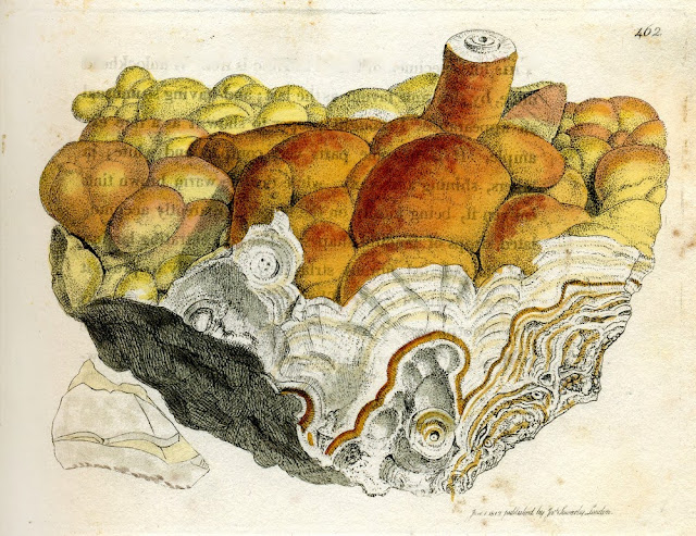
ZINCUM oxygenizatum, var. siliciferum. Silical Oxide of Zinc. From Sowerby, British Mineralogy
Sunday, 6 October 2013
Crushed samples of feldspar from Scotland
 |
| BGS image ID: P527656 |
Crushed samples of feldspar from Scotland
Potash feldspar was first in demand for the production of fertilizers, later during the Second World War deposits of potash feldspar were investigated for the production of ceramic ware. British Geological Survey Petrology Collection sample number MC 7436. To extract the potash numerous methods have been devised. They include 1. Simple wet grinding and electrolysis, this proved unsuccessful and only one-third of the alkali present could be extracted by this method. 2. Treatment with chemical solutions, either caustic alkalis or acids. 3. Volatization of potash-salts, this involved heating feldspar with gypsum and carbon with potassium sulphate being volatilized and then recovered. 4. A number of dry processes for the separation of potash existed e.g. separation of potash as hydroxide or carbonate; as sodium or potassium chlorides; extraction of sodium and potassium sulphate.
Bob McIntosh
Friday, 20 September 2013
British Association Section C. Dublin, 1908
Group photograph taken at the British Association for the Advancement of Science Meeting in Dublin, 1908. Gertrude Elles in centre, front row. Includes Tempest Anderson whose centenary it is this year.
Photograph from the Geologist Association Carreck Archive on deposit at the British Geological Survey.
Tuesday, 10 September 2013
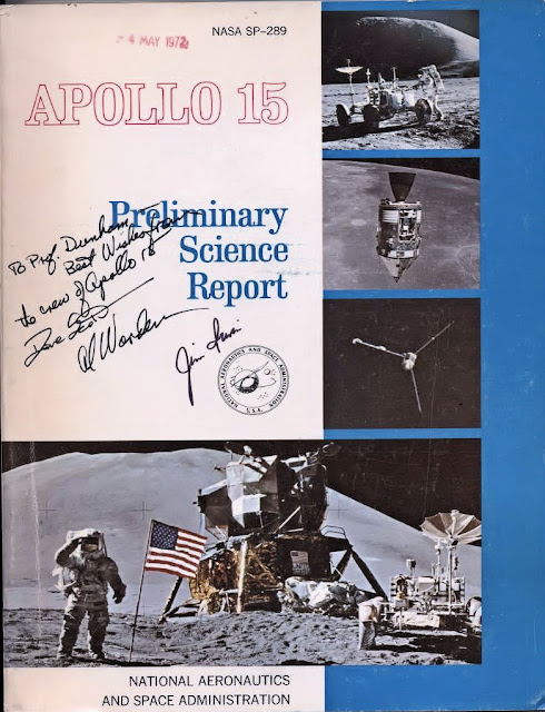
Inscribed copy of Apollo 15 Preliminary Science Report
 |
| BGS image ID: P858063 |
The Professor Dunham referred to is Kingsley Charles Dunham (1910-2001) who was the Professor of Geology at the University of Durham, 1950-1967 and Director of the Institute of Geological Sciences (now the British Geological Survey), 1967-1975.
Apollo 15 was launched on 26 July 1971, landed on the Moon on 30 July and splashed down back on Earth on 7 August. (Information from NASA mission pages). The report can be viewed here.
The British Geological Survey uses remote sensing techniques to study planetary geoscience. More can be read about that here.
Andrew L Morrison
Monday, 9 September 2013
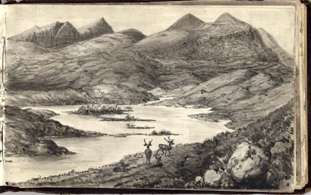
Ben Peach field notebook sketch
 |
| BGS image: P612917 |
Landscape sketch by Ben Peach, Victorian geologist.
Can anyone say where in Scotland this is?
Full two page picture:
Bob McIntosh
Labels:
Ben Peach,
field notebook,
lanscape,
Scotland,
sketch
Monday, 2 September 2013
Quarrying Caithness Flagstones, Stonegunn Quarry, c. 1910
 |
| BGS Image ID: P000022 |
Bob McIntosh
Thursday, 22 August 2013
Cardioceras densiplicatum Boden. A fossil ammonite.
 |
| BGS image ID: P521013 |
A fossil specimen of Cardioceras densiplicatum Boden. A fossil ammonite. (Mollusca, Cephalopoda, Ammonoidea.) 300 yards due south of Clyneleish House, Clyneleish, Brora, Sutherland, Scotland.
The genus Cardioceras belongs to the Subfamily Cardioceratinae. This specimen is from Brora, an important and well known Jurassic outcrop in East Sutherland. It is Callovian in age, which is the lowest division of the Upper Jurassic, a period marked by a marine transgression. British Geological Survey Biostratigraphy Collection number GSE 10338. Green Spot. Cardioceras is an ammonite with a moderately compressed shell, with a large outer whorl that becomes smooth. It has a strong keel and well differentiated ribs. The Cardioceratinae comprises four important genera, Quenstedtoceras, Goliathiceras, Cardioceras and Amoeboceras, they succeed each other stratigraphically with little overlap. Figd. W.J. Arkell, Mon. Pal. Soc. Vol. XCVI, 1943, pt VIII, pl LIII, fig 7; Figd. N.W. Hylland, Regional Handbook, pl XII, fig. 8.
The 'GB3D Type Fossils Online project' website has been launched today. Large numbers of fossil images are available including 3D images!
Bob McIntosh
Thursday, 15 August 2013
Trilobite. Acernaspis woodbarnensis Clarkson, Eldridge and Henry.
 |
| BGS image ID: P521140 |
The exoskeleton of Acernaspis can clearly be seen. It has a central axis and two side regions called pleurae. It is separated from anterior to posterior into a cephalon or head-shield, a thorax and a pygidium or tail-shield. The central region of the cephalon is called the glabella. Note the compound convex eye (like a fly's) made up of a number of separate lenses. This would give them a wide field of view forwards, backwards, sideways and upwards. The trilobites are the earliest of the arthropods. First found in rocks of Lower Cambrian age, they died out in the Permian. Throughout their 350 million year history they maintained a remarkable constancy of form, though with many varieties. All trilobites were marine. Figd. Clarkson, Elderidge, & Henry, pal. 20,plate 19, figs. 12,13.
BGS are involved in the 'GB3D Type Fossils Online project' where a large number of fossil images will be made available on the web including 3D images!
Bob McIntosh
Sunday, 11 August 2013
Sandstone from Ladycross Quarry, Slaley, Northumberland
 |
| BGS image ID: P524065 |
The sandstone is fine-grained with a speckled appearance due to the presence of abundant small dark grains of iron oxide. This specimen is of Carboniferous age. British Geological Survey Petrology Collection sample number MC6198. It contains parallel bedding laminae defined by thin dark surfaces of mica and iron oxide, and distinctive red-brown banding which represents iron oxidation fronts where iron oxides in the sandstone have undergone alteration and oxidation to form vivid colours. These fronts are generally parallel to bedding, but in some places they cut across it. Such thinly-bedded sandstones were historically used for paving, they could be easily split into regular thin sizes. Quarries such as Hailes in Edinburgh provided much paving in the past for that city. Nowadays with the old quarries now infilled, stones like this from Slaley are available for repair and restoration work. Size of specimen: 10x10x7 cm. Munsell colour code and colour N8 to 10YR7/2, variable from very light grey to pale orange.
BGS have over 4300 images from the National Building Stone Collection online in the Geoscenic image resource. They can be browsed either by rock type/place or place/rock type.
Thursday, 8 August 2013
Geological Survey Department of Northern Rhodesia, c.1960
This photograph of the staff of the Geological Survey Department of Northern Rhodesia was taken outside their headquarters in Lusaka in around 1960. Sitting in the middle of the front row is William Henry Reeve from whose collection this picture comes. Reeve (1906-?) was Mineral exploration geologist in Northern and Southern Rhodesia for the Anglo-American Corporation of South Africa (1930-1933), Assistant field geologist, Tanganyika (1935-1939), Assistant field geologist, Nyasaland (1943), Engineer-Geologist, Kenya (1943-1951), Chief Geologist, Northern Rhodesia (1951-1952) and Director of the Geological Survey Department, Northern Rhodesia (1952-1961).
 |
| BGS image ID: P856634 |
This photograph of the staff of the Geological Survey Department of Northern Rhodesia was taken outside their headquarters in Lusaka in around 1960. Sitting in the middle of the front row is William Henry Reeve from whose collection this picture comes. Reeve (1906-?) was Mineral exploration geologist in Northern and Southern Rhodesia for the Anglo-American Corporation of South Africa (1930-1933), Assistant field geologist, Tanganyika (1935-1939), Assistant field geologist, Nyasaland (1943), Engineer-Geologist, Kenya (1943-1951), Chief Geologist, Northern Rhodesia (1951-1952) and Director of the Geological Survey Department, Northern Rhodesia (1952-1961).
A newspaper article which covered the opening of the HQ in 1956 reported that "Mr W H Reeve, Director of the Geological Survey, said the department now had, for the first time, many facilities of educational value, including an ore museum, a scientific and technical reference library, new laboratories and a drawing office."
Andrew L Morrison
Wednesday, 7 August 2013
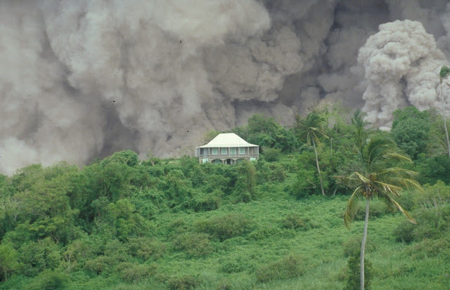
Tar River Estate House, Soufriere Hills Volcano, Montserrat.
 |
| BGS image ID: P063643 |
BGS hold an extensive photographic archive of the volcanic activity on Montserrat. 23,000 images are available on Geoscenic, the BGS online image service.
Bob McIntosh
Subscribe to:
Comments (Atom)


![Caption: Workmen with rods for searching for Palaeolithic implements, Milton Street Gravel Pits, Kent. T.W. Reader 23.5.08. [1908] Caption: Workmen with rods for searching for Palaeolithic implements, Milton Street Gravel Pits, Kent. T.W. Reader 23.5.08. [1908]](https://blogger.googleusercontent.com/img/b/R29vZ2xl/AVvXsEhWEvFrIY6GotRnsLY4beaYqwKT1KqdoSMgMJBfqz_KDHtJLuRle-R9y_9cd86hnljvVWWQpGgklyjIoTdgB1HdBNlk513g__jZE3kBS1cZ11QPFPEuyCVEGM1Zf4yha1sBVO4xpsXXfeU/s640/A_PJW5491.jpg)
![Caption: Some members examine the Flint Implement collection of Mr. Treacher. [Llewellyn Treacher] T.R.W. 25.6.10 [1910] Caption: Some members examine the Flint Implement collection of Mr. Treacher. [Llewellyn Treacher] T.R.W. 25.6.10 [1910]](https://blogger.googleusercontent.com/img/b/R29vZ2xl/AVvXsEgk13mXoXt5c2H15zepY99Rsx3Sy7Vi6s0PMAYeCwtxg7I3jIJNp9vdgdIVUY-P8XPzEYHmvSYa5KerndImlc48G-pgOLEPb-NX2GZXW4hoPJ6S1qqFFI1p9qe-QYZepjr_soOktFpaWxY/s640/B_PJW5491.jpg)

