Sunday, 30 June 2013

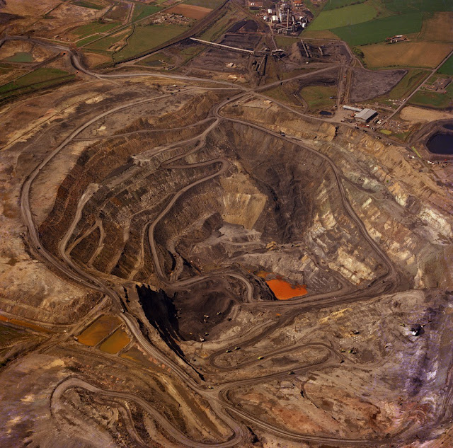
Oblique aerial view of Blindwells Opencast Site, Tranent, 1996.

Oblique aerial view of Blindwells Opencast Site, Tranent, looking from the east-north-east. Working opencast coal site, in coals of the Limestone Coal Formation, showing various stages in the process. The working face is in the foreground; backfilled spoil in the centre - colours of each load derive from different materials, white and pale brown = sandstone, pale and dark grey = siltstone and shale, dark brown = glacial till overburden; black area = coal storage, pale brown areas = restored overburden. Top left is worked area fully restored to agricultural use. Bottom right is undisturbed ground.
BGS image ID: P001315
Oblique aerial view of Blindwells Opencast Site, Tranent, East Lothian, looking from the east-north-east. Working opencast coal site, in coals of the Limestone Coal Formation, showing various stages in the process. The working face is in the foreground; backfilled spoil in the centre - colours of each load derive from different materials, white and pale brown = sandstone, pale and dark grey = siltstone and shale, dark brown = glacial till overburden; black area = coal storage, pale brown areas = restored overburden. Top left is worked area fully restored to agricultural use. Bottom right is undisturbed ground.


Bob McIntosh

Saturday, 29 June 2013

Joseph Beete Jukes M.A., F.R.S.

 Joseph Beete Jukes 1811-1869. Born at Summerhill, near Birmingham. Studied under Sedgwick. Worked in Newfoundland and on H.M. Ship 'Fly' surveying the coast of Australia and New Guinea. Joined the Geological Survey of Great Britain and Ireland in 1846 and by 1850 was appointed to the post of Director of Geological Survey Ireland.
BGS image ID:  P505852

Joseph Beete Jukes 1811-1869. Born at Summerhill, near Birmingham. Studied under Sedgwick. Worked in Newfoundland and on H.M. Ship 'Fly' surveying the coast of Australia and New Guinea. Joined the Geological Survey of Great Britain and Ireland in 1846 and by 1850 was appointed to the post of Director of Geological Survey Ireland.

More details can be found in Joseph Beete Jukes page in the new biographical resource: Pioneers of the British Geological Survey. Browse the 'Pioneers'


 Joseph Beete Jukes 1811-1869. Born at Summerhill, near Birmingham. Studied under Sedgwick. Worked in Newfoundland and on H.M. Ship 'Fly' surveying the coast of Australia and New Guinea. Joined the Geological Survey of Great Britain and Ireland in 1846 and by 1850 was appointed to the post of Director of Geological Survey Ireland.
BGS image ID:  P575755
Bob McIntosh

Friday, 28 June 2013

Scottish oil shale distillates, 1905 vintage.

Samples of the different distillates and products that are produced during the processing of Scottish oil-shale. Samples on the left contain distillates that are intermediary stages in the process such as the crude oil, crude distillate (green oil), blue oil. Samples on the right are the final products that are marketed for a range of uses e.g. motor spirit, lighthouse oil, cleaning spirit.
BGS image ID: P528115
Samples of the different distillates and products that are produced during the processing of Scottish oil-shale. Samples on the left contain distillates that are intermediary stages in the process such as the crude oil, crude distillate (green oil), blue oil. Samples on the right are the final products that are marketed for a range of uses e.g. motor spirit, lighthouse oil, cleaning spirit.

Top row, left to right: Crude Shale Oil, Crude Distillate, Blue Oil, Heavy Oil and Paraffin, Crude Naptha, Crude Burning Oil. 
Bottom row, left to right: Crude Scrubber Naptha, Sulphate of Ammonia, Ammoniacal Liquor, Motor Spirit, Lighthouse Oil, Power Oil, Cleaning Spirit.


Diagram illustrating processes of manufacture in the Scottish oil-shale industry. The diagram shows the complete process from the original shale through the various treatments and distillations and showing the end products. The process can be conveniently considered in two stages. The raw oil-shale is distilled/heated in retorts in the absence of air and in the presence of steam. This allows the shale to undergo decomposition and distillation into crude oil and ammonia. The second stage is refining the crude oil. The object is to obtain from the crude oil various types of refined oil and wax as required by the prevailing markets at the lowest possible working cost and with the smallest amount of capital spent on refining plant.
BGS image ID: P528117
Diagram illustrating processes of manufacture in the Scottish oil-shale industry.

The diagram shows the complete process from the original shale through the various treatments and distillations and showing the end products. The process can be conveniently considered in two stages. The raw oil-shale is distilled/heated in retorts in the absence of air and in the presence of steam. This allows the shale to undergo decomposition and distillation into crude oil and ammonia. The second stage is refining the crude oil. The object is to obtain from the crude oil various types of refined oil and wax as required by the prevailing markets at the lowest possible working cost and with the smallest amount of capital spent on refining plant.

Other samples from the Scottish Shale oil industry

Bob McIntosh

Thursday, 27 June 2013

Westfield Opencast Coal Mine, 1977.

Oblique aerial view of the Westfield Opencast Coal Mine from the north-east Fife Region. Cut to extract the abnormally thick development of coals (Boglochty Beds) in the Passage Group of the Namurian of the Scottish Carboniferous succession. The excavation is about 200 metres deep and has cut through strata from just above the top of the Middle Coal Measures (Westphalian B) down to the Calmy Limestone of Namurian (E2) age. At the top are the processing plants. The Westfield Open Pit was worked by Costain Mining Limited on behalf of the National Coal Board Opencast Executive.
BGS image ID: P001513
Oblique aerial view of the Westfield Opencast Coal Mine from the north-east Fife Region. Cut to extract the abnormally thick development of coals (Boglochty Beds) in the Passage Group of the Namurian of the Scottish Carboniferous succession. The excavation is about 200 metres deep and has cut through strata from just above the top of the Middle Coal Measures (Westphalian B) down to the Calmy Limestone of Namurian (E2) age. At the top are the processing plants. The Westfield Open Pit was worked by Costain Mining Limited on behalf of the National Coal Board Opencast Executive.

Excavation commenced in 1955 on the site of the former Kirkness Colliery, production started the following year, 1956. It was regarded at the time as the largest opencast in the UK and possibly Europe.


Old photograph number: D02514

Photograph taken 1977.

Bob McIntosh


Wednesday, 26 June 2013

Ball clay manufactures, Heathfield Potteries, Newton Abbot.

Heathfield Potteries, Newton Abbot. Bovey Tracey ball clays. Great Western Potteries, Heathfield. Pipe making. Clay is fed on the floor above, into the pipe press (on left) and moulded under pressure. The picture shows a pipe partly removed from the press. On removal it is put vertically on a wooden slab and placed on a revolving table (in front of central figure) where, while turning, it is trimmed and has grooves made at both ends with a comb. The pipe is then stocked for drying before firing.
BGS image ID: P208108
Heathfield Potteries, Newton Abbot. Bovey Tracey ball clays. Great Western Potteries, Heathfield. Pipe making. Clay is fed on the floor above, into the pipe press (on left) and moulded under pressure. The picture shows a pipe partly removed from the press. On removal it is put vertically on a wooden slab and placed on a revolving table (in front of central figure) where, while turning, it is trimmed and has grooves made at both ends with a comb. The pipe is then stocked for drying before firing.

BGS old photograph number: A08186.  Date of photograph 1945.
Heathfield Potteries, Newton Abbot. Bovey Tracey ball clays. Great Western Potteries, Heathrfield. Various irregularly shaped articles such as drain traps, ? section pipes and special bends which cannot be made mechanically are moulded by hand. The photograph shows a mould partly made on the bench. On the floor are several drain trap moulds, two completed drain traps and a curved ? section pipe.
BGS image ID: P208109
Heathfield Potteries, Newton Abbot. Bovey Tracey ball clays. Great Western Potteries, Heathrfield. Various irregularly shaped articles such as drain traps, ? section pipes and special bends which cannot be made mechanically are moulded by hand. The photograph shows a mould partly made on the bench. On the floor are several drain trap moulds, two completed drain traps and a curved ? section pipe.

BGS old photograph number: A08187. Date of photograph 1945.

Bob McIntosh

Tuesday, 25 June 2013

Cartoon by H T De la Beche

Cartoon by H T De la Beche
BGS image ID: P832328
This cartoon was drawn by Henry De la Beche and features himself. The writing at the bottom says "Opportunity of studying the effects of rain on glass. Devon 1831". This would have been during the time that De la Beche was carrying out a geological examination of South Devonshire for a hobby. His income came from a sugar plantation in Jamaica but money was running short and he would have found delays caused by the weather very frustrating.

Andrew L Morrison

Making grindstones, Messrs. Armitage's Quarry, Normanton

Messrs. Armitage's Quarry, Normanton. Looking NE. Middle Coal Measures. Grindstone constructed from Woolley Edge Rock.
BGS image ID: P206950
Messrs. Armitage's Quarry, Normanton, Yorkshire. Looking NE. Middle Coal Measures. Grindstone constructed from Woolley Edge Rock, a massive Coal Measure sandstone.

BGS old photograph number A07025. Date taken: 1936

Bob McIntosh

Monday, 24 June 2013

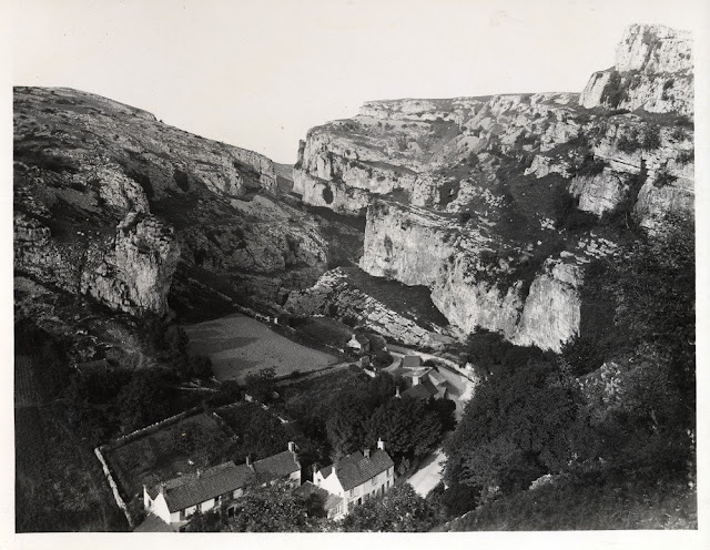
Cheddar Gorge in 1894.

Cheddar Gorge. Lying on the southern edge of the Mendip Hills the gorge in Carboniferous Limestone was formed by mettwater floods in periglacial periods
BGS image ID: P233315
Lying on the southern edge of the Mendip Hills the gorge in Carboniferous Limestone was formed by meltwater floods in periglacial periods.
Cheddar Gorge. Lying on the southern edge of the Mendip Hills the gorge in Carboniferous Limestone was formed by mettwater floods in periglacial periods
BGS image ID: P233316
Photographer: F.J. Allen.  Taken in 1894. Photographs are from the British Association for the Advancement of Science collections held in the British Geological Survey.

Sunday, 23 June 2013

Here lived William Smith, Tucking Mill, Somerset in 1890.

Here lived William Smith " Father of English Geology" Born 23rd March 1769, Died 28th August 1839. Plaque on wall at Tucking Mill, Somerset.
BGS image ID: P259913
Here lived William Smith " Father of English Geology" Born 23rd March 1769, Died 28th August 1839. Plaque on wall at Tucking Mill, Somerset.
Tucking Mill, 1890
BGS image ID: P259997
Tucking Mill, 1890. The mill which was demolished in 1927.

Images are from the British Association for the Advancement of Science Photograph Collection held on deposit at the British Geological Survey.

Bob McIntosh

Saturday, 22 June 2013

Stonehenge

Stonehenge, Amesbury. Looking E. 35 degrees N. Stonehenge. Outer Circle from within and Inner Circle of foreign stones represented by the stump and two erect masses of dolerite. To the left is one of the intact trilithons, and one of the dolerites of the Inner Horseshoe.
BGS image ID: P203213
Stonehenge, Amesbury. Looking E. 35 degrees N. Stonehenge. Outer Circle from within and Inner Circle of foreign stones represented by the stump and two erect masses of dolerite. To the left is one of the intact trilithons, and one of the dolerites of the Inner Horseshoe.
Stonehenge, Amesbury. Looking N. 15 degrees E. Stonehenge. Stones (fallen and erect) of the Outer Circle from without showing the two remaining trilithons.
BGS image ID: P203217
Looking N. 15 degrees E. Stonehenge. Stones (fallen and erect) of the Outer Circle from without showing the two remaining trilithons.

Photographs taken 1926 by J. Rhodes.

Bob McIntosh

Friday, 21 June 2013

The Giant's Causeway

Giant's Causeway. Looking SE. Columnar jointing in tholeiitic basalt. The columns are usually from five to seven sided with ball and socket cross-joints.  Old photograph number:  NI00708
BGS image ID: P006483
Giant's Causeway. Looking SE. Columnar jointing in tholeiitic basalt. The columns are usually from five to seven sided with ball and socket cross-joints. 
Old photograph number: NI00708

Giant's Causeway. Looking SE. Columnar tholeiitic basalt, showing ball and socket cross-jointing. The cross-joints are upward and downward facing in apparently random pattern. Old photograph number:  NI00706
BGS image ID: P225384
Giant's Causeway. Looking SE. Columnar tholeiitic basalt, showing ball and socket cross-jointing. The cross-joints are upward and downward facing in apparently random pattern.
Old photograph number:  NI00706
Giant's Causeway. Looking N. The Middle Causeway. Columnar tholeiitic lava. Old photograph number:  NI00710
BGS image ID: P225386
Giant's Causeway. Looking N. The Middle Causeway. Columnar tholeiitic lava.
Old photograph number:  NI00710

Bob McIntosh

Thursday, 20 June 2013

E.O. Teale, geologist 1874-1971

BGS image ID: P776406
Australian Edmund Oswald Teale (formerly Theile) (1874-1971) worked in East Africa from 1908 to 1936 mostly on geological surveys.  Teale's archive held at the British Geological Survey includes a typescript autobiography, extensive diaries, testimonials and photographs. 

Bob McIntosh

Wednesday, 19 June 2013

Lavernock, Images from the BAAS Collection

Penarth-Lavernock. Sections of Penarth Beds, etc., from Penarth Head to Lavernock. 1892. Photograph by C.J. Watson. From the British Association for the Advancement of Science photograph collection.
BGS image ID: P232603
Sections of Penarth Beds, etc., from Penarth Head to Lavernock. 1892. Photograph by C.J. Watson. From the British Association for the Advancement of Science photograph collection.
Lavernock Point. Lower Lias and Rhaetic shale. 1901. Photograph by S.H. Reynolds. From the British Association for the Advancement of Science photograph collection.
BGS image ID: P239939
Lavernock Point. Lower Lias and Rhaetic shale. 1901. Photograph by S.H. Reynolds. From the British Association for the Advancement of Science photograph collection.

Bob McIntosh

Tuesday, 18 June 2013

The Norber erratics, Clapham, Yorkshire

Glacial erratics. Norber, near Clapham. Boulders of Silurian rock perched on Carboniferous Limestone. From the British Association for the Advancement of Science photograph collection. 1896.
BGS image ID: P234618
Glacial erratics. Norber, near Clapham. Boulders of Silurian rock perched on Carboniferous Limestone. From the British Association for the Advancement of Science photograph collection. 1896.
BGS image ID: P234619

Glacial erratics. Norber, near Clapham. Boulders of Silurian rock perched on Carboniferous Limestone. From the British Association for the Advancement of Science photograph collection. 1896.

Photographer: Geoffrey Bingley.

Bob McIntosh

Monday, 17 June 2013

Picture relating to the career of Tom Eastwood

Picture relating to the career of Tom Eastwood
BGS image ID: P832327
Tom Eastwood (1888-1970) joined the Geological Survey in 1911 and retired in 1949. The sketches of the other geologists are (top, left to right) Frederick Murray Trotter, Sydney Ewart Hollingworth (bottom, left to right) William Colin Campbell Rose, Francis Brian Awburn Welch, Kingsley Charles Dunham.

Andrew L Morrison

Edith Cadmore and Margaret S. Walker. From Geologists' Association 'Carreck Archive'

Edith Cadmore and Margaret S. Walker. From Geologists' Association 'Carreck Archive'.

Edith Cadmore and Margaret S. Walker. From Geologists' Association 'Carreck Archive'.
Edith Cadmore was on the Council of the Geologists' Association and was also Secretary for various GA field trips. 

Does anyone have information about Margaret S. Walker?

Bob McIntosh

Sunday, 16 June 2013

Hutton's Section, Salisbury Craigs, Holyrood Park, Edinburgh

Hutton's Section, Salisbury Craigs, Holyrood Park. Classic locality associated with James Hutton; shows intrusive features at base of Salisbury Craigs sill; teschenite chilled by sediment; sediments broken, twisted and baked by intrusion. P005962
BGS image ID: P005962
Hutton's Section, Salisbury Craigs, Holyrood Park, Edinburgh, Midlothian.

Classic locality associated with James Hutton; shows intrusive features at base of Salisbury Craigs sill; teschenite chilled by sediment; sediments broken, twisted and baked by intrusion. 


Hutton's Section, Salisbury Craigs, Holyrood Park. Classic locality associated with James Hutton; shows intrusive features at base of Salisbury Craigs sill; teschenite chilled by sediment; sediments broken, twisted and baked by intrusion. P005962
BGS image ID: P002877
Hutton's Section, Salisbury Craigs, Holyrood Park, Edinburgh, Midlothian. 

This is the classic locality, associated with James Hutton, which shows the base of the Salisbury Craigs Sill intruded into Lower Carboniferous sandstones, shales and cementstones of the Ballagan Formation, Inverclyde Group. The sill is chilled (with very fine-grained crystals) against the underlying sandstones which are locally baked and hardened by the heat given out as the sill cooled. The sediments are also broken, twisted and wedged apart by the forceful intrusion of the magma.

Bob McIntosh

Saturday, 15 June 2013

Fingal's Cave, Staffa

Fingal's Cave, Staffa. Columnar basalt. From the British Association for the Advancement of Science photograph collection
BGS image ID: P246033
Fingal's Cave, Staffa. Columnar basalt. From the British Association for the Advancement of Science photograph collection. Date: 1906.


Oblique aerial view of The Great Face, the south end of the island of Staffa. Argyll and Bute. The Boat Cave is on the left and Fingal's Cave on the right. Massive, straight, well-formed columnar jointing in the Tertiary volcanic lava flow. The classic type of columnar jointing consists of a close-packed series of hexagonal 'prisms' lying perpendicular, in this case, to the base of the lava flow. Columnar jointing is formed by contraction during the cooling of the lava when a pattern of tensional forces acting towards a number of centres is set up. These forces tend to pull open a series of joints which ideally assume a hexagonal pattern.
BGS image ID: P000773
Oblique aerial view of The Great Face, the south end of the island of Staffa. Argyll and Bute. The Boat Cave is on the left and Fingal's Cave on the right. Massive, straight, well-formed columnar jointing in the Tertiary volcanic lava flow. The classic type of columnar jointing consists of a close-packed series of hexagonal 'prisms' lying perpendicular, in this case, to the base of the lava flow. Columnar jointing is formed by contraction during the cooling of the lava when a pattern of tensional forces acting towards a number of centres is set up. These forces tend to pull open a series of joints which ideally assume a hexagonal pattern. Date of image: 1977.

Bob McIntosh

Friday, 14 June 2013

Geologist's uniform, Geological Survey of Great Britain

A BGS geologist models the uniform of Sir Andrew Crombie Ramsay. This uniform is of the type "Levy dress" worn when attending Court. Sir A.C. Ramsay was appointed to the Survey in  1841 and suceeded Sir Henry De La Beche to become the third Director of the Geological Survey 1871-1881.

A BGS geologist models the uniform of Sir Andrew Crombie Ramsay. This uniform is of the type 'Levée dress' worn when attending Court. Sir A.C. Ramsay was appointed to the Survey in 1841 and succeeded Sir Henry De La Beche and Roderick Impey Murchison to become the third Director of the Geological Survey 1871-1881.

The uniform was kindly loaned by Dr. Margaret Wood of GeoMôn Angelsey GeoPark who was given the uniform by Sir Kyffin Williams R.A. a relative of Sir Andrew and said 'they were used by Ramsay for ceremonial occasions and in other words his official uniform.'


A selection of buttons from the Survey's field uniform, unfortunately no pictures of the full field uniform exists.

As befitting an organization with origins in the early Ordnance Survey (under the Board of Ordnance) and when it was a military organization, the geologists had to wear a uniform of a blue frock coat with very military style buttons. The uniform proved unpopular and unsuitable for the rigours of field life and was soon dropped.

'During the first 10 years of its existence the Geological Survey was a branch of the Board of Ordnance. Its officers wore a dark blue official uniform. But a tight-fitting, well-buttoned frock coat could only be an inconvenient garment for the rough scrambling and climbing life of a field-geologist. It was accordingly discarded when the Survey in 1845 was placed under the Office of Woods and Forests. Each officer thenceforth chose the civilian garb that pleased him.' A. Geikie. A long life's work.

Bob McIntosh

Thursday, 13 June 2013

Storm damage in Aberystwyth, October 28th 1927 and January 15th 1938


N. end of Marine Terrace, Aberystwyth. Effects of storm of Oct. 28th, 1927.
BGS image ID: P252861
N. end of Marine Terrace, Aberystwyth. Effects of storm of Oct. 28th, 1927.


Borth, N. of Aberystwyth. Effects of storm of Oct. 28th, 1927.
BGS image ID: P252866
Borth, N. of Aberystwyth. Effects of storm of Oct. 28th, 1927.


 Victoria Terrace, Aberystwyth. Effect of gale of Jan. 15, 1938.
BGS image ID: P257998
 Victoria Terrace, Aberystwyth. Effect of gale of Jan. 15, 1938.

All three images are from the British Association for the Advancement of Science photograph collection.


Bob McIntosh

Wednesday, 12 June 2013

'Big Geordie' dragline, Butterwell Opencast Coal Site, Northumberland.

'Big Geordie' dragline. Butterwell Opencast Coal Site, Northumberland. The dragline ('Big Geordie') used to excavate rock from the deepest parts of the excavation. The gently sloping benches from which successively higher coal seams are extracted can be clearly seen in the background.
BGS image ID: P064546
Butterwell Opencast Coal Site, Northumberland. The Bucyrus-Erie 1550-W walking dragline ('Big Geordie') used to excavate rock from the deepest parts of the excavation. The gently sloping benches from which successively higher coal seams are extracted can be clearly seen in the background.

Big Geordie's bucket. Butterwell Opencast Coal Site, Northumberland.
BGS image ID: P260809
Big Geordie's bucket. Butterwell Opencast Coal Site, Northumberland.

Bob McIntosh

Tuesday, 11 June 2013

Development of potholes in Monessie Gorge, Grampian Region

The upstream end of Monessie Gorge. Grampian Region. Development of potholes in the Leven Schists Formation, Appin Group, Dalradian Supergroup. The gorge is cut into garnetiferous quartz-mica-schists of the Leven Schist Formation with a dominant spaced cleavage. The impressive potholes are due to abrasion rounded, massive quartzite and granodiorite boulders swept downstream from Inverlair and from the Strath Ossian Igneous Complex respectively.
BGS image ID: P001150
The upstream end of Monessie Gorge. Grampian Region. Development of potholes in the Leven Schists Formation, Appin Group, Dalradian Supergroup. The gorge is cut into garnetiferous quartz-mica-schists of the Leven Schist Formation with a dominant spaced cleavage. The impressive potholes are due to abrasion rounded, massive quartzite and granodiorite boulders swept downstream from Inverlair and from the Strath Ossian Igneous Complex respectively.
Date taken: 01/07/1989

Bob McIntosh

Monday, 10 June 2013

Bog iron ore from Scotland

Bog iron ore from Lon Odhar, South Erradale, Gairloch, Ross and Cromarty.  The South Erradale bog iron ore is a good example of ore from the comparatively small pans that occur in the Loch Maree area were associated with the long history of bloomeries and furnaces in the area. British Geological Survey Petrology Collection sample number MC 7359. An early analysis by Ivison Macadam of two samples of South Erradale bog iron ore are sample a, 70.88 per cent ferric oxide; 49.61 per cent metallic iron; 7.48 per cent silica. Sample b, 66.68 per cent ferric oxide; 46.67 per cent metallic iron and 8.24 per cent silica. It is thought that the deposits were so small and few that the local bog iron ores would have been exhausted in early times and that iron would have been imported from elsewhere, possibly haematite from Cumberland and clayband ironstone from Fifeshire.
BGS image ID: P527579
Bog iron ore from Lon Odhar, South Erradale, Gairloch, Ross and Cromarty.

The South Erradale bog iron ore is a good example of ore from the comparatively small pans that occur in the Loch Maree area associated with the long history of bloomeries and furnaces in the area. British Geological Survey Petrology Collection sample number MC 7359. An early analysis by Ivison Macadam of two samples of South Erradale bog iron ore are sample a, 70.88 per cent ferric oxide; 49.61 per cent metallic iron; 7.48 per cent silica. Sample b, 66.68 per cent ferric oxide; 46.67 per cent metallic iron and 8.24 per cent silica. It is thought that the deposits were so small and few that the local bog iron ores would have been exhausted in early times and that iron would have been imported from elsewhere, possibly haematite from Cumberland and clayband ironstone from Fifeshire.


Bog iron ore from an iron pan on the west shore of Kirst Shun, one quarter of a mile north-north-east of Clothister Hill, Shetland.  Bog iron ore from an iron pan on the west shore of Kirst Shun, one quarter of a mile north-north-east of Clothister Hill, Shetland. It is recorded that in 1874 Shetland produced 692 tons of bog iron ore. British Geological Survey Petrology Collection sample number MC 7361. Evidence for the earliest traces of iron-making in Scotland can be seen in the bloomeries where local bog iron ore of recent origin was smelted. They arose in several areas due to the availability of bog iron ore and a good supply of timber for charcoal making. Bog iron ore is a general term for soft, spongy and porous sedimentary deposits of impure hydrous iron oxides formed in bogs, swamps, marshes, peat mosses and shallow lakes from the chemical precipitation from iron-bearing waters and by the oxidizing action of algae, iron bacteria or the atmosphere.
BGS image ID: P527581
Bog iron ore from an iron pan on the west shore of Kirst Shun, one quarter of a mile north-north-east of Clothister Hill, Shetland. 

It is recorded that in 1874 Shetland produced 692 tons of bog iron ore. British Geological Survey Petrology Collection sample number MC 7361. Evidence for the earliest traces of iron-making in Scotland can be seen in the bloomeries where local bog iron ore of recent origin was smelted. They arose in several areas due to the availability of bog iron ore and a good supply of timber for charcoal making. Bog iron ore is a general term for soft, spongy and porous sedimentary deposits of impure hydrous iron oxides formed in bogs, swamps, marshes, peat mosses and shallow lakes from the chemical precipitation from iron-bearing waters and by the oxidizing action of algae, iron bacteria or the atmosphere.

Saturday, 8 June 2013

Stormy seas in the Drake Passage, Scotia Sea, southern Atlantic Ocean, RRS James Clark Ross

Drake Passage, Scotia Sea, southern Atlantic Ocean. Stormy sea crashing onto the after deck of the RRS James Clark Ross, engulfing the sub sea vibrocorer.  The Drake Passage is crossed by the RRS James Clark Ross several time each season en-route from The Falkland Islands to the Antarctic. Located near the Antarctic Peninsula, the Drake Passage is famous for its stormy seas and spectacular icebergs. This photograph shows the James Clark Ross after deck being awash having been engulfed by a large wave whilst steaming north to Stanley after a successful sampling cruise off the Antarctic Peninsula.
BGS image ID: P507038
Drake Passage, Scotia Sea, southern Atlantic Ocean. Stormy sea crashing onto the after deck of the RRS James Clark Ross, engulfing the sub sea vibrocorer.

The Drake Passage is crossed by the RRS James Clark Ross several time each season en-route from The Falkland Islands to the Antarctic. Located near the Antarctic Peninsula, the Drake Passage is famous for its stormy seas and spectacular icebergs. This photograph shows the James Clark Ross after deck being awash having been engulfed by a large wave whilst steaming north to Stanley after a successful sampling cruise off the Antarctic Peninsula.


RRS James Clark Ross in quieter water.
BGS image ID: P506915
RRS James Clark Ross in quieter water.

Date of photographs: 2000. Photographer: G. Tulloch.

Bob McIntosh

Friday, 7 June 2013

Letter from Jenny Blake to F W Rudler

Letter from Jenny Blake to F W Rudler
BGS image ID: P828709
This sad letter from 13 year old Jenny Blake was written in 1886. It was enclosed inside another letter from her father Charles Carter Blake (c1840-c1887) who was an anthropologist, palaeontologist and comparative anatomist. Both letters were sent to Frederick William Rudler (1840-1915) who worked for the Geological Survey and Museum from 1861-1876 and 1879-1902. It is not known what befell Charles Blake and his family.

Andrew L Morrison

Scottish alluvial gold from Kildonan Burn, Helmsdale


Alluvial gold from Kildonan Burn, Helmsdale, Sutherland.

Alluvial gold occurs in alluvial gravels and is found in a great variety of forms. It can appear black and rusty or appear to be light in weight when the gold particles are small. Gold is a heavy, soft, malleable, ductile yellow metallic element. It is unusual in that it occurs naturally as the native metal. The Suisgill and Kildonan streams are regarded as the most auriferous in the district. The source of the gold has not been found. In 1868 and 1869 there was a minor gold rush in the diggings near Kildonan.

Bob McIntosh

Thursday, 6 June 2013

Notice relating to female visitors at the Geological Survey and Museum

Notice relating to female visitors at the Geological Survey and Museum
BGS image ID: 827763
This notice was issued in 1921 by John S Flett who was the then Director of the Geological Survey and Museum. It is not known if there was a particular incident which resulted in it being written.

The name "Mr Cantrill" has been written in pencil in the top left-hand corner. This is probably Thomas Crosbee Cantrill (1867-1931) who joined the Survey in 1896 and retired in 1927 by which time he was a District Geologist.

Andrew L Morrison

Edinburgh Castle Rock and the Arthur's Seat volcano

Oblique aerial view of Edinburgh Castle Rock and the Arthur's Seat volcano, looking from the west-north-west. In the foreground, Edinburgh Castle sits on dolerite plugging a Lower Carboniferous volcanic vent intruded into softer sedimentary rocks. Glaciation from the west has left the crag-and-tail feature formed by the hard crag of the Castle Rock and the tail of the Royal Mile stretching eastwards. The remnants of another Lower Carboniferous volcano form Queen's Park in the middle distance: the Arthur's Seat summit is formed of agglomerate and intrusions filling the volcanic vents; the ridges of Whinny Hill to the left (north) are the remains of the lava flows. The sharp Salisbury Craigs in front are formed of a slightly younger teschenite (dolerite) sill.
BGS image ID: P001266
Oblique aerial view of Edinburgh Castle Rock and the Arthur's Seat volcano, looking from the west-north-west. In the foreground, Edinburgh Castle sits on dolerite plugging a Lower Carboniferous volcanic vent intruded into softer sedimentary rocks. Glaciation from the west has left the crag-and-tail feature formed by the hard crag of the Castle Rock and the tail of the Royal Mile stretching eastwards. The remnants of another Lower Carboniferous volcano form Queen's Park in the middle distance: the Arthur's Seat summit is formed of agglomerate and intrusions filling the volcanic vents; the ridges of Whinny Hill to the left (north) are the remains of the lava flows. The sharp Salisbury Craigs in front are formed of a slightly younger teschenite (dolerite) sill.

Bob McIntosh

Wednesday, 5 June 2013

Charles Lapworth, graptolites and Birkhill Cottage

BGS image ID: P015041
 Charles Lapworth  1842-1920 - portrait.

An English geologist known for first describing the Ordovician period. This was carefully worked out by his new technique of faunal analysis of 'index fossils' especially graptolites. He was also a key participant in the 'Highland Controversy' when he was first to say that there were older rocks lying over younger and suggesting the cause being complex folding or faulting.

Birkhill Cottage where between 1872 & 1877 Charles Lapworth recognized the value of Graptolites as a clue to the geological structure of these hills. Erected by Scottish Geologists, 1931.
BGS iamge ID: P217123
Plaque on Birkhill Cottage commemorating Charles Lapworth. The inscription reads:

Birkhill Cottage where between 1872 & 1877 Charles Lapworth recognized the value of Graptolites as a clue to the geological structure of these hills. Erected by Scottish Geologists, 1931.


A fossil specimen of Torquigraptus linterni sp. nov. A fossil graptolite. (Graptolithina). Pot Burn, Ettrick Valley, Southern Uplands, Selkirkshire, Scotland.  Torquigraptus linterni sp. nov. is an Ordovician graptolite from the Birkhill Shales, Moffat Shale Group. British Geological Survey Biostratigraphy Collection number GSE 15158. The specimen has a coiled uniserial rhabdosome. The type area of the Birkhill Shales is the famous Dobb's Linn near Birkhill Cottage at the head of Moffat Water. The Birkhill Shales is a series of black graptolitic mudstones found in bands between 0.1 and 0.3 metres thick overlain by alternations of black and grey mudstones. It is famous for its graptolite fauna. Graptolites are of value in geology as stratigraphic indicators and the sequence of graptolite faunas has been used for the subdivision of the Ordovician and the Silurian rocks since the time of Charles Lapworth
BGS image ID: P5211147
A fossil specimen of Torquigraptus linterni sp. nov. A fossil graptolite. (Graptolithina). Pot Burn, Ettrick Valley, Southern Uplands, Selkirkshire, Scotland.

Torquigraptus linterni sp. nov. is an Ordovician graptolite from the Birkhill Shales, Moffat Shale Group. British Geological Survey Biostratigraphy Collection number GSE 15158. The specimen has a coiled uniserial rhabdosome. The type area of the Birkhill Shales is the famous Dobb's Linn near Birkhill Cottage at the head of Moffat Water. The Birkhill Shales is a series of black graptolitic mudstones found in bands between 0.1 and 0.3 metres thick overlain by alternations of black and grey mudstones. It is famous for its graptolite fauna. Graptolites are of value in geology as stratigraphic indicators and the sequence of graptolite faunas has been used for the subdivision of the Ordovician and the Silurian rocks since the time of Charles Lapworth.

A fossil specimen of Diplograptus truncatus Lapworth var. pauperatus Elles and Wood. A fossil graptolite. (Graptolithina.) Dobb's Linn, Moffat Water, near Birkhill about 9.5 miles north-east of Moffat, Dumfriesshire, Scotland.  Diplograptus lived between the Middle Ordovician to the Lower Silurian (Llanvirn to Landovery). This specimen is from the Lower Hartfell Shales. British Geological Survey Biostratigraphy Collection number GSE 8231. It is biserial, it has two rows of thecae arranged back to back and grew in an upwards direction away from the sicula and scandent (stipes grow upwards from the sicula with the thecae growing outwards). Graptolites are related to the living Protochordata. They consisted of colonies of tiny individuals enclosed in a common horny sheath. They were widely distributed as they floated in the surface waters of the ancient oceans. On death the sheaths sank to the ocean floor and were buried and preserved.
BGS image ID: P521143
A fossil specimen of Diplograptus truncatus Lapworth var. pauperatus Elles and Wood. A fossil graptolite. (Graptolithina.) Dobb's Linn, Moffat Water, near Birkhill about 9.5 miles north-east of Moffat, Dumfriesshire, Scotland.

Diplograptus lived between the Middle Ordovician to the Lower Silurian (Llanvirn to Landovery). This specimen is from the Lower Hartfell Shales. British Geological Survey Biostratigraphy Collection number GSE 8231. It is biserial, it has two rows of thecae arranged back to back and grew in an upwards direction away from the sicula and scandent (stipes grow upwards from the sicula with the thecae growing outwards). Graptolites are related to the living Protochordata. They consisted of colonies of tiny individuals enclosed in a common horny sheath. They were widely distributed as they floated in the surface waters of the ancient oceans. On death the sheaths sank to the ocean floor and were buried and preserved.

Bob McIntosh