Friday 5 December 2014

On the manufacture of gun-flints, Memoir of the Geological Survey 1879.

Title page of: Memoir Geological Survey. England and Wales. On the manufacture of gun-flints, the method of excavating for flint, the age of Palaeolithic Man and the connexion between Neolithic art and the gun-flint trade by Sydney B.J. Skertchly. London : HMSO, 1879.

Title page of: Memoir Geological Survey. England and Wales. On the manufacture of gun-flints, the method of excavating for flint, the age of Palaeolithic Man and the connexion between Neolithic art and the gun-flint trade by Sydney B.J. Skertchly. London : HMSO, 1879. The memoir is an exhaustive account of the making of gun-flints at Brandon in Sussex.

The memoir is a regarded as a classic by modern day flint knappers.


Sample page showing a few of the wide range of gun-flints that were available at the time - all with interesting names such as Mixed Grey or Spotted Horse Pistol, Chalk-heeled Horse Pistol, Best Carbine, Solid Grey Musket etc.

Sample page showing descriptions of the thirty-three gun-flints that were available at the time. The gun-flints had interesting names such as Mixed Grey or Spotted Horse Pistol, Chalk-heeled Horse Pistol, Best Carbine, Solid Grey Musket etc. They were all made by eye, no measurements were involved.

Illustration showing knappers at work.

Illustration showing knappers at work. Flint was mined from chalk pits, each pit lasting from six to nine months. The miners sold the flints to the flint knappers by the 'jag' which is one cart-load about equal to a ton. 

To manufacture the gun-flints there were four processes:

Drying - flint would be dried outside in the summer but in the winter it was dryed around the fire indoors.

Quartering - a block of stone is taken and quartered - they may weigh a quarter of a hundredweight to two hundredweights.

Flaking - The most difficult process and requires great skill and 'nicety of judgement'.

Knapping - The final process of forming the flakes into gun-flints. A good flake will make four, and a very good one five flints. An average workman will knap 3,000 flints in a day of 12 hours. One man working from 4 a.m. until 11 p.m. made 24,000 in a week!

Illustration showing how a flint fractures to provide a series of flakes. Just one stage in the process of making gun-flints.

Illustration showing how a flint fractures to provide a series of flakes. Just one stage in the process of making gun-flints.

Watch a video on flint mining and knapping at Brandon in the 1930s and 1940s here  and here. Definitely worth watching!

Posted by Bob McIntosh

Friday 14 November 2014

Flints from Piltdown, Sussex

These flints were found in a gravel pit at Piltdown in Sussex by Charles Dawson (1864-1916), a local solicitor and amateur archaeologist. The gravel pit was the same one in which the now infamous Piltdown Man was discovered. It is widely believed that Dawson was responsible for this audacious fraud.

Large flint from gravel bed, Piltdown, Sussex
BGS image ID: P903735

Glazed flints from Piltdown gravel, Sussex
BGS image ID: P903736

Large flint from Piltdown gravel, Sussex
BGS Image ID: P903738

BGS has a Piltdown Forgery webpage and timeline which can be accessed here

Andrew L Morrison

Monday 3 November 2014

Penmaenmawr Mountain Top Quarry

Penmaenmawr Mountain Top Quarry. Conveyors down to loading pier.
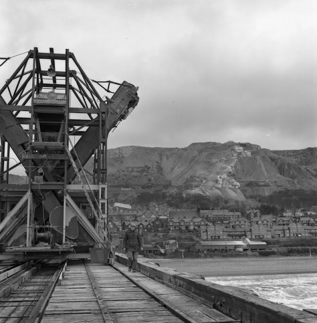
BGS Image ID: P539567

Penmaenmawr Mountain Top Quarry. Conveyors down to loading pier.

Penmaenmawr Mountain Top Quarry. Ship loading jetty - some of output went by boat to London.
BGS Image ID: P539617

Ship loading jetty - some of output went by boat to London.

Penmaenmawr Mountain Top Quarry. Drilling shot holes
BGS Image ID: P539574

Drilling shot holes.

Images from the Hugh O'Neill collection. Photographs taken c 1960-61.

Posted by: Bob McIntosh

Monday 20 October 2014

English churches - building stones


Drewsteignton village square, Devon. Looking east. Drewsteignton village is sited high on the northern edge of Dartmoor. Holy Trinity Church and Church House with its large chimney stack are both built of Dartmoor granite blocks. Drewsteignton village is typical of many on the the northern fringe of Dartmoor. The church tower is built of Dartmoor granite (imported to the district). The house to the right of the lych gate is built largely of rough hewn granite blocks. The wall to the left of the lych gate is built of blocks of impure limestone and hornfelsed mudstone from the local quarries (now disused). The granites of Devon and Cornwall and their associated intrusive and metamorphic rocks have commonly been worked in the past for building stone, both for local housing and for major building projects elswhere in the United Kingdom such as the many 19th century dock construction schemes in London.
BGS Image ID: P209976
Drewsteignton village square, Devon. Looking east. Drewsteignton village is sited high on the northern edge of Dartmoor. Holy Trinity Church and Church House with its large chimney stack are both built of Dartmoor granite blocks. Drewsteignton village is typical of many on the the northern fringe of Dartmoor. The church tower is built of Dartmoor granite (imported to the district). The house to the right of the lych gate is built largely of rough hewn granite blocks. The wall to the left of the lych gate is built of blocks of impure limestone and hornfelsed mudstone from the local quarries (now disused). The granites of Devon and Cornwall and their associated intrusive and metamorphic rocks have commonly been worked in the past for building stone, both for local housing and for major building projects elswhere in the United Kingdom such as the many 19th century dock construction schemes in London.

Snettisham Church, Norfolk. Looking east. This large, late medieval church at Snettisham is typical of many in this area where a mixture of local building stones are used for the main walling material, chalk, flints and ferruginous carstone, with better quality oolitic freestones of the Lincolnshire Limestone Formation imported for more ornate mouldings and carved stonework. Built in the 14th century decorated style, Snettisham Church has its nave and tower constructed of partially dressed blocks of chalk and flint. The spire, pinnacles, copings, buttresses and window tracery are made of oolitic limestone, one of the Middle Jurassic freestones. The wall in the foreground is made of dressed Carstone blocks which have suffered some frost damage. While this area of Norfolk produced a wide variety of local building materials, including sandstones, limestones and flints, none were good enough to qualify as freestones. Consequently from medieval times onwards the oolitic limestones of Lincolnshire were commonly imported for the stonework in all the more prestigious buildings.
BGS Image ID: P210728
Snettisham Church, Norfolk. Looking east. This large, late medieval church at Snettisham is typical of many in this area where a mixture of local building stones are used for the main walling material, chalk, flints and ferruginous carstone, with better quality oolitic freestones of the Lincolnshire Limestone Formation imported for more ornate mouldings and carved stonework. Built in the 14th century decorated style, Snettisham Church has its nave and tower constructed of partially dressed blocks of chalk and flint. The spire, pinnacles, copings, buttresses and window tracery are made of oolitic limestone, one of the Middle Jurassic freestones. The wall in the foreground is made of dressed Carstone blocks which have suffered some frost damage. While this area of Norfolk produced a wide variety of local building materials, including sandstones, limestones and flints, none were good enough to qualify as freestones. Consequently from medieval times onwards the oolitic limestones of Lincolnshire were commonly imported for the stonework in all the more prestigious buildings.


St Mary's Church, Purton, Wiltshire. Looking north-west. This Norman / Medieval church with its spire and crossing tower is constructed of Jurassic Coral Rag limestones. The term Rag refers to the coarse grained shelly (or ragged nature) of the limestone when fractured. The ragstone beds are generally very hard and durable stones but are consequently, therefore, very difficult to work, commonly they are used as undressed rubblestone blocks. This church at Purton is largely built of local 'Coral Rag' Limestone from the local Osmington Oolite Formation.The roof of the church is covered with stone slates which in this area are likely to be from the Forest Marble Formation, although some use of local Purbeck limestones is also known. The hard, pale grey, coarsely oolitic and shelly limestones of the Corallian Group were widely used in buildings along their outcrops in Dorset, Wiltshire and Oxfordshire.
BGS Image ID: P210855
St Mary's Church, Purton, Wiltshire. Looking north-west. This Norman / Medieval church with its spire and crossing tower is constructed of Jurassic Coral Rag limestones. The term Rag refers to the coarse grained shelly (or ragged nature) of the limestone when fractured. The ragstone beds are generally very hard and durable stones but are consequently, therefore, very difficult to work, commonly they are used as undressed rubblestone blocks. This church at Purton is largely built of local 'Coral Rag' Limestone from the local Osmington Oolite Formation.The roof of the church is covered with stone slates which in this area are likely to be from the Forest Marble Formation, although some use of local Purbeck limestones is also known. The hard, pale grey, coarsely oolitic and shelly limestones of the Corallian Group were widely used in buildings along their outcrops in Dorset, Wiltshire and Oxfordshire.

Posted by Bob McIntosh

Tuesday 7 October 2014

BGS maps portal — maps and sections 1832 to 2014

Sheet 10 [Isle of Wight, Lyrnington, part of Portsmouth Harbour.] Geological Survey of England and Wales Old Series. 1:63,360. 1856.
Sheet 10 [Isle of Wight, Lyrnington, part of Portsmouth Harbour.] Geological Survey of England and Wales Old Series. 1:63,360. 1856.
Two sheets separated by 157 years. Both available as high resolution scans on the new BGS Maps Portal  

Isle of Wight special sheet. Geological Survey of England and Wales 1:50,000 map. 2013

The British Geological Survey (BGS) has  released high resolution scans of over 6000 geological maps which were previously published on paper. The “BGS Maps Portal” provides free to view small and medium scale maps produced by the BGS since geological mapping began in 1832. The Maps Portal includes the recent 1:50,000 mapping of England, Wales and Scotland, geochemical and geophysical maps and also the historical maps that were in the former BGS historical maps website. 

Posted by Bob McIntosh

Thursday 18 September 2014

Franklin's Ships: Records from HMS Erebus and HMS Terror

‘Term day books’ from HMS Erebus and HMS Terror, 1840-1842, containing both magnetic and meteorological observations

‘Term day books’ from HMS Erebus and HMS Terror, 1840-1842, containing both magnetic and meteorological observations.


Sir John Franklin’s fabled lost expedition, back in the news last week after one of the ships was found by Canadian search vessels, was not the first time that the two ships HMS Erebus and HMS Terror set sail together on a voyage of exploration. Six years before Erebus and Terror departed England for the Arctic, they were beginning a four year expedition that would take them southwards to the Antarctic. On that journey they were led by Captain James Clark Ross, an experienced polar explorer, with the second in command (and commander of HMS Terror) being Francis Crozier. Crozier was captain of the same ship on Franklin’s expedition, and is reported to have taken charge after Franklin’s death, with some suggestions that he survived for several years afterwards. 

One of the aims of both Ross’s Antarctic expedition and Franklin’s Arctic one was to collect magnetic data, and the data relating to the Antarctic can still be found in BGS’s collections today. Both HMS Erebus and HMS Terror recorded information relating to the earth’s magnetic field, as well as making meteorological observations such as details of aurora sightings. BGS holds similar records of many other Royal Navy ships, with data collected around the world throughout the nineteenth and early twentieth centuries. A list of Royal Navy ships’ geomagnetic log books held by BGS can be found here. Records of Ross’s expedition also live on in the names of many Antarctic landmarks – for example the Ross Ice Shelf, Ross Sea, and Ross Island with its two volcanoes Mount Erebus and Mount Terror.

See below for more images of records from HMS Erebus and HMS Terror.


Term day book and other papers containing magnetic and meteorological observations from HMS Erebus, 1840-1843. James Ross’s signature can be seen in the centre.

Term day book and other papers containing magnetic and meteorological observations from HMS Erebus, 1840-1843. James Ross’s signature can be seen in the centre.


Magnetic observations taken at Auckland Island (to the south of New Zealand), 5th December 1840, and Van Diemen’s Land (now Tasmania), May 1841, from HMS Erebus

Magnetic observations taken at Auckland Island (to the south of New Zealand), 5th December 1840, and Van Diemen’s Land (now Tasmania), May 1841, from HMS Erebus.

Papers from HMS Terror, 1841-1842. The document on the right compares magnetic observations from HMS Terror with those made at Ross Bank, Tasmania.

Papers from HMS Terror, 1841-1842. The document on the right compares magnetic observations from HMS Terror with those made at Ross Bank, Tasmania. 


Francis Crozier’s signature on a document recording auroras seen from HMS Terror in March 1842

Francis Crozier’s signature on a document recording auroras seen from HMS Terror in March 1842.

Monday 8 September 2014

Forth Road Bridge construction. 50th Anniversary

A main lift. Images from the Hugh O'Neill collection of the construction of the Forth Road Bridge.
BGS image ID: P537923
A main lift. Images from the Hugh O'Neill collection of the construction of the Forth Road Bridge.

South Pier. Images from the Hugh O'Neill collection of the construction of the Forth Road Bridge.
BGS image ID: P537924
South pier.

Tensioning cables. Forth Road Bridge construction.
BGS image ID:  P537894
Tensioning cables.

Institute of Quarrying visit.  Forth Road Bridge construction.
BGS image ID: P537898
Institute of Quarrying visit

Tension cables. Forth Road Bridge construction.
BGS image ID: P537895
Tension cables.


Posted by Bob McIntosh

Monday 25 August 2014

Haematite vein from Eas an Fholaich, near Loch Eilt, west of Fort William

Part of a haematite vein from Eas an Fholaich, near Loch Eilt, west of Fort William, Invernessshire. Haematite is an iron ore mineral composed of iron oxide. It belongs to the hexagonal crystal system and can occur as stubby black rhombohedral crystals or more commonly massive, granular masses, compact, or soft and earthy. It has a dark cherry streak. British Geological Survey Petrology Collection sample number MC 7446. There is evidence that haematite in veins has been known in Scotland from a very early date. In the middle of the 18th century haematite was mined at Tomintoul, Pennel Burn in Ayrshire and at Garleton in East Lothian. Iron ores come in many forms from bog iron ores, sedimentary bedded ores, to ore deposits injected as metalliferous intrusions. Haematite is often in the latter category.
BGS Imager ID: P527666

Part of a haematite vein from Eas an Fholaich, near Loch Eilt, west of Fort William, Invernessshire. British Geological Survey Petrology Collection sample number MC 7446. 

Haematite is an iron ore mineral composed of iron oxide. It belongs to the hexagonal crystal system and can occur as stubby black rhombohedral crystals or more commonly massive, granular masses, compact, or soft and earthy. It has a dark cherry streak. There is evidence that haematite in veins has been known in Scotland from a very early date. In the middle of the 18th century haematite was mined at Tomintoul, Pennel Burn in Ayrshire and at Garleton in East Lothian. Iron ores come in many forms from bog iron ores, sedimentary bedded ores, to ore deposits injected as metalliferous intrusions. Haematite is often in the latter category.

Posted by Bob McIntosh

Wednesday 13 August 2014

Mining subsidence in Ferniehill, Edinburgh, 2000

BGS Image ID: P100363
Ferniehill, Gilmerton, Edinburgh. Limestone mine subsidence event, November 9th 2000 to March 2001; 'Tumbledown Terrace'. The subsidence has caused damage to buildings, roads etc. The Carboniferous Gilmerton Limestone was quarried and mined at Ferniehill from time immemorial until about 1829. Collapsing old limestone mineworkings were responsible for what became catastrophic damage to many properties.

Download a leaflet explaining the subsidence, by Mike Bowne


BGS image ID:  P100365

BGS image ID: P100398
Posted by Bob McIntosh

Saturday 2 August 2014

William Smith, Geological section from London to Snowdon, 1819

William Smith: Geological section from London to Snowdon showing the varieties of the strata and the correct altitudes of the hills. Published: London : J. Carey, 1819.

William Smith: Geological section from London to Snowdon showing the varieties of the strata and the correct altitudes of the hills. Published: London : J. Carey, 1819.


Extract from William Smith's Geological section from London to Snowdon showing the Stonebrash Hills, the Chalk hills and the intervening Vale of Isis and Vale of Aylesbury.

Extract from William Smith's Geological section from London to Snowdon showing the Stonebrash Hills, the Chalk Hills and the intervening Vale of Isis and Vale of Aylesbury.


Extract from William Smith's Geological section from London to Snowdon showing the Stonebrash Hills, the Chalk hills and the intervening Vale of Isis and Vale of Aylesbury.

Extract from William Smith's Geological section from London to Snowdon showing the mountains of North Wales.

The section came with an accompanying 'Legend'.


Posted by Bob McIntosh

Tuesday 22 July 2014

Letter from Admiralty to Geological Museum, 1917

BGS Archive Ref: GSM/DR/St/A/20
 
This letter relates to materials suitable for making compasses for aeroplanes. Such compasses would have to be reliable,  able to survive the rigours of flight and not wear out. The letter is an example of the more unusual subjects that the Geological Survey was consulted about during the First World War.

Posters relating to the Survey's contribution to the war effort 1914-1918 can be viewed here

Andrew L Morrison


Sunday 20 July 2014

Malmesbury Abbey, Wiltshire, Middle Jurassic limestone

Malmesbury Abbey, Malmesbury, Wiltshire. Looking north-east.   Malmesbury Abbey was constructed in the 12th century of pale yellow, oolitic limestone from the Middle Jurassic limestones of the Bath area (Box Ground Stone). Only part of the Abbey now remains intact. The pale yellow oolitic limestones used in the Abbey have proved to be reasonably durable probably because the building is in a rural setting away from the problems caused by the industrial pollution of the last few centuries. A monastery was established on the site in around 676 but this building dated from the 12th century when the building was consecrated in 1180. The south portch is the most natable feature that survives from that period. At one time the abbey had a spire taller than salisbury Cathedral but it fell down some time before the Reformation when Henry VIII dissolved the monastery in 1539. Dissolution of the monastries in the 16th century lead to the stripping, sale and removal of building materials from many monastic buildings such as Malmesbury Abbey.
BGS Image ID:P212039

Malmesbury Abbey, Malmesbury, Wiltshire. Looking north-east. 

Malmesbury Abbey was constructed in the 12th century of pale yellow, oolitic limestone from the Middle Jurassic limestones of the Bath area (Box Ground Stone). Only part of the Abbey now remains intact. The pale yellow oolitic limestones used in the Abbey have proved to be reasonably durable probably because the building is in a rural setting away from the problems caused by the industrial pollution of the last few centuries. A monastery was established on the site in around 676 but this building dated from the 12th century when the building was consecrated in 1180. The south portch is the most natable feature that survives from that period. At one time the abbey had a spire taller than salisbury Cathedral but it fell down some time before the Reformation when Henry VIII dissolved the monastery in 1539. Dissolution of the monastries in the 16th century lead to the stripping, sale and removal of building materials from many monastic buildings such as Malmesbury Abbey.
Date taken: 1977


Malmesbury Abbey, Wiltshire. One of the characteristic features of Norman ecclesiastical architecture is the high quality of the building materials selected and the outstanding workmanship of their masons. The remains of Malmsbury Abbey, now the parish church still preserve examples of this fine craftsmanship in stone. Considered to be one of the most outstanding examples of Norman decorative stone carving in Britain, this doorway in the south porch of the Abbey is carved from oolitic limestone from the Middle Jurassic, Box Ground Quarries near Bath. The limestones generically known as Bath Stones are one of the principal sources of building limestone in the United Kingdom. They were worked from numerous mines in the vicinity of the Bath which now sits upon several kilometres of old stone mine galleries. The limestones are pale to dark yellow in colour and dominantly oolitic though some shelly ragstone beds were also worked.
BGS Image ID: P212040

One of the characteristic features of Norman ecclesiastical architecture is the high quality of the building materials selected and the outstanding workmanship of their masons. The remains of Malmsbury Abbey, now the parish church still preserve examples of this fine craftsmanship in stone. Considered to be one of the most outstanding examples of Norman decorative stone carving in Britain, this doorway in the south porch of the Abbey is carved from oolitic limestone from the Middle Jurassic, Box Ground Quarries near Bath. The limestones generically known as Bath Stones are one of the principal sources of building limestone in the United Kingdom. They were worked from numerous mines in the vicinity of the Bath which now sits upon several kilometres of old stone mine galleries. The limestones are pale to dark yellow in colour and dominantly oolitic though some shelly ragstone beds were also worked.

Posted by Bob McIntosh

Monday 30 June 2014

PLUMBUM Galaena. Sulphure of Lead; Galena. Plate no. 24. From: Sowerby, James. 1802-1817. British Mineralogy

PLUMBUM Galaena. Sulphure of Lead; Galena. Plate no. 24. From: Sowerby, James. 1802-1817. British Mineralogy: Or Coloured figures intended to elucidate the mineralogy of Great Britain. Plate from vol: 1. page no.55. Modern name: Galena. Location: Collected found in Derbyshire.
BGS Image ID: P704650

PLUMBUM Galaena. Sulphure of Lead; Galena. Plate no. 24. From: Sowerby, James. 1802-1817. British Mineralogy: Or Coloured figures intended to elucidate the mineralogy of Great Britain. Plate from vol: 1. page no. 55. Modern name: Galena. Location: Collected found in Derbyshire.

Posted by Bob McIntosh

Sunday 22 June 2014

Settle Lime, November 1960. The new Priest kilns.

Settle Lime, Nov 1960, north of Settle, Ingleborough, Horton and Threshfield. The new kilns
BGS Image ID: P538126
Settle Lime, Nov 1960, north of Settle, Ingleborough, Horton and Threshfield. The new kilns. Priest kilns.

From the Hugh O'Neill collection.

Posted by Bob McIntosh

Sunday 15 June 2014

Crossing water, E.O. Teale Collection

Crossing a river by bridge,  Mbeya, Tanganyika Territory, 1928. E.O. Teale Collection
BGS Image ID: P776556
Crossing a river by bridge,  Mbeya, Tanganyika Territory, 1928.

Crossing a river by raft. E.O. Teale Collection
BGS Image ID: P776485
Crossing a river by raft

Crossing a river by precarious footbridge. E.O. Teale Collection
BGS Image ID: P776490
Crossing a river by precarious footbridge

Wading a river. E.O. Teale Collection
BGS Image ID: P776527
Wading across a river

Photographs are from the E.O. Teale Collection. 

Also see :


River transport by traditional 'dugout' canoe. Gold Coast. 1919

Posted by Bob McIntosh


Sunday 8 June 2014

Land Rover photographs in the BGS archives

A set of photographs for Land Rover fans!
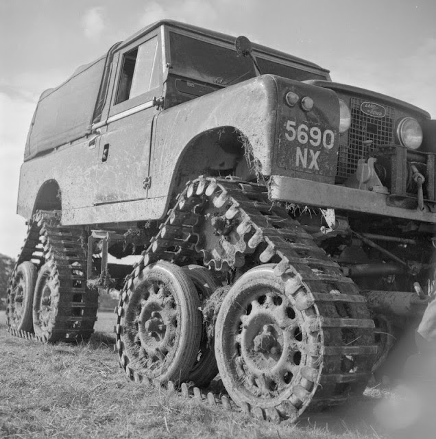
Track conversion close-up. 4 independent tracks, the front two being steered through the normal steering system. The cost of the kit is £650.
BGS Image ID: P539250
Track conversion close-up. 4 independent tracks, the front two being steered through the normal steering system. The cost of the kit was £650.

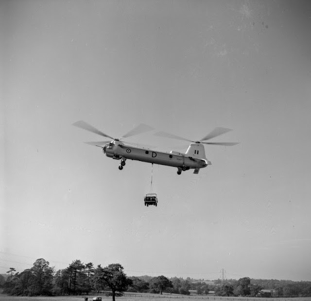
Land Rover demonstation, Solihull. Bristol Type 192 Belvedere helicopter carrying a Land Rover.
BGS ImageID:  P539249
Land Rover demonstation, Solihull. Bristol Type 192 Belvedere helicopter carrying a Land Rover.

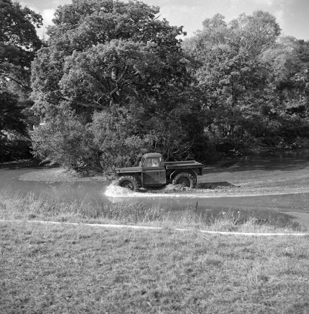
Land Rover demonstation, Solihull. Large wheel conversion.
BGS Image ID: P539252
Land Rover demonstation, Solihull. Large wheel conversion.

Land Rover demonstation, Solihull. Rail conversion. Road wheels have been replaced by Duthene-treated tyres, this gives very good traction. One vehicle pulled 52 tons of wagons.
BGS Image ID: P539253
Land Rover demonstation, Solihull. Rail conversion. Road wheels have been replaced by Duthene-treated tyres, this gives very good traction. One vehicle pulled 52 tons of wagons.

Plant demonstration Soil Fertility Limited. Crop spraying Land Rover with hovercraft assist.
BGS Image ID: P539860
Plant demonstration Soil Fertility Limited. Crop spraying Land Rover with hovercraft assist.


Plant demonstration Soil Fertility Limited. Crop spraying Land Rover with hovercraft assist.
BGS Image ID: P539861
Plant demonstration Soil Fertility Limited. Crop spraying Land Rover with hovercraft assist.

Photographs from the Mr. Hugh O'Neill Collection. Most of the photographs in this collection are of quarries in the UK. Dates are c. 1961.

Posted by Bob McIntosh

Sunday 1 June 2014

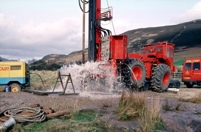
Groundwater drilling in Scotland

Hardthorn Road site, Dumfries, Dumfries and Galloway Region. Water strike during drilling for groundwater at Hardthorn Road.   The rotary drilling rig encountered only dry Permian breccia to 56 m. depth. At this level, a water-bearing fissure suddenly produced a surge of water at the surface. Other fissures were encountered at intervals to 130 m. depth. The final yield of water from the borehole was over 35 litres per second. The borehole is to be used by West of Scotland Water as part of the Dumfries public supply system. The Silurian hills can be seen in the background. These encircle the Permian aquifer in the floor of the basin.
BGS Image ID: P001426
Hardthorn Road site, Dumfries, Dumfries and Galloway Region. Water strike during drilling for groundwater at Hardthorn Road. 

The rotary drilling rig encountered only dry Permian breccia to 56 m. depth. At this level, a water-bearing fissure suddenly produced a surge of water at the surface. Other fissures were encountered at intervals to 130 m. depth. The final yield of water from the borehole was over 35 litres per second. The borehole is to be used by West of Scotland Water as part of the Dumfries public supply system. The Silurian hills can be seen in the background. These encircle the Permian aquifer in the floor of the basin.

Adjacent to the A70 road near Tarbrax, Strathclyde Region. A V-notch tank in use during a pumping test on an exploratory groundwater borehole.   The borehole was drilled by West of Scotland Water as an exercise to see whether groundwater could be used to supply the village of Tarbrax, and replace an unreliable surface stream source. The borehole, drilled into Upper Devonian sandstone and mudstone, yielded over 7 litres/second. The V-notch tank is used to measure the water flow, by comparing the height of water flowing over the V with flow rates in a reference table. The drill rig in the background was used to drill the borehole and install the electric pump to 50 m. depth.
BGS Image ID: P001434
 Adjacent to the A70 road near Tarbrax, Strathclyde Region. A V-notch tank in use during a pumping test on an exploratory groundwater borehole. 

The borehole was drilled by West of Scotland Water as an exercise to see whether groundwater could be used to supply the village of Tarbrax, and replace an unreliable surface stream source. The borehole, drilled into Upper Devonian sandstone and mudstone, yielded over 7 litres/second. The V-notch tank is used to measure the water flow, by comparing the height of water flowing over the V with flow rates in a reference table. The drill rig in the background was used to drill the borehole and install the electric pump to 50 m. depth.

Bridge Farm borehole, Machrie, Arran. An artesian, flowing, borehole drilled into the Permian sandstone aquifer at Machrie, Arran. A T.V. log of the borehole is being undertaken, using a BGS Land Rover.  The flow of water was measured at 10 litres/second, which makes it one of the highest naturally-flowing boreholes in Scotland. Most of the water is coming into the borehole at depths between 65 m. and 95 m. below ground level. The quality of the water is very high, and it is hoped that West of Scotland Water will use this source for most of the island's water supply before 2002.
BGS Image ID: P001440
Bridge Farm borehole, Machrie, Arran. An artesian, flowing, borehole drilled into the Permian sandstone aquifer at Machrie, Arran. A T.V. log of the borehole is being undertaken, using a BGS Land Rover.

The flow of water was measured at 10 litres/second, which makes it one of the highest naturally-flowing boreholes in Scotland. Most of the water is coming into the borehole at depths between 65 m. and 95 m. below ground level. The quality of the water is very high, and it is hoped that West of Scotland Water will use this source for most of the island's water supply before 2002.

Bridge Farm borehole, Machrie, Arran. Drilling a groundwater production borehole for West of Scotland Water at Machrie, Arran.  The drill rig is located close to the 'String' road from Brodick at a site chosen by the Hydrogeology Group of BGS. The rig is using an air flush hammer to drill through Permian sandstone. The compressor is seen at the left. Compressed air is sent down the drill rods to the hammer at the bottom of the borehole. The air operates the hammer and brings cuttings and water to the surface. The water flows away from the site to a stream. The 4-wheel drive tractor unit powers the rig and is highly manoeuvrable - useful for sites with problematical access.
BGS Image ID: P001441
Bridge Farm borehole, Machrie, Arran. Drilling a groundwater production borehole for West of Scotland Water at Machrie, Arran.

The drill rig is located close to the 'String' road from Brodick at a site chosen by the Hydrogeology Group of BGS. The rig is using an air flush hammer to drill through Permian sandstone. The compressor is seen at the left. Compressed air is sent down the drill rods to the hammer at the bottom of the borehole. The air operates the hammer and brings cuttings and water to the surface. The water flows away from the site to a stream. The 4-wheel drive tractor unit powers the rig and is highly maneuverable - useful for sites with problematical access.

Photographs by Derek Ball

Posted: Bob McIntosh