Friday 31 May 2013

Samples from horizontal sections published by the Geological Survey of Great Britain and Ireland.

Samples of horizontal sections from those published by the Geological Survey of Great Britain and Ireland. The sections were all hand-coloured with water colour paints and were issued at a horizontal scale of 1:10,560.

Samples of horizontal sections from those published by the Geological Survey of Great Britain and Ireland. The sections were all hand-coloured with water colour paints and were issued at a horizontal scale of 1:10,560.

Samples of horizontal sections from those published by the Geological Survey of Great Britain and Ireland. The sections were all hand-coloured with water colour paints and were issued at a horizontal scale of 1:10,560.

Samples of horizontal sections from those published by the Geological Survey of Great Britain and Ireland. The sections were all hand-coloured with water colour paints and were issued at a horizontal scale of 1:10,560.

Samples from horizontal sections published by the Geological Survey of Great Britain and Ireland. The sections were all hand-coloured with water colour paints and were issued at a horizontal scale of 1:10,560.


Extract from the 1897 'Summary of Progress of the Geological Survey of Great Britain and Ireland' [Download full document] :

Horizontal sections
The Horizontal Sections have been an important feature in the work of the Geological Survey. De La Beche, recognising the practical disadvantages arising from the construction of sections without any regard to the proportion between height and distance, instituted the practice of drawing them on a true scale. He adopted the scale of six inches, to a mile, and invented a system of patterns for the different kinds of rock, which, as he was himself an artist, are appropriate and effective, for they represent in no small measure the general structure of the rocks. The institution of such sections, in lieu of the distorted diagrams too generally employed, was of great service to the Survey itself and also to the progress of geology; for it served to correct the evil influences of distorted drawing, with regard not only to geological structure but to the true forms of the ground.


When a line of section was chosen and traced on the one-inch map, it had to be measured on the ground with chain and theodolite. This was the invariable practice until the six-inch contoured Ordnance Survey maps came into use. Where these maps can be used as a basis, the laborious process of chaining the sections is no longer required. The section lines are drawn on these maps and the sections are plotted from them. The contour-lines and benchmarks allow the line of the surface to be traced with a close approximation to accuracy. But in order to ensure final correctness of detail, the ground is gone over with the section (and where needful, an Abney's level) in hand, and each little feature is then put in.

The sections start from Ordnance datum (mean sea-level), but where the ground is low and there is consequently not room to express what is known of the geological structure above that datum, the lines are prolonged below it. The same practice is also followed in mining-districts. An effort has been made to illustrate every great district of the country by means of horizontal sections. Each geological formation, as it varies from one point to another, is crossed by lines of section, so that by comparing these with each other the changes in that formation from district to district can at once be seen. The length of each section varies indefinitely with the nature of the ground, many of them being upwards of 100 miles in length. Thus a series of sections runs from Anglesey and the coast of Merionethshire, across the mountainous ground of North Wales, to the plains of the Midlands. Another group crosses from the central counties to the South Coast. A connected chain of sections traverses the breadth of the island from Liverpool to the coast of Yorkshire.

As an illustration of the character of these sections and their usefulness in correcting popular misconceptions as to geological structure and the form of the ground, reference may be made to that which runs from Leicestershire to Brighton and passes through London (Sheet 79). What is called the 'London basin' is by many people regarded as a deep trough of Clay, with the Chalk rising steeply from under it both to the, south and north, and we may see this conception embodied in actual diagrams in text-books and elsewhere. But in reality both the London Clay and the Chalk are so nearly flat that their inclination can hardly be detected except by careful measurement. And the section, accurately plotted from borings and well sections, shows them apparently horizontal, though on further inspection we find that their line of junction, which is well above the datum-line at either end, lies several hundred feet beneath it in the centre.

The Horizontal Sections are engraved on copper and published in sheets, each of which, if the ground be low, may include six lines or 36 miles of section. The same continuous line of section may thus extend over several sheets. Small explanatory pamphlets are usually published with these sheets, giving general information as to their rocks and their local peculiarities. Each sheet of Horizontal Sections is published at the price of 5s. In all, 193 sheets of such sections for the United Kingdom have been issued.

Besides the usual Horizontal Sections on the scale of six inches to a mile, occasional sections on a larger scale are prepared to illustrate the geological structure of particular localities. In this way the coast-line of Cromer and Yarmouth has been represented in detail, and its numerous features of geological interest have been inserted so as to exhibit a kind of picture of the arrangement of the strata in these changing cliffs. Portions of the coast-line of Dorset and of the Isle of Wight have been similarly treated.

Bob McIntosh


Thursday 30 May 2013

Macropoma a late Cretaceous fossil coelocanth. GSM109036

Macropoma, a coelocanth from the late Cretaceous. Specimen GSM109036. Lobe-finned fish like coelocanths are occasionally found in the late Cretaceous (about 70 million years old) Chalk of Britain and in eastern Europe.
BGS image ID: P549485
Macropoma, a coelocanth from the late Cretaceous. Specimen GSM109036. 

Lobe-finned fish like coelocanths are occasionally found in the late Cretaceous (about 70 million years old) Chalk of Britain and in eastern Europe. However, coelocanths then seemed to disappear from the fossil record, and it was assumed that they had become extinct. However, in 1938 a living representative was found and they have since been found living off the Comoro Islands, Indian Ocean, and off Indonesia. Macropoma grew to about half a metre long. It had a deep body and a bulbous, 3-lobed tail. Its teeth are confined to the very front of the jaw. It had two dorsal fins, a pair of pectoral fins on its side and pelvic fins mid-way along on the underside of the body. Macropoma scales are very thin, ovoid plates of fibrous bone, enamelled on the outer surface. 

Fish are cold-blooded vertebrates with a braincase, fins for swimming and gills to take oxygen from the water (although some also have lungs). They therefore differ from other aquatic creatures like invertebrate molluscs or crabs; amphibians and reptiles, which have lungs and limbs rather than gills and fins; and whales and dolphins which are warm-blooded mammals. Fish are the first vertebrates, having evolved during the early Cambrian over 500 million years ago.

Paleontology collections at the British Geological Survey

Bob McIntosh

Wednesday 29 May 2013

Geological excursion in the North-West Highlands of Scotland. Assynt region, 1912

he British Association for the Advancement of Science Meeting, Dundee 1912. Assynt Excursion 11th 18th September 1912. Outside the Inchnadamph Hotel. Overseas participants.

The British Association for the Advancement of Science Meeting, Dundee 1912. Geological excursion in the North-West Highlands of Scotland. Assynt region conducted by B.N. Peach and John Horne. 11th 18th September 1912. Outside the Inchnadamph Hotel. Overseas participants.

From the 'Grizzly Bears' Dinner Books. 

The British Association for the Advancement of Science Meeting, Dundee 1912. Assynt Excursion 11th 18th September 1912. List of participants on the field excursion

 List of participants on the field excursion.

Bob McIntosh
Tuesday 28 May 2013

Galleries in Westphalian A (Lower Coal Measures) sandstone, Hown's Quarry, Consett, Durham.

Galleries in Westphalian A (Lower Coal Measures) sandstone, Hown's Quarry, Consett, Durham. Looking North.
BGS image ID: P222553
Galleries in Westphalian A (Lower Coal Measures) sandstone, Hown's Quarry, Consett, Durham. Looking North. 
The upper part of the sandstone was quarried in galleries when the overburden became too great. Much of the housing in Consett was built out of this stone. The quarries have been disused since the turn of the century. The sandstone is below the horizon of the Victoria Coal. Sandstone for use as a building stone, as a roofing stone, and also to a lesser extent as an aggregate, was formerly quarried widely throughout the district. Working was always on a relatively small scale, and reserves in general have hardly been touched. The many beds that have been worked for good stone in Durham include some of the sandstones in the higher part of the Stainmore Group and the lower part of the Lower Coal Measures, and higher in the sequence the Durham Low Main, High Main, Seventy Fathom and Grindstone posts of the Middle Coal Measures. Hown's Gill is regarded as one of the larger sandstone quarries in Durham

Date taken: 14/06/1977
Original BGS Photograph number L01750 (Leeds Office Series)

Bob McIntosh
Monday 27 May 2013

Kent's Cavern, Torquay, Devon. Photos from the BAAS Collection.

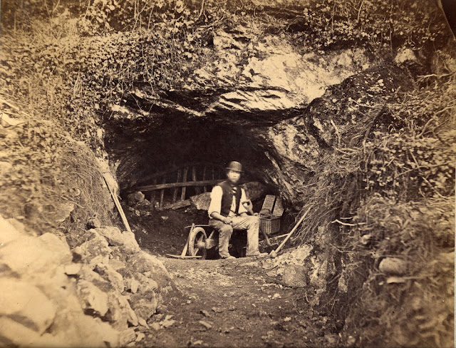
Entrance to Kent's Cavern. 1890. Photograph by William Whitaker.
BGS image ID: P264080
George Smerdon at the entrance to Kent's Cavern. 1890. Photograph by William Whitaker.
George was the Site Foreman at the cave and undertook the excavation under William Pengelly and his decendents still manage Kent's Cavern today!  We have had confirmation that this picture is reversed.


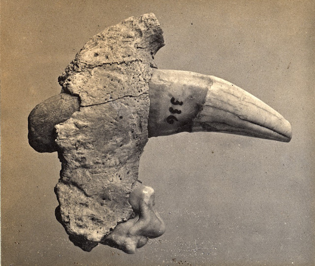
Cave Lion tooth from Kent's Cavern.Photograph by A.R. Hunt, 1891.
BGS image ID: P232130
Cave Lion tooth from Kent's Cavern. Photograph by A.R. Hunt, 1891.

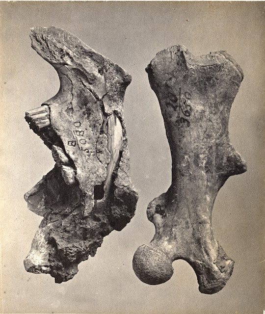
Beaver bones, Kent's Cavern.  Photograph by A.R. Hunt, 1891.
BGS image ID:  P232129
Beaver bones, Kent's Cavern. Photograph by A.R. Hunt, 1891.

Canine teeth of Wolf, Hyaena and Machairodus. Kent's Cavern.  Photograph by A.R. Hunt, 1897.
BGS image ID: P232114
Canine teeth of Wolf, Hyaena and Machairodus. Kent's Cavern. Photograph by A.R. Hunt, 1897.

For information on the British Association for the Advancement of Science photograph collection see:

Historical geological photograph collections at the British Geological Survey. In: Edinburgh Geologist Issue 53 March 2013.

Bob McIntosh


Sunday 26 May 2013

Ben Peach field notebook sketch

Ben Peach field notebook sketch. Can anyone decipher the writing?
BGS image ID: P622844
Ben Peach field notebook sketch. Can anyone decipher the writing? 

Peach was a Geological Survey of Great Britain and Ireland (now British Geological Survey) geologist whose detailed mapping with John Horne unravel the third major Nineteenth Century geological controversy, that of the structure and ages of the rocks in the North-West Highlands of Scotland. He was also a very good artist in the romantic Victorian tradition and his notebooks and back of fieldslips contain may sketches and paintings of landscapes and trees. In addition many sketches of any other things he saw around him, and cows, sheep, cats, dogs and people are portrayed often with a mischievous sense of humour. 

About Ben Peach on the British Geological Survey: Discovering Geology 

Bob McIntosh

Saturday 25 May 2013

The Carrington event, the largest magnetic storm on record. August 27th to September 7th, 1859

The Carrington event - the largest magnetic storm on record. August 27th to September 7th, 1859. Recorded at Greenwich Observatory, London.
BGS Magnetogram image ID 188878
The Carrington event - the largest magnetic storm on record. August 27th to September 7th, 1859. Recorded at Greenwich Observatory, London.

The event was responsible for a great auroral storm. The following is an eyewitness account from a woman on Sullivan's Island, Carolina and reported in the Charleston Mercury:

“The eastern sky appeared of a blood red color. It seemed brightest exactly in the east, as though the full moon, or rather the sun, were about to rise. It extended almost to the zenith. The whole island was illuminated. The sea reflected the phenomenon, and no one could look at it without thinking of the passage in the Bible which says, ‘the sea was turned to blood.’ The shells on the beach, reflecting light, resembled coals of fire.”

BGS has scanned its full collection of 300,000 magnetograms. Full resolution images can be found at http://www.bgs.ac.uk/data/magnetograms/

Bob McIntosh

Friday 24 May 2013

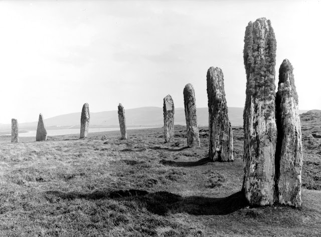
Ring of Brodgar, Stenness. Orkney Isles.

The Ring of Brodgar is a stone circle enclosed by a ditch, and occupies a commanding position on a narrow strip of land between the lochs of Stenness and Harray, in the heart of the Orkney mainland. This is a close-up view of several of the standing stones, some of which may have been cut out of the underlying bed-rock, when the ditch was constructed. The surrounding ditch was originally as much as 3 m. deep in some places.
BGS image ID: P000533
Ring of Brodgar, Stenness. Orkney Isles.

The Ring of Brodgar is a stone circle enclosed by a ditch, and occupies a commanding position on a narrow strip of land between the lochs of Stenness and Harray, in the heart of the Orkney mainland. This is a close-up view of several of the standing stones, some of which may have been cut out of the underlying bed-rock, when the ditch was constructed. The surrounding ditch was originally as much as 3 m. deep in some places.

Date of photograph 1930.

Bob McIntosh

Thursday 23 May 2013

Letter from Marie Stopes

Letter from Marie Stopes
BGS imageID: P826247
Although she is best remembered today as an advocate of birth control and women's rights Marie Charlotte Carmichael Stopes (1880-1958) was also a palaeobotanist. In this letter she is requesting samples of Tasmanite and "White Coal".

Andrew L Morrison

Leading ladies - 1912 GA Field Excursion to Leith Hill

Leading ladies -  1912 GA Field Excursion to Leith Hill. From the Geologists' Association 'Carreck Archive'

Leading ladies - 1912 GA Field Excursion to Leith Hill. From the Geologists' Association 'Carreck Archive'

Bob McIntosh

Wednesday 22 May 2013

Photograph from the Henry Mowbray Cadell Photographic archive. Russia.


Photograph from the Henry Mowbray Cadell Photographic archive c. 1902-1910 Russia.

The person on the left looks like Ben Peach of the Geological Survey of Scotland.  Does anyone know who the geologist is on the right and the possible location of the photograph?

Bob McIntosh

Thanks to Max Barclay and Svetlana Nikolaeva from International Commission of Zoological Nomenclature we have an identification of the geologist on the right: Theodosius Nikolaevich Chernyshev (12 September 1856 - 2 January 1914).

Locality is Krestovyi mountain pass in the Caucasus (Ossetia, Northern Georgia).


Tuesday 21 May 2013

Specimens from the Robert Kidston photograph collection

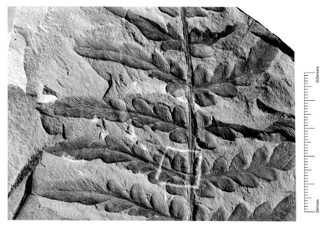
Neuropteris obliqua (Brongniart). Kidston negative number: Kidston 1246. Quarter plate. Box 3.
BGS image ID: P687055
Neuropteris obliqua (Brongniart). Kidston negative number: Kidston 1246. Quarter plate. Box 3. 
Lepidodendron veltheimianum Sternberg. Kidston negative number: Kidston 38.  Half plate. Box 1  1899
BGS image ID: P685913
Lepidodendron veltheimianum Sternberg. Kidston negative number: Kidston 38. Half plate. Box 1  1899

The Kidston Collection of fossil plants is one of the finest in the world with over 7,000 specimens including many Type and Figured specimens. Some were collected by Kidston himself and others carefully chosen from other collectors over a period of 50 years. The collection was bequeathed to the Geological Survey and Museum (now British Geological Survey). In addition to the actual specimens, Kidston created a large photograph collection of c. 4000 glass negatives of selected specimens which are also housed in BGS. They were recently scanned and are now available on the BGS image resource Geoscenic.

In 2012, the whole Kidston Collection of specimens underwent new digital photography. The specimen names are being checked and revised when appropriate. The full collection of new photography will be made available c. 2014.

Bob McIntosh


Monday 20 May 2013

Photograph from the Henry Mowbray Cadell photograph collection. Egypt. c 1902

Photograph from the Henry Mowbray Cadell photograph collection. Egypt. c 1902.  Probably the opening of the Old Aswan Dam or Aswan Low Dam, built 1902. Can anyone confirm this?
BGS image ID: P768876
Photograph from the Henry Mowbray Cadell photograph collection. Egypt. c 1902.

Probably the opening of the Old Aswan Dam or Aswan Low Dam, built 1902. Can anyone confirm this?

Bob McIntosh

Sunday 19 May 2013

'Pennyworths of Science' - Popular science communication - Museum of Practical Geology 1857


Professor Richard Owen lecturing at the Museum of Practical Geology 1857. Image from Illustrated London News. 

The tiered lecture room at the Jermyn Street Museum was a popular venue in Victorian London and was considered to hold an audience of 600 for a series of 'penny lectures' - evening Lectures to Working Men. The 'penny lectures' lasted from 1851 to at least the end of the century. The Daily Mail of 1897 described them as' popular' - 'six lectures for sixpence' and called them 'pennyworths of science'. A typical enrollment in a year was over eighteen hundred. Some enrollment lists still exist and show the audience being numerous tailors, carmen, gilders, carvers, bag makers etc.

Syllabus for 1851-1852

Why fossils are collected by Professor J.W. Jukes
The utility of geological maps by A.C. Ramsay
Mode of occurrence of metals in nature by W.W. Smyth
On iron by J. Percy
Photography by Professor R. Hunt 

The lecture room was also used for the Metropolitan School of Science Applied to Mining and the Arts (later Royal School of Mines) which was an integral part of the Geological Survey. All Geological Survey staff were involved in lecturing e.g. in 1856 Thomas Huxley gave 50 lectures on natural history, Warrington Smyth gave 60 lectures on mining and 40 on mineralogy and Ramsay lectured on geology. In that year, the whole of the 600 tickets were sold within two days indicating their popularity.

Bob McIntosh

Saturday 18 May 2013

Sketches by Ben Peach, Geological Survey of Scotland Geologist

Loch Glencoul, North-west Highlands, a watercolour sketch by Ben Peach
BGS image ID: P612884
Loch Glencoul, North-west Highlands, a watercolour sketch by Ben Peach

Before field photography was practical geologists used to create sketches like this in their notebooks and field slips.
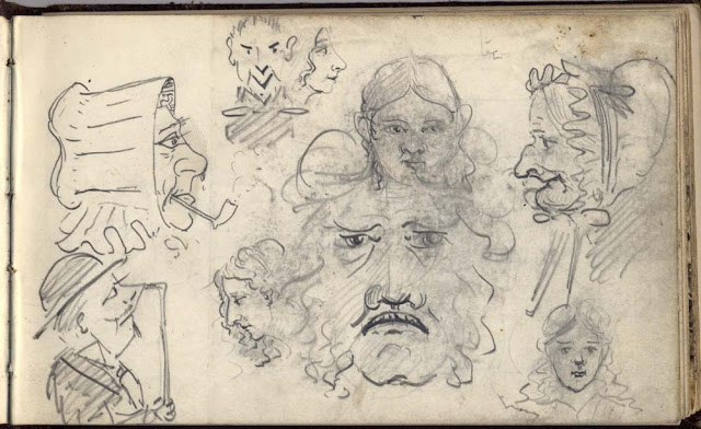
Sketch in field notebook, by Ben Peach.
BGS image ID: P612879
Sketch in field notebook, by Ben Peach. Peach would often sketch a wide range of non-geological subjects - perhaps he was sitting in a bothy somewhere waiting for the summer rain to stop, doodling faces, animals, cartoons whatever came to his mind!

Bob McIntosh

Friday 17 May 2013

Thursday 16 May 2013

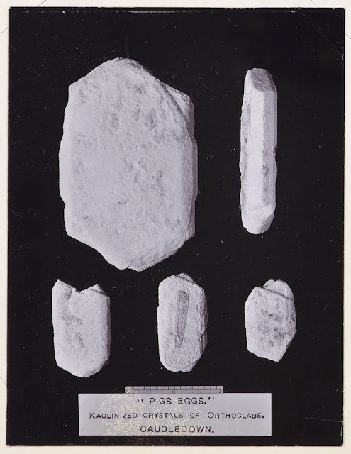
Pigs Eggs - Kaolinized Crystals of Orthoclase. Cleaves Pit, Caudledown, Cornwall.

'Pigs Ears' Kaolinized Crystals of Orthoclase. Caudledown. Geologists' Association North Cornwall Field Excursion April 16th 1914.
BGS image ID: P804217
'Pigs Eggs' Kaolinized Crystals of Orthoclase. Cleaves Pit, Caudledown, Cornwall. Geologists' Association North Cornwall Field Excursion April 16th 1914.

Today, there is a Pig's Eggs Trail

From the Geologists' Association Carreck Archive.

Bob McIntosh

Wednesday 15 May 2013

Thomas Henry Huxley

Thomas Henry Huxley
BGS image ID: P575773
Thomas Henry Huxley (1825-1895) is best remembered today for his enthusiastic support for Darwin's theory of evolution which resulted in him being called "Darwin's Bulldog". Huxley was Naturalist to the Museum of Practical Geology (1854-1885) and Professor of Biology to the School of Mines (1854-1895).

Andrew L Morrison

Crossing a river - E.O. Teale Collection

Survey team in dugout canoe. E.O. Teale photograph collection.
BGS image ID: P776352
Survey team in dugout canoe. E.O. Teale photograph collection.

This looks a fairly unstable mode of transport!

Bob McIntosh


Tuesday 14 May 2013

Stone mason working on a capital, Bath & Portland Stone Firms Ltd.

Stone mason at work on a capital, Bath & Portland Stone Firms Ltd., West Wells Masonry Works, Corsham.
BGS image No: P539472
Stone mason at work on a capital, Bath & Portland Stone Firms Ltd., West Wells Masonry Works, Corsham.  From the Hugh O'Neill Collection. Date: c. 1961.

Bob McIntosh

Monday 13 May 2013

Fossil wood collected by Charles Darwin

BGS image ID: P776114
This microscope slide shows a piece of fossil wood that Charles Darwin collected from the Island of Chiloe, Chile in 1834 during his voyage in HMS Beagle. It became part of the Joseph D Hooker slide collection.

Darwin wrote about Chiloe:

"In winter the climate is detestable, and in summer it is only a little better. I should think there are few parts of the world within the temperate regions where so much rain falls."

Andrew L Morrison  

Cheirlepis cummingiae Ag. from Monographie des poissons fossiles... by Louis Agassiz 1844-1845

Cheirlepis cummingiae Ag. from Agassiz, Louis. Monographie des poissons fossiles du vieux gres rouge ou systeme Devonien des Iiles Britanniques et du la Russie. Tab. 12.
BGS image ID: P741987
Cheirlepis cummingiae Ag. from Agassiz, Louis. Monographie des poissons fossiles du vieux gres rouge ou systeme Devonien des Iiles Britanniques et du la Russie. Tab. 12.


Agassiz, Louis. Monographie des poissons fossiles du vieux gres rouge ou systeme Devonien des Iiles Britanniques et du la Russie. Title page
Title page
Bob McIntosh

Saturday 11 May 2013

Der Aetna mit seiner nächsten Umgebung nach Fr. Hoffmann

Der Aetna mit seiner nächsten Umgebung nach Fr. Hoffmann  from Vulkanen-Atlas zur Naturgeschichte der Erde. [Stuttgart] [E. Schweizerbart] 1844

Der Aetna mit seiner nächsten Umgebung nach Fr. Hoffmann  from Vulkanen-Atlas zur Naturgeschichte der Erde. [Stuttgart] [E. Schweizerbart] 1844.

Bob McIntosh

Friday 10 May 2013

Puppet, Geologists' Dinner

Puppet
BGS image ID: P824223
This puppet is one of several used for the play "Only a Question of Time" by G A Kellaway which was performed at the Geologists' Dinner of 1953. The characters in the play included "Dai Atom", "Charlie Crinoid", "The Devil" and "The Survey Cat". It is thought that this particular puppet is "The Director" and was based on William Pugh who was the Director of the Geological Survey at the time.

William Pugh and others
William Pugh is in the middle (BGS image ID: P613248)
 Andrew L Morrison


Thursday 9 May 2013

Fingerprints of S S Buckman

Fingerprints of S S Buckman
BGS image ID: P824222
These are the fingerprints of Sidney Savory Buckman (1860-1929). They were found in an envelope marked "Finger Prints of Family" which also contained the fingerprints of his wife and children. It is possible that he was trying to see if people who were related had similar fingerprints.

Buckman was a geologist who also had a career as a novelist, commercial writer and fossil dealer to fund his geological work. He had an interest in many things including language and social and political reform.

Part of the S S Buckman collection at BGS Archives.

Andrew L Morrison

Wednesday 8 May 2013

Wynne Slate Quarry, Glyn-Ceiriog, Denbighshire. Interior view. A sawing-table.

Wynne Slate Quarry, Glyn-Ceiriog, Denbighshire. Interior showing a sawing-table. The quarry was last worked in 1928.
BGS image ID: P203057
Wynne Slate Quarry, Glyn-Ceiriog, Denbighshire. Interior showing a sawing-table. The quarry was last worked in 1928.

A really useful history can be found here: The Wynne Slate QuarryGlyn Ceiriog by J. G Isherwood

Photograph from the BGS A Series Collection: A3109. Date: 1925.

Bob McIntosh

Tuesday 7 May 2013

SILEX Ichthyopthalmus. Ichthyopthalmite. Plate no. 520. From: Sowerby, James. 1802-1817. British Mineralogy

SILEX Ichthyopthalmus. Ichthyopthalmite.  Location: Strontian. Plate no. 520. From: Sowerby, James. 1802-1817. British Mineralogy: Or Coloured figures intended to elucidate the mineralogy of Great Britain. Plate from vol: 5. page no.225.
BGS image ID: P705146
SILEX Ichthyopthalmus. Ichthyopthalmite.  Location: Strontian. Plate no. 520. From: Sowerby, James. 1802-1817. British Mineralogy: Or Coloured figures intended to elucidate the mineralogy of Great Britain. Plate from vol: 5. page no.225.

Bob McIntosh

Sunday 5 May 2013

Culbin sand-hills. Morayshire, 1912

Culbin sand-hills. Morayshire. Sand-hills. Old land surface on the left is swept clear of advancing sand. The sand-drift is from right to left due to the prevailing winds, i.e. from west to east.
BGS image ID: P000272
Culbin sand-hills. Morayshire. Sand-hills. Old land surface on the left is swept clear of advancing sand. The sand-drift is from right to left due to the prevailing winds, i.e. from west to east. The Culbin sand-hills covered an area amounting to six square miles extending from Low Wood to the mouth of the River Findhorn. Along the centre of the tract was a series of bare dome-shaped hills of sand rising to over 100 feet. Since this series of photographs the sands have been stabilized by afforestation and now most of the Culbin Sands area is a thriving forest under the care of the Forestry Commission and is designated a SSSI (Site of Special Scientific Interest).

BGS Old photograph number: B00794. Glass full plate negative

Date of photograph: 1912 

Photographer: R. Lunn

Bob McIntosh

Saturday 4 May 2013

Sandstone cast of Lepidodendron trunk, Garden of Dalclathie, Manse Road, Kilsyth, Stirlingshire

Sandstone cast of Lepidodendron trunk, Garden of Dalclathie, Manse Road, Kilsyth, Stirlingshire
BGS image ID: P002561
Garden of Dalclathie, Manse Road, Kilsyth, Stirlingshire. Sandstone cast of Lepidodendron trunk, said to be derived locally from the Limestone Coal Formation. Originally, the tree would have fallen over and been surrounded by sand which filled the hollow rotted out core of the trunk and preserved its shape. Trees such as these Lepidodendrons contributed most of the carbonaceous material which accumulated to form the coal seams in the Carboniferous. The trees grew in tremendous profusion in the moist sub-tropical climate enjoyed by Scotland at that time.

BGS old photograph No: C04090

Date of photograph: 1954

Bob McIntosh

Friday 3 May 2013

St Mary's Church, Purton, Wiltshire

St Mary's Church, Purton, Wiltshire. Looking north-west. This Norman / Medieval church with its spire and crossing tower is constructed of Jurassic Coral Rag limestones.
BGS image ID: P210855
St Mary's Church, Purton, Wiltshire. Looking north-west. This Norman / Medieval church with its spire and crossing tower is constructed of Jurassic Coral Rag limestones. The term Rag refers to the coarse grained shelly (or ragged nature) of the limestone when fractured. The ragstone beds are generally very hard and durable stones but are consequently, therefore, very difficult to work, commonly they are used as undressed rubblestone blocks. This church at Purton is largely built of local 'Coral Rag' Limestone from the local Osmington Oolite Formation.The roof of the church is covered with stone slates which in this area are likely to be from the Forest Marble Formation, although some use of local Purbeck limestones is also known. The hard, pale grey, coarsely oolitic and shelly limestones of the Corallian Group were widely used in buildings along their outcrops in Dorset, Wiltshire and Oxfordshire.

Date taken: 1967

BGS old photograph No. A11054

Bob McIntosh

Thursday 2 May 2013

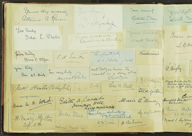
Page of signatures of Geological Survey of Great Britain staff. From the Geologists' Association 'Carreck Archive'

Page of signatures of Geological Survey of Great Britain staff. From the Geologists' Association 'Carreck Archive'.

Page of signatures of Geological Survey of Great Britain staff. From the Geologists' Association 'Carreck Archive'.

The GA albums contain many pages of signatures of members, an archivist's delight!

Bob McIntosh

Wednesday 1 May 2013

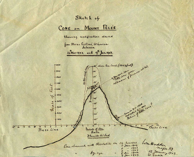
Sketch of the cone on Mount Pelée


Sketch of the cone on Mount Pelée
BGS image ID: P823786
 This sketch of the cone of the volcano Mount Pelée on Martinique was sent to John Flett who at the time was a Geologist at the Geological Survey. The creator of the sketch has written his name on the bottom right-hand side. It is not clear but could be W M Hadden, Major RE [Royal Engineers].

The eruption of Mount Pelée in May 1902 killed around 30,000 people and volcanic activity continued until 1905.

Andrew L Morrison

The Inaccessible Pinnacle, Sgurr Dearg, west side. Skye. Abraham Brothers.

The Inaccessible Pinnacle, Sgurr Dearg, west side. Skye. Date of image: c. 1892.
BGS image ID: P224572
The Inaccessible Pinnacle, Sgurr Dearg, west side. Skye. Date of image: c. 1892.

From an Abraham Brothers photographic print. BGS Archives.