Showing posts with label photograph. Show all posts

Wednesday, 28 January 2015

Photograph from the Frederic William Harmer collection. Above Runton Gap

Above Runton Gap, 3rd October 1907.  Two names noted Gottsche and Tietze. Photograph from the Frederic William Harmer collection.
BGS Image ID: P680269

Above Runton Gap, Norfolk, 3rd October 1907.  Two names noted Gottsche and Tietze. Photograph from the Frederic William Harmer collection.

Runton is the main outcrop of the type deposit of the Cromerian warm stage  the West Runton Freshwater Bed. The latter is highly fossiliferous containing remains of plants and trees, molluscs, fish, amphibians, large and small mammals and birds.

Probably Carl Christian Gottsche and Emil Ernst August Tietze, can anyone confirm?

Posted by Bob McIntosh

Monday, 19 May 2014

Louis Bernacchi notebook. British National Antarctic Expedition, 1901–04


Photographs from the 'Pendulum observations' notebook by Louis Bernacchi from the 'Discovery' Antarctic Expedition 1902-1903. Bernacchi was recruited as physicist for Captain R.F. Scott's British National Antarctic Expedition (1901-04).

This journal records Pendulum Observations and includes certificates and notes.  The two photographs show the interior of a hut in 1902 with the pendulum apparatus within it. The photographs are annotated with details of the equipment. The image also includes other items held in the hut, including snow shoes, a kettle and an appetizing looking crate of ‘Special Cabin Biscuits’.


Title page of Bernacchi's Pendulum observations notebook.


Sample page from Bernacchi's Pendulum observations notebook.

Pendulum observations were undertaken within a vacuum apparatus to determine the local value of gravity which helps indicate the extent to which the earth is oblate. There were three pendulums and each observation took many hours.


Posted by Fiona Menzies and Bob McIntosh

Tuesday, 24 December 2013

Iguanodon, Elephant, Bison, Rhinoceros and other saurian remains 1911.

Thigh bone of Iguanadon, Wealden Beds, Brook, Isle of Wight. E.T. Martin

Thigh bone of Iguanodon, Wealden Beds, Brook, Isle of Wight. E.T. Martin.


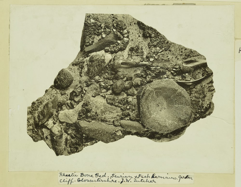
Rhaetic Bone Bed. saurian and fish remains. Garden Cliff. Gloucestershire. J.W. Fletcher.

Rhaetic Bone Bed. saurian and fish remains. Garden Cliff. Gloucestershire. J.W. Fletcher.

Elephant and Rhinoceras. Barrington Beds. Cambridgeshire. H.M. Krusin 15.6.1911

Elephant and Rhinoceros. Barrington Beds. Cambridgeshire. H.M. Krusin 15.6.1911

Bison, Elephant and Rhinoceras, barrington beds. Barrington Cambridgeshire 15.6.1911

Bison, Elephant and Rhinoceros, Barrington Beds. Barrington Cambridgeshire 15.6.1911

Images from the Geologists' Association 'Carreck Archive' held at the British Geological Survey

Bob McIntosh

Friday, 24 May 2013

Ring of Brodgar, Stenness. Orkney Isles.

The Ring of Brodgar is a stone circle enclosed by a ditch, and occupies a commanding position on a narrow strip of land between the lochs of Stenness and Harray, in the heart of the Orkney mainland. This is a close-up view of several of the standing stones, some of which may have been cut out of the underlying bed-rock, when the ditch was constructed. The surrounding ditch was originally as much as 3 m. deep in some places.
BGS image ID: P000533
Ring of Brodgar, Stenness. Orkney Isles.

The Ring of Brodgar is a stone circle enclosed by a ditch, and occupies a commanding position on a narrow strip of land between the lochs of Stenness and Harray, in the heart of the Orkney mainland. This is a close-up view of several of the standing stones, some of which may have been cut out of the underlying bed-rock, when the ditch was constructed. The surrounding ditch was originally as much as 3 m. deep in some places.

Date of photograph 1930.

Bob McIntosh

Wednesday, 22 May 2013

Photograph from the Henry Mowbray Cadell Photographic archive. Russia.


Photograph from the Henry Mowbray Cadell Photographic archive c. 1902-1910 Russia.

The person on the left looks like Ben Peach of the Geological Survey of Scotland.  Does anyone know who the geologist is on the right and the possible location of the photograph?

Bob McIntosh

Thanks to Max Barclay and Svetlana Nikolaeva from International Commission of Zoological Nomenclature we have an identification of the geologist on the right: Theodosius Nikolaevich Chernyshev (12 September 1856 - 2 January 1914).

Locality is Krestovyi mountain pass in the Caucasus (Ossetia, Northern Georgia).


Tuesday, 21 May 2013

Specimens from the Robert Kidston photograph collection

Neuropteris obliqua (Brongniart). Kidston negative number: Kidston 1246. Quarter plate. Box 3.
BGS image ID: P687055
Neuropteris obliqua (Brongniart). Kidston negative number: Kidston 1246. Quarter plate. Box 3. 
Lepidodendron veltheimianum Sternberg. Kidston negative number: Kidston 38.  Half plate. Box 1  1899
BGS image ID: P685913
Lepidodendron veltheimianum Sternberg. Kidston negative number: Kidston 38. Half plate. Box 1  1899

The Kidston Collection of fossil plants is one of the finest in the world with over 7,000 specimens including many Type and Figured specimens. Some were collected by Kidston himself and others carefully chosen from other collectors over a period of 50 years. The collection was bequeathed to the Geological Survey and Museum (now British Geological Survey). In addition to the actual specimens, Kidston created a large photograph collection of c. 4000 glass negatives of selected specimens which are also housed in BGS. They were recently scanned and are now available on the BGS image resource Geoscenic.

In 2012, the whole Kidston Collection of specimens underwent new digital photography. The specimen names are being checked and revised when appropriate. The full collection of new photography will be made available c. 2014.

Bob McIntosh


Monday, 20 May 2013

Photograph from the Henry Mowbray Cadell photograph collection. Egypt. c 1902

Photograph from the Henry Mowbray Cadell photograph collection. Egypt. c 1902.  Probably the opening of the Old Aswan Dam or Aswan Low Dam, built 1902. Can anyone confirm this?
BGS image ID: P768876
Photograph from the Henry Mowbray Cadell photograph collection. Egypt. c 1902.

Probably the opening of the Old Aswan Dam or Aswan Low Dam, built 1902. Can anyone confirm this?

Bob McIntosh

Saturday, 4 May 2013

Sandstone cast of Lepidodendron trunk, Garden of Dalclathie, Manse Road, Kilsyth, Stirlingshire

Sandstone cast of Lepidodendron trunk, Garden of Dalclathie, Manse Road, Kilsyth, Stirlingshire
BGS image ID: P002561
Garden of Dalclathie, Manse Road, Kilsyth, Stirlingshire. Sandstone cast of Lepidodendron trunk, said to be derived locally from the Limestone Coal Formation. Originally, the tree would have fallen over and been surrounded by sand which filled the hollow rotted out core of the trunk and preserved its shape. Trees such as these Lepidodendrons contributed most of the carbonaceous material which accumulated to form the coal seams in the Carboniferous. The trees grew in tremendous profusion in the moist sub-tropical climate enjoyed by Scotland at that time.

BGS old photograph No: C04090

Date of photograph: 1954

Bob McIntosh

Thursday, 25 April 2013

Whitby Harbour, by W.J. Harrison, 1897.

Whitby Harbour, by W.J. Harrison, 1897.
BGS image ID: P243580
Whitby Harbour, by W.J. Harrison, 1897.

The image is from the British Association for the Advancement of Science photograph collection. This collection of over 7,000 photographs is held in the British Geological Survey Archive.

The BAAS collection has had an interesting history. In 1888, O.J. Jeffs proposed to the BAAS that they should address the need for systematic photographic coverage of the geology of the United Kingdom. His proposal was accepted and the BAAS set up a committee under the chairmanship of James Geikie, for the ‘collection, preservation and systematic registration of photographs of geological interest in the United Kingdom’. This was how the collection began.

The collection was first housed in the Geological Survey Museum and Library in Jermyn Street, London and then moved to the new new premises in Exhibition Road. During the Second World War the glass plates were moved 'for safety' to Bristol where unfortunately they were totally destroyed during an air raid, the prints still housed in Exhibition Road remained undamaged.

Bob McIntosh

Monday, 15 April 2013

Geologists' Association Field trip - Oswestry 1908 - group photograph


Geologists' Association  - Oswestry  Excursion, 1908 - group photograph. Photograph from the GA 'Carreck Archive'


Geologists' Association  - Oswestry  Excursion, 1908 - index to people in the group photograph. Photograph from the GA 'Carreck Archive'

Geologists' Association  - Oswestry  Excursion, 1908 - group photograph. Photograph from the GA 'Carreck Archive'

Bob McIntosh

Thursday, 11 April 2013

Stoop and room, Middleton Quarry and Mine, Gorebridge. Midlothian.

Middleton Quarry and Mine, Gorebridge. Midlothian. Stoop and room (pillar and stall) is an old method of mining where the material, in this case limestone is extracted leaving pillars of limestone in place to support the roof.
BGS image ID: P000178
Middleton Quarry and Mine, Gorebridge. Midlothian.

Stoop and room (pillar and stall) is an old method of mining where the material, in this case limestone is extracted leaving pillars of limestone in place to support the roof.

Interior view of the mine illustrating the method of extraction. A figure in the centre of the image illustrates the scale. Mining the North Greens (No. 2) Limestone. The thickness of the seam is 50 ft. though only the lower 20 ft. is in massive beds and suitable for mining. Chemical analysis shows it is 94.09% calcium carbonate and is of uniform high quality. The limestone was burnt in vertical, continuous mixed-feed kilns to produce lime for both agriculture and building purposes. Ground limestone was also produced. The rocks are of the Lower Limestone Group of the Carboniferous period. The quarry is now disused.

Date of image: 1945.

Bob McIntosh

Tuesday, 9 April 2013

Mica processing at the Pitlochry Depot, Perthshire. 1945.


Processing of Scottish mica. Pitlochry Depot (January 1945). Perthshire. Cutting and trimming mica at the Sorting Factory.
BGS image ID: P000163
Processing of Scottish mica. Pitlochry Depot (January 1945). Perthshire. Cutting and trimming mica at the Sorting Factory.

The split mica sheets are trimmed of all flaws, structural imperfections or, less serious, inclusions. The cutting knife is held at a low angle to the cleavage so the plates are consequently bevelled. The workers can clearly be seen using their knives. Processing of mica involved three stages, 1. rough cobbing, 2. splitting, 3. trimming. It does not undergo any other process of treatment or concentration before it is ready for use.


Processing of Scottish mica. Pitlochry Depot (January 1945). Perthshire. Plates of mica illustrating the various commercial grades.
BGS image ID: P000185
Plates of mica illustrating the various commercial grades. 

The photograph shows eight grades of mica. One to four are grades of staining. Five to seven are grades of spotting. Eight is a mica showing zoning, a structural imperfection. Note the re-entrant angles on three and four where imperfections have been cut out. Mica is graded for commercial purposes according to type, colour and freedom from staining. The primary division is into Muscovite or White Mica and Phlogopite or Amber Mica. Muscovite is subdivided into two types 'Ruby' and 'Green' types. Both are colourless when less than 0.5 mm. but when greater than this size they have reddish and greenish tinges respectively.

Production from the Pitlochry factory totalled 7,122 lbs. of block mica in addition 85 tons of scrap mica, resulting from the dressing operations, was sold. Mica, during wartime, became a mineral of high strategic value, an essential war material which due to its unique physical properties rendered it indispensable as an insulating medium in the manufacture of many types of electrical, radio and telephone equipment.

Bob McIntosh

Sunday, 7 April 2013

Descending a denehole at Hangman's Wood, West Thurrock, Essex.

Descending a Denehole at Hangman's Wood at West Thurrock, Essex. 1908. From the GA 'Carreck Archive'
BGS Image ID: P805290

Descending a Denehole at Hangman's Wood at West Thurrock, Essex. 1908. From the GA 'Carreck Archive'

'In the course of ploughing this field the horse's feet broke through the surface. We procured a rope and the pole of a waggon and investigated the interior. The shaft descended through about 12 feet of Thanet Sand and entered into a beehive-shaped chamber about 20 ft. high. These deneholes were formed in getting the chalk in past ages for marling the land.'

Deneholes are typically about 60 feet deep with steps cut into the side of the shaft to allow climbing in and out. At the bottom they open out to a domed chamber, often with sub-chambers.

It is though that chalk was mined this way from pre-Roman times.

Photographer: T.W. Reader

Bob McIntosh

Saturday, 6 April 2013

Geologists' Association Excursion to Derbyshire, August 3rd 1914. Bonsall.

Group photograph, Geologists' Association Excursion to Derbyshire, August 3rd 1914. Bonsall.
BGS Image ID: P804358
Group photograph, Geologists' Association Excursion to Derbyshire, August 3rd 1914. Bonsall.

From the Geologists' Association 'Carreck Archive' currently being digitized at the British Geological Survey.

Bonsall is an old mining town. Lead was mined there and in nearby Wirksworth from Roman times. The market cross is medieval and is the tallest market cross in Derbyshire. John Wesley, founder of the Methodist movement preached from the top step. The King's Head public house on the far right dates back to 1677.

Bob McIntosh

Friday, 5 April 2013

Hantergantick Quarry, Cornwall. Thermal lance demonstration.

Hantergantick Quarry, Cornwall. Thermal lance demonstration.
BGS image ID: P539881
Hantergantick Quarry. Jet cutting demonstration using a thermal lance to cut granite with heat and sound energy. Early 1960s. Note gas cylinders in the background. Hugh O'Neill Collection.

The temperature is believed to reach 3000 degrees C.

Bob McIntosh

Wednesday, 3 April 2013

Three Vickers Victoria aircraft unloading cargo. Royal Air Force at Dodoma, 1929.


Royal Air Force at Dodoma. Three Vickers Victoria aircraft unloading cargo, 1929. E.O. Teale photograph collection.
BGS image ID: P776210
Royal Air Force at Dodoma. Three Vickers Victoria aircraft unloading cargo, 1929. E.O. Teale photograph collection.

Bob McIntosh

Sunday, 31 March 2013

Tufa eggs for Easter, Matlock Bath, Derbyshire

 Tufa Easter eggs, Derbyshire

Birds nest and eggs encrusted in tufa, Matlock Bath, Derbyshire. Photograph from the Geologists' Association 'Carreck Archive'

Original description: 'Tufa which also goes by the name of Travertin [Travertine] or Calcareous Sinter is a deposit of Carbonate of Lime thrown down by springs which flow through beds of limestone. In this case at Matlock these specimens are from lime obtained from the Carboniferous Limestone. The rain in passing through the atmosphere takes up Carbonic acid and assisted by humic acid from the soil when it sinks into the limestone dissolves portions of it away. When it comes to the surface again in the form of springs it loses some of the Carbonic acid and the lime is thrown down in the form of tufa and incrusting any object that happens to be present.'

T.W. Reader photograph album. Derbyshire, August 3rd 1914.

Bob McIntosh

Saturday, 23 March 2013

Geological Survey of Scotland staff on the steps of Sherriff Court, Edinburgh


Geological Survey of Scotland staff on the steps of Sherriff Court, Edinburgh
BGS image ID: P008688
Early group photograph, Geological Survey of Scotland staff, from left to right H. Miller, B.N. Peach, W. Gunn, L.W. Hinxman, [Unknown]  sitting on steps, unknown.

Geological Survey of Scotland staff on the steps of Sherriff Court, Edinburgh
BGS image ID: P008720
Later group photograph of eight Geological Survey of Scotland staff including H. Miller, L.W. Hinxman, B.N. Peach, J. Horne and J. Dakyns. 

These two photographs were taken on the steps of Sherriff Court in Edinburgh, the home to the Geological Survey of Scotland between 1879 and 1906. Perhaps these two pictures were taken on those two dates. The third photograph: The other residents!
 Sherriff's Court, Edinburgh. The Sherriff's attendants in full regalia.
BGS image ID: P008690
Sharing the offices with the Geological Survey at Sherriff Court, Edinburgh were the Sherriff's attendants in full regalia - I wonder if this was everyday dress for them.

Bob McIntosh

Friday, 22 March 2013

Time for a haircut. Edmund O. Teale.

Mrs Charlotte Teale trims Edmund Teale's hair. Geological field camp, Portuguese East Africa. 1911. E.O. Teale photograph collection.
BGS image ID: P776550
Mrs Charlotte Teale trims Edmund Teale's hair. Geological field camp, Portuguese East Africa. 1911. E.O. Teale photograph collection.

Edmund Teale's photograph collection
Teale's collection of Geoscenic

Bob McIntosh