Showing posts with label BAAS. Show all posts

Tuesday, 7 January 2014

Aberystwyth and Borth, storm damage 28th October,1927.

Images from the British Association for the Advancement of Science Photograph Collection held at the British Geological Survey. 

Storm damage North end of Marine Terrace, Aberystwyth, 1927.
BGS Image ID: P252857 
North end of Marine Terrace, Aberystwyth


Storm damage North end of Marine Terrace, Aberystwyth, 1927.
  • BGS Image ID: P252858 
North end of Marine Terrace, Aberystwyth


Storm damage North end of Marine Terrace, Aberystwyth, 1927.
  • BGS Image ID: P252859
North end of Marine Terrace, Aberystwyth


Storm damage North end of Marine Terrace, Aberystwyth, 1927.
  • BGS Image ID: P252860
North end of Marine Terrace, Aberystwyth


Storm damage North end of Marine Terrace, Aberystwyth, 1927.
  • BGS Image ID: P252861
North end of Marine Terrace, Aberystwyth
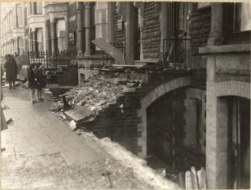

Storm damage North end of Marine Terrace, Aberystwyth, 1927.
BGS Image ID: P252862

North end of Marine Terrace, Aberystwyth
Storm damage North end of Marine Terrace, Aberystwyth, 1927.
  • BGS Image ID: P252863
North end of Marine Terrace, Aberystwyth


Storm damage south Marine Terrace, Aberystwyth, 1927.
  • BGS Image ID: P252864
South Marine Terrace, Aberystwyth


  • BGS Image ID: P252865
Borth, North of Aberystwyth


  • BGS Image ID: P252866 
Borth, North of Aberystwyth


Storm damage North end of Marine Terrace, Aberystwyth, 1927.
  • BGS Image ID: P252867
North end of Marine Terrace, Aberystwyth


Storm damage North end of Marine Terrace, Aberystwyth, 1927.
  • BGS Image ID: P252868
North end of Marine Terrace, Aberystwyth


Storm damage North end of Marine Terrace, Aberystwyth, 1927.
  • BGS Image ID: P252869
North end of Marine Terrace, Aberystwyth


Storm damage North end of Marine Terrace, Aberystwyth, 1927.
  • BGS Image ID: P252870 
North end of Marine Terrace, Aberystwyth

Victoria Terrace, Aberystwyth. Storm damage 15th January 1938.

Victoria Terrace, Aberystwyth. Effect of gale of Jan. 15, 1938.
BGS Image ID: P257998

Aberystwyth storm aftermath of 1938 recorded by British Pathe (From BBC)

 
Bob McIntosh

Sunday, 5 January 2014

Swildon's Hole, Priddy, Mendip Hills, Somerset.1921.


Tratman's Temple, Swildon's Hole, cave near Priddy, Mendips, Somerset.1921.
BGS Image ID: P249907
Tratman's Temple 

Barnes Loop. Tratman's Temple, Swildon's Hole, cave near Priddy, Mendips, Somerset.1921.
BGS Image ID: P249908
Barnes Loop

The White Way through Barnes Loop. Swildon's Hole, cave near Priddy, Mendips, Somerset.1921.
BGS Image ID: P249905
The White Way through Barnes Loop

Slender stalagmite pillars. Swildon's Hole, cave near Priddy, Mendips, Somerset.1921.
BGS Image ID: P249906
Slender stalagmite pillars [Tratman's Temple]

Images from the British Association for the Advancement of Science photograph collection held at the British Geological Survey.

Photographs were taken by J.Harry Savory in 1921. A brief account of the cave exploration at this time can be found in the recent book: Irwin, D., Moody, A., Farrant, A. Swildon's Hole: 100 years of exploration. Published by the Wessex Cave Club, 2007.

Bob McIntosh

Friday, 6 December 2013

Horsey coastal inundation, Norfolk 1938.

Horsey inundation, Norfolk. 1938.
BGS image ID: P256624
Horsey inundation 1938. Course of the 'hundred streams'.

Horsey inundation, Norfolk. 1938.
BGS image ID: P256625
Horsey inundation 1938. Looking inland from south edge of gap which finally reached length of 500 yards.

Horsey inundation, Norfolk. 1938.
BGS image ID: P256626
Horsey inundation 1938. Peat exposed in foreshore by cutting back of beach.

Horsey inundation, Norfolk. 1938.
BGS image ID: P256627
Horsey inundation 1938. View from behind temporary defences, looking seaward.

'Village of Horsey again inundated' Newspaper article 1938.

Images taken by H. Ashley. From the British Association for the Advancement of Science photograph collection. The collection is on permanent deposit with the British Geological Survey.

Historical photographs are often valuable evidence when comparing geological processes over time.

Bob McIntosh
http://www.exploreyourarchive.org/

Sunday, 23 June 2013

Here lived William Smith, Tucking Mill, Somerset in 1890.

Here lived William Smith " Father of English Geology" Born 23rd March 1769, Died 28th August 1839. Plaque on wall at Tucking Mill, Somerset.
BGS image ID: P259913
Here lived William Smith " Father of English Geology" Born 23rd March 1769, Died 28th August 1839. Plaque on wall at Tucking Mill, Somerset.
Tucking Mill, 1890
BGS image ID: P259997
Tucking Mill, 1890. The mill which was demolished in 1927.

Images are from the British Association for the Advancement of Science Photograph Collection held on deposit at the British Geological Survey.

Bob McIntosh

Wednesday, 19 June 2013

Lavernock, Images from the BAAS Collection

Penarth-Lavernock. Sections of Penarth Beds, etc., from Penarth Head to Lavernock. 1892. Photograph by C.J. Watson. From the British Association for the Advancement of Science photograph collection.
BGS image ID: P232603
Sections of Penarth Beds, etc., from Penarth Head to Lavernock. 1892. Photograph by C.J. Watson. From the British Association for the Advancement of Science photograph collection.
Lavernock Point. Lower Lias and Rhaetic shale. 1901. Photograph by S.H. Reynolds. From the British Association for the Advancement of Science photograph collection.
BGS image ID: P239939
Lavernock Point. Lower Lias and Rhaetic shale. 1901. Photograph by S.H. Reynolds. From the British Association for the Advancement of Science photograph collection.

Bob McIntosh

Thursday, 13 June 2013

Storm damage in Aberystwyth, October 28th 1927 and January 15th 1938


N. end of Marine Terrace, Aberystwyth. Effects of storm of Oct. 28th, 1927.
BGS image ID: P252861
N. end of Marine Terrace, Aberystwyth. Effects of storm of Oct. 28th, 1927.


Borth, N. of Aberystwyth. Effects of storm of Oct. 28th, 1927.
BGS image ID: P252866
Borth, N. of Aberystwyth. Effects of storm of Oct. 28th, 1927.


 Victoria Terrace, Aberystwyth. Effect of gale of Jan. 15, 1938.
BGS image ID: P257998
 Victoria Terrace, Aberystwyth. Effect of gale of Jan. 15, 1938.

All three images are from the British Association for the Advancement of Science photograph collection.


Bob McIntosh

Wednesday, 29 May 2013

Geological excursion in the North-West Highlands of Scotland. Assynt region, 1912

he British Association for the Advancement of Science Meeting, Dundee 1912. Assynt Excursion 11th 18th September 1912. Outside the Inchnadamph Hotel. Overseas participants.

The British Association for the Advancement of Science Meeting, Dundee 1912. Geological excursion in the North-West Highlands of Scotland. Assynt region conducted by B.N. Peach and John Horne. 11th 18th September 1912. Outside the Inchnadamph Hotel. Overseas participants.

From the 'Grizzly Bears' Dinner Books. 

The British Association for the Advancement of Science Meeting, Dundee 1912. Assynt Excursion 11th 18th September 1912. List of participants on the field excursion

 List of participants on the field excursion.

Bob McIntosh

Thursday, 25 April 2013

Whitby Harbour, by W.J. Harrison, 1897.

Whitby Harbour, by W.J. Harrison, 1897.
BGS image ID: P243580
Whitby Harbour, by W.J. Harrison, 1897.

The image is from the British Association for the Advancement of Science photograph collection. This collection of over 7,000 photographs is held in the British Geological Survey Archive.

The BAAS collection has had an interesting history. In 1888, O.J. Jeffs proposed to the BAAS that they should address the need for systematic photographic coverage of the geology of the United Kingdom. His proposal was accepted and the BAAS set up a committee under the chairmanship of James Geikie, for the ‘collection, preservation and systematic registration of photographs of geological interest in the United Kingdom’. This was how the collection began.

The collection was first housed in the Geological Survey Museum and Library in Jermyn Street, London and then moved to the new new premises in Exhibition Road. During the Second World War the glass plates were moved 'for safety' to Bristol where unfortunately they were totally destroyed during an air raid, the prints still housed in Exhibition Road remained undamaged.

Bob McIntosh

Sunday, 17 March 2013

The 'Drum Rock', St. Mary's, Scilly Isles. Weathering of granite.


The 'Drum Rock', St. Mary's. Scilly Isles. Weathering of granite.
BGS image ID: P241718
The Drum Rock', St. Mary's. Scilly Isles. Weathering of granite.

Dated 1895. Entry in BAAS Report for 1903. Photographer: R.H.Preston, Alverne House, Penzance. Original format: Full plate. From the British Association for the Advancement of Science (BAAS) photographic print collection.

In 1888, a photographer, O.W. Jeffs proposed to the BAAS that they should address the need for systematic photographic coverage of the geology of the United Kingdom. His proposal was accepted and the BAAS set up a committee under the chairmanship of James Geikie, for the ‘collection, preservation and systematic registration of photographs of geological interest in the United Kingdom’. The collection soon expanded and was housed in London, first in the Geological Survey and Museum Library at Jermyn Street and later at the new premises in Exhibition Road, where it complemented the Survey's own collection of photographs. The BAAS committee arranged the sale of prints and lantern slides, and every year lists of photographs were published in the BAAS Transactions.

The collection at BGS consists of over 7,000 photographs from an original total of over 9,000. Most photographs covering Ireland are held at the Ulster Museum and a few albums, Dorset, Hampshire, and Lancashire, remain unaccounted for - does anyone know where they are?

Bob McIntosh