Monday, 17 February 2014

Granite from Ailsa Craig, Scotland

Rock specimen of riebeckite granite. Ailsa Craig, Firth of Clyde, Ayrshire, Scotland.
BGS Image ID: P521397
Rock specimen of riebeckite granite. Ailsa Craig, Firth of Clyde, Ayrshire, Scotland. British Geological Survey Petrology Collection sample number EMC3360.

The sample is a pale-coloured coarse-grained igneous rock with a distinctive granitic texture. It is technically a microgranite dominated by pale alkali feldspar crystals embedded in dark riebeckite amphibole and grey quartz.  The distinctive granite of Ailsa Craig forms part of the vast Tertiary Igneous Province of northern Britain. These formed around 60 million years ago. Much of the distinctive scenery of areas such as Arran, Mull, Ardnamurchan, Rum and Skye, and the Antrim Mountains in Northern Ireland, were formed as a result of this huge outpouring of magma. Because these rocks are well exposed and preserved they have been studied in great detail by generations of geologists, and provide an opportunity to study the deeper levels or 'roots' of volcanoes, from which we can learn much about currently active volcanoes today. The riebeckite granite of Ailsa Craig forms a Tertiary granite boss rising out of the Clyde estuary. It is one of a series of Tertiary granites. This blue-grey microgranite is very distinctive and has been extensively used as a marker for tracing the flow directions of Quaternary ice-sheets.

BGS Image ID: P750285
Another specimen of granite from the Ailsa Craig Quarry. British Geological Survey Petrology Collection sample number Econ. 1166.

View of the old Ailsa Craig curling stone quarry situated on the north coast, Strathclyde Region, showing drilled-out stones 28 cm. in diameter in microgranite.
BGS IMage ID: P001614
View of the old Ailsa Craig curling stone quarry situated on the north coast, Strathclyde Region, showing drilled-out stones 28 cm. in diameter in microgranite. 

The stone has a tough fine-grained lithology and can take a very high polish. It was worked in two colours, the 'red' and 'blue' varieties, the former was rarer and was much preferred. The curling stones were the economically most significant and world-renowned resource of the island. 50 pairs were exported annually in the 1870's rising to 1000 pairs in the 1890's. The quarry restarted 1961 but becoming uneconomic closed again in 1973.

Oblique aerial view of the island of Ailsa Craig. Looking south towards the north end of the island. The island is a very prominent landmark in the Firth of Clyde formed of a microgranite boss. Ailsa Craig is formed of an arfvedsonite-aegirine-microgranite intruded by vertical dyke swarms of olivine to alkaline olivine-dolerite with basalt margins. Isotopic dating using the Rb/Sr isochron method dates the microgranite at 61.5 Ma. This makes it Tertiary in age. The remains of the castle can be seen on the skyline on the left. It was built on the orders of the Earl of Cassillis by Thomas Hamilton whose coat of arms may be seen on the walls.
BGS Image ID: P000704
BGS Old photograph number: D02015

Oblique aerial view of the island of Ailsa Craig. Looking south towards the north end of the island. The island is a very prominent landmark in the Firth of Clyde formed of a microgranite boss. Ailsa Craig is formed of an arfvedsonite-aegirine-microgranite intruded by vertical dyke swarms of olivine to alkaline olivine-dolerite with basalt margins. Isotopic dating using the Rb/Sr isochron method dates the microgranite at 61.5 Ma. This makes it Tertiary in age. The remains of the castle can be seen on the skyline on the left. It was built on the orders of the Earl of Cassillis by Thomas Hamilton whose coat of arms may be seen on the walls.

The resistance of the microgranite to erosion compared to the response to the soft Permo-Trias sandstones into which it was intruded was of crucial importance during the phase of glacial erosion. The principal direction of the ice during the last glaciation was south. This is indicated by the slight broadening of the island from north to south, albeit that this outline has been considerably modified by later marine action. The precipitous cliffs are primarily the results of marine erosion but the initiation of a strongly positive topographic feature associated with the microgranite intrusion probably occurred during glaciation.

Posted by Bob McIntosh

Sunday, 16 February 2014

Kemnay Quarries, a working granite quarry, 1939.

Kemnay Quarries. Aberdeenshire. General view of the mason's yard. Stockpiled finished stone in a variety of sizes all neatly labelled can be seen in front of the masons' sheds. A steam train is seen mounted on a light railway. In the distance is part of No. 2 Quarry with several blondins stretched across the quarry. The roofs of the sheds could open to allow the travelling steam crane to deposit stone inside for the masons to work on.
BGS Image ID: P000136
Kemnay Quarries. Aberdeenshire. General view of the mason's yard. Stockpiled finished stone in a variety of sizes all neatly labelled can be seen in front of the masons' sheds. A steam train is seen mounted on a light railway. In the distance is part of No. 2 Quarry with several blondins stretched across the quarry. The roofs of the sheds could open to allow the travelling steam crane to deposit stone inside for the masons to work on.

Kemnay Quarry, Aberdeenshire. Broken granite blocks after blast. Three quarrymen working at splitting a large block, one is wielding a pneumatic drill while the other two are using large crowbars.
BGS Image ID: P000132
Broken granite blocks after blast. Three quarrymen working at splitting a large block, one is wielding a pneumatic drill while the other two are using large crowbars.

Date of photographs: 1939.

An earlier post on Kemnay can be viewed here

Posted by: Bob McIntosh

Sunday, 9 February 2014

St. Austell Granite from Gready Quarry. 1914.

Crystals of orthoclase with inclusions of biotite


Crystals of orthoclase with inclusions of biotite
 Crystals of orthoclase with inclusions of biotite


Twinned crystal of orthoclase


 Quartz-tourmaline rock or 'stent'
 Quartz-tourmaline rock or 'stent'


Photographs are from the Geologists' Association 'Carreck Archive' held at the British Geological Survey.


Posted by Bob McIntosh

Sunday, 2 February 2014

Fossil fish from the British Geological Survey collections

Thrissops, a ray-finned fish from the Jurassic. Specimen GSM85802. Thrissops was a member of the more advanced ray-finned fish, an early teleost. It lived in the seas of many places in Europe and fossils have been found in Jurassic and Cretaceous sediments of England, France and Germany. There may be one group of living fish related to Thrissops, the freshwater 'bony tongue' such as the pirarucu which lives in the rivers of South America. Thrissops grew up to about 60 cm. in length and once swam in the late Jurassic seas of southern England, about 145 million years ago. Although not seen in the specimen illustrated, Thrissops had a large symmetrical tail which enabled the fish to swim rapidly. It had small pelvic fins, but long anal fins, which were used to stabilise it. The pectoral fins were large as can be seen in the photograph. Fish are cold-blooded vertebrates with a braincase, fins for swimming and gills to take oxygen from the water (although some also have lungs). They therefore differ from other aquatic creatures like invertebrate molluscs or crabs; amphibians and reptiles, which have lungs and limbs rather than gills and fins; and whales and dolphins which are warm-blooded mammals. Fish are the first vertebrates, having evolved during the early Cambrian over 500 million years ago.
BGS Image ID: P549484
Thrissops, a ray-finned fish from the Jurassic. Specimen GSM85802.

Thrissops was a member of the more advanced ray-finned fish, an early teleost. It lived in the seas of many places in Europe and fossils have been found in Jurassic and Cretaceous sediments of England, France and Germany. There may be one group of living fish related to Thrissops, the freshwater 'bony tongue' such as the pirarucu which lives in the rivers of South America. Thrissops grew up to about 60 cm. in length and once swam in the late Jurassic seas of southern England, about 145 million years ago. Although not seen in the specimen illustrated, Thrissops had a large symmetrical tail which enabled the fish to swim rapidly. It had small pelvic fins, but long anal fins, which were used to stabilise it. The pectoral fins were large as can be seen in the photograph. Fish are cold-blooded vertebrates with a braincase, fins for swimming and gills to take oxygen from the water (although some also have lungs). They therefore differ from other aquatic creatures like invertebrate molluscs or crabs; amphibians and reptiles, which have lungs and limbs rather than gills and fins; and whales and dolphins which are warm-blooded mammals. Fish are the first vertebrates, having evolved during the early Cambrian over 500 million years ago.

Macropoma, a coelocanth from the late Cretaceous. Specimen GSM109036. Lobe-finned fish like coelocanths are occasionally found in the late Cretaceous (about 70 million years old) Chalk of Britain and in eastern Europe. However, coelocanths then seemed to disappear from the fossil record, and it was assumed that they had become extinct. However, in 1938 a living representative was found and they have since been found living off the Comoro Islands, Indian Ocean, and off Indonesia. Macropoma grew to about half a metre long. It had a deep body and a bulbous, 3-lobed tail. Its teeth are confined to the very front of the jaw. It had two dorsal fins, a pair of pectoral fins on its side and pelvic fins mid-way along on the underside of the body. Macropoma scales are very thin, ovoid plates of fibrous bone, enamelled on the outer surface. Fish are cold-blooded vertebrates with a braincase, fins for swimming and gills to take oxygen from the water (although some also have lungs). They therefore differ from other aquatic creatures like invertebrate molluscs or crabs; amphibians and reptiles, which have lungs and limbs rather than gills and fins; and whales and dolphins which are warm-blooded mammals. Fish are the first vertebrates, having evolved during the early Cambrian over 500 million years ago.
BGS Image ID: P549485
Macropoma, a coelocanth from the late Cretaceous. Specimen GSM109036.

Lobe-finned fish like coelocanths are occasionally found in the late Cretaceous (about 70 million years old) Chalk of Britain and in eastern Europe. However, coelocanths then seemed to disappear from the fossil record, and it was assumed that they had become extinct. However, in 1938 a living representative was found and they have since been found living off the Comoro Islands, Indian Ocean, and off Indonesia. Macropoma grew to about half a metre long. It had a deep body and a bulbous, 3-lobed tail. Its teeth are confined to the very front of the jaw. It had two dorsal fins, a pair of pectoral fins on its side and pelvic fins mid-way along on the underside of the body. Macropoma scales are very thin, ovoid plates of fibrous bone, enamelled on the outer surface. Fish are cold-blooded vertebrates with a braincase, fins for swimming and gills to take oxygen from the water (although some also have lungs). They therefore differ from other aquatic creatures like invertebrate molluscs or crabs; amphibians and reptiles, which have lungs and limbs rather than gills and fins; and whales and dolphins which are warm-blooded mammals. Fish are the first vertebrates, having evolved during the early Cambrian over 500 million years ago.

A fossil specimen of Cephalaspis lyelli Agassiz. A fossil fish. (Vertebrata, Pisces.) Glammis, Perthshire, Scotland.  Cephalaspis lyelli is a jawless fish; a member of the Ostracoderms which were armoured with bony plates and scales. British Geological Survey Biostratigraphy Collection number GSM 5107. Cast of Lectotype. They occurred mainly in fresh and brackish water and were most abundant in the Lower Old Red Sandstone Devonian. Cephalaspis is one of the best known ostracoderms with the head covered by a rigid bony shield and the rest of the body by elongated scales. A pair of fins lie just behind the head shield which has the depressed shape of a bottom dweller. Cephalaspis is thought to have lived in fresh-water pools or streams feeding on organic material filtered in the gill pouches from bottom sediments. Figd. Agassig, Rech, Poiss. Foss. 2. 1838, pl. 1, fig.2, and Lankester, Mon. Pal. Soc. 1868, O.R.S. Fishes. Pl. VIII, fig. 1, & Stensio, Ceph. Great Britain 1932 B.M.(N.H.) pub. Text fig. 40, p.121. Cited Lankester, as before, p 44, and Stensio as before .
BGS Image ID: P521130
A fossil specimen of Cephalaspis lyelli Agassiz. A fossil fish. (Vertebrata, Pisces.) Glammis, Perthshire, Scotland.

 Cephalaspis lyelli is a jawless fish; a member of the Ostracoderms which were armoured with bony plates and scales. British Geological Survey Biostratigraphy Collection number GSM 5107. Cast of Lectotype. They occurred mainly in fresh and brackish water and were most abundant in the Lower Old Red Sandstone Devonian. Cephalaspis is one of the best known ostracoderms with the head covered by a rigid bony shield and the rest of the body by elongated scales. A pair of fins lie just behind the head shield which has the depressed shape of a bottom dweller. Cephalaspis is thought to have lived in fresh-water pools or streams feeding on organic material filtered in the gill pouches from bottom sediments. Figd. Agassig, Rech, Poiss. Foss. 2. 1838, pl. 1, fig.2, and Lankester, Mon. Pal. Soc. 1868, O.R.S. Fishes. Pl. VIII, fig. 1, & Stensio, Ceph. Great Britain 1932 B.M.(N.H.) pub. Text fig. 40, p.121. Cited Lankester, as before, p 44, and Stensio as before .

 A fossil specimen of Osteolepis macrolepidotus Agassiz. A fossil fish. (Vertebrata, Pisces.) Quarry below High Water Mark near Verron, Bay of Skaill, Orkney, Scotland. Osteolepis macrolepidotus is a crossopterygian fish from the Old Red Sandstone (Devonian). British Geological Survey Biostratigraphy Collection number GSE 12832. The lobe-finned fish distinguised by paired fins supported by scale-covered fleshy lobes and axial bony skeleton, and nostrils in the upper mouth include two groups, the lungfish such as Dipterus and the crossopterygians such as Osteolepis and Holoptychius. Crossopterygians were noted for their sharp pointed grasping teeth with vertically-grooved surface giving a labyrinthodont form well suited to a voracious predator such as Osteolepis. The evolution of the lobe-finned fish was one of the most important steps in the evolution of the vertebrates. Some features of Osteolepis are found in the labyrinthodont amphibians such as the ichthyostegids.
BGS Image ID: P521200
A fossil specimen of Osteolepis macrolepidotus Agassiz. A fossil fish. (Vertebrata, Pisces.) Quarry below High Water Mark near Verron, Bay of Skaill, Orkney, Scotland.

Osteolepis macrolepidotus is a crossopterygian fish from the Old Red Sandstone (Devonian). British Geological Survey Biostratigraphy Collection number GSE 12832. The lobe-finned fish distinguised by paired fins supported by scale-covered fleshy lobes and axial bony skeleton, and nostrils in the upper mouth include two groups, the lungfish such as Dipterus and the crossopterygians such as Osteolepis and Holoptychius. Crossopterygians were noted for their sharp pointed grasping teeth with vertically-grooved surface giving a labyrinthodont form well suited to a voracious predator such as Osteolepis. The evolution of the lobe-finned fish was one of the most important steps in the evolution of the vertebrates. Some features of Osteolepis are found in the labyrinthodont amphibians such as the ichthyostegids.

Posted by Bob McIntosh.

Sunday, 26 January 2014

Henry Moubray Cadell Collection. Photos from four continents.

Cadell family(?) in India
BGS Image ID: P769129
Cadell family(?) in India

Pyramids and Sphinx of Egypt
BGS Image ID: P768981
Pyramids and Sphinx of Egypt

Yosemite, in the United States of America
BGS Image ID: P768923
Yosemite, in the United States of America

Tsar Bell, Kremlin, Russia
BGS Image ID: P768832
Tsar Bell, Kremlin, Russia

Henry Moubray Cadell of Grange, FRSE (1860-1934) was a Scottish geologist and geographer.  He is known for his experiments in mountain building.The British Geological Survey holds his notebooks relating to the experiments and recreates the squeeze box experiments every year at the BGS Open Day in September. He is also known for his work on the Moine Thrust and the oli shales of the Lothians.

The British Geological Survey holds Cadell's extensive photograph collection. All are now available on Geoscenic.

Bob McIntosh

Sunday, 19 January 2014

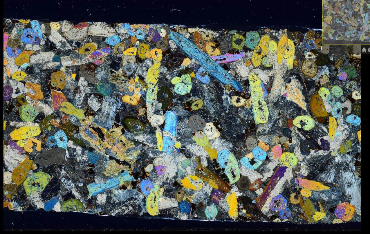
Rock thin sections from the Lugar Sill, Ayrshire.


BGS Thin section number: N10550. Lugar Drill Hole No.3, N bank of Glenmuir Water just up stream with Bellow Water, depth: from 18.8 inch section to 12ft 1 inches.

BGS Thin section number: N10550. Lugar Drill Hole No.3, N bank of Glenmuir Water just up stream with Bellow Water, depth: from 18.8 inch section to 12ft 1 inches. 


BGS Thin section number: N10554. Lugar Drill Hole No.3, N bank of Glenmuir Water just up stream with Bellow Water, depth: from 12.8 inch section to 14ft 1 inches.

BGS Thin section number: N10554. Lugar Drill Hole No.3, N bank of Glenmuir Water just up stream with Bellow Water, depth: from 12.8 inch section to 14ft 1 inches. 


The petrological thin sections (microscope slides) are being digitally photographed (plane and cross polarized light) and progressively linked to the database. Currently about 110,000 Scottish thin sections are available (220,000 images) (S & N registration series). The English collection is currently being captured and the first images will be available on Britrocks during 2014. To view others in the collection visit Britrocks, the British Geological Survey online catalogue of rock and mineral samples.

To see how the images have been captured by our team of volunteers visit this blog post on Geoblogy by Isla Simmons and Rachel Whitty.

Bob McIntosh


Thursday, 9 January 2014

Long Churn Cave, Leeds Cave Club, 1931. H.W. Haywood Collection.

Sample images from the H.W. Haywood Collection, Leeds Caving Club 1928-1934

Leeds Cave Club outside entrance. Long Churn Cave, 1931.
BGS Image ID:  P617430
Leeds Cave Club outside entrance. Long Churn Cave, 1931.

 The traverse pool and plank pool. Long Churn Cave. H.W. Haywood Collection
BGS Image ID:  P617445
 The traverse pool and plank pool.


Descent of Long Churn chimney. Long Churn Cave. H.W. Haywood Collection
BGS Image ID:  P617476
Descent of Long Churn chimney.


Plan of Long Churn Cave with Diccan and Alum Pots H.W. Haywood Collection. Leeds Cave Club.
BGS Image ID:  P617588
Plan of Long Churn Cave with Diccan and Alum Pots

Photographs from the H.W. Haywood Collection held at the British Geological Survey.

A collection of photographs depicting cave exploration and related activities in the Yorkshire Dales area by the Leeds Cave Club in the early 1930s and taken by Harold Wadsworth Haywood FRPS was donated to the Geological Survey of Great Britain Library by Miss Haywood in 1935. The collection consists of two large albums containing a total of 460 separate photographs. There are also twenty-six pages of typescript notes, a bibliography and nine pages of hand-drawn maps and sections illustrating the Alum Pot area and its caves, all produced by Eli Simpson.

The dates of the photographs range from 1928-1934. The images cover the Yorkshire Dales and adjacent areas of Lancashire and Westmorland in the west. They include surface photographs of the caves and karst features, many spectacular underground shots of the caves and their formations, and pictures of members of the Leeds Cave Club, exploring the caves and carrying out a variety of other activities on the surface.

Website for the Haywood Collection

Images on Geoscenic

Publications

Nixon, Gill. 2007 Cave and karst images: the rediscovery of an important historical record. Cave and Karst Science : Transactions of the British Cave Research Association, 33 (2). 87-88.   Download PDF

Nixon, Gillian; Lowe, David; McIntosh, Robert. 2008 The Harold Wadsworth Haywood collection of early caving photographs. [Poster] In: 19th Cave Science Symposium, Loughborough University, 8th March 2008.  Download PDF

Bob McIntosh

Tuesday, 7 January 2014

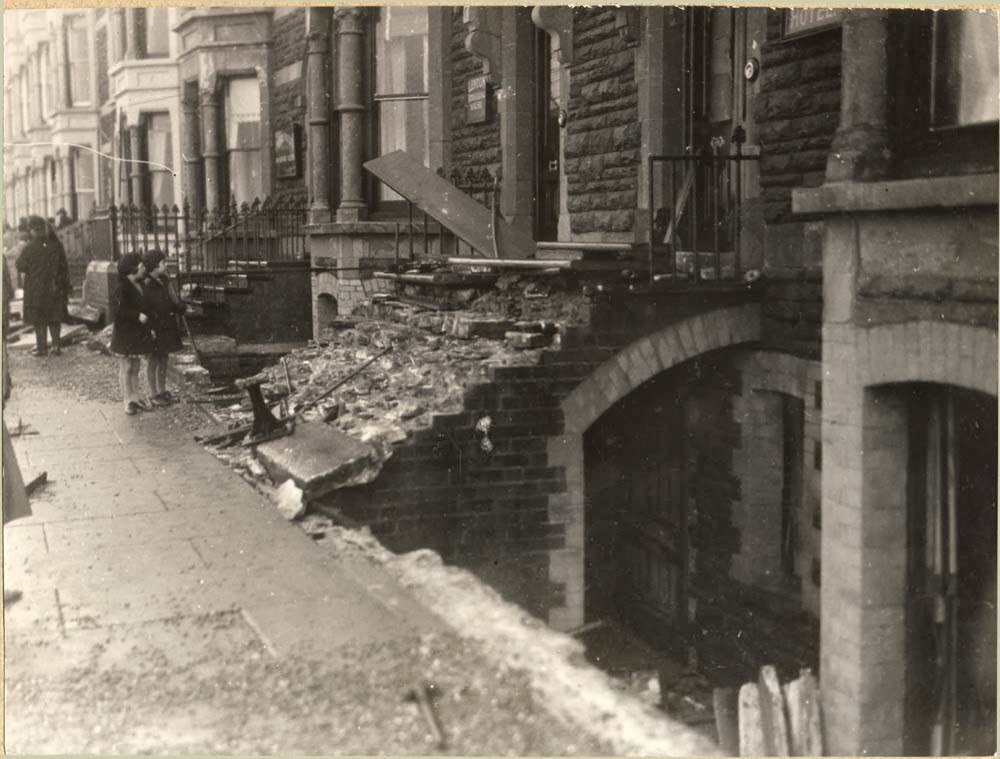
Aberystwyth and Borth, storm damage 28th October,1927.

Images from the British Association for the Advancement of Science Photograph Collection held at the British Geological Survey. 

Storm damage North end of Marine Terrace, Aberystwyth, 1927.
BGS Image ID: P252857 
North end of Marine Terrace, Aberystwyth


Storm damage North end of Marine Terrace, Aberystwyth, 1927.
  • BGS Image ID: P252858 
North end of Marine Terrace, Aberystwyth


Storm damage North end of Marine Terrace, Aberystwyth, 1927.
  • BGS Image ID: P252859
North end of Marine Terrace, Aberystwyth


Storm damage North end of Marine Terrace, Aberystwyth, 1927.
  • BGS Image ID: P252860
North end of Marine Terrace, Aberystwyth


Storm damage North end of Marine Terrace, Aberystwyth, 1927.
  • BGS Image ID: P252861
North end of Marine Terrace, Aberystwyth


Storm damage North end of Marine Terrace, Aberystwyth, 1927.
BGS Image ID: P252862

North end of Marine Terrace, Aberystwyth
Storm damage North end of Marine Terrace, Aberystwyth, 1927.
  • BGS Image ID: P252863
North end of Marine Terrace, Aberystwyth


Storm damage south Marine Terrace, Aberystwyth, 1927.
  • BGS Image ID: P252864
South Marine Terrace, Aberystwyth


  • BGS Image ID: P252865
Borth, North of Aberystwyth


  • BGS Image ID: P252866 
Borth, North of Aberystwyth


Storm damage North end of Marine Terrace, Aberystwyth, 1927.
  • BGS Image ID: P252867
North end of Marine Terrace, Aberystwyth


Storm damage North end of Marine Terrace, Aberystwyth, 1927.
  • BGS Image ID: P252868
North end of Marine Terrace, Aberystwyth


Storm damage North end of Marine Terrace, Aberystwyth, 1927.
  • BGS Image ID: P252869
North end of Marine Terrace, Aberystwyth


Storm damage North end of Marine Terrace, Aberystwyth, 1927.
  • BGS Image ID: P252870 
North end of Marine Terrace, Aberystwyth

Victoria Terrace, Aberystwyth. Storm damage 15th January 1938.

Victoria Terrace, Aberystwyth. Effect of gale of Jan. 15, 1938.
BGS Image ID: P257998

Aberystwyth storm aftermath of 1938 recorded by British Pathe (From BBC)

 
Bob McIntosh

Sunday, 5 January 2014

Swildon's Hole, Priddy, Mendip Hills, Somerset.1921.


Tratman's Temple, Swildon's Hole, cave near Priddy, Mendips, Somerset.1921.
BGS Image ID: P249907
Tratman's Temple 

Barnes Loop. Tratman's Temple, Swildon's Hole, cave near Priddy, Mendips, Somerset.1921.
BGS Image ID: P249908
Barnes Loop

The White Way through Barnes Loop. Swildon's Hole, cave near Priddy, Mendips, Somerset.1921.
BGS Image ID: P249905
The White Way through Barnes Loop

Slender stalagmite pillars. Swildon's Hole, cave near Priddy, Mendips, Somerset.1921.
BGS Image ID: P249906
Slender stalagmite pillars [Tratman's Temple]

Images from the British Association for the Advancement of Science photograph collection held at the British Geological Survey.

Photographs were taken by J.Harry Savory in 1921. A brief account of the cave exploration at this time can be found in the recent book: Irwin, D., Moody, A., Farrant, A. Swildon's Hole: 100 years of exploration. Published by the Wessex Cave Club, 2007.

Bob McIntosh

Tuesday, 24 December 2013

Iguanodon, Elephant, Bison, Rhinoceros and other saurian remains 1911.

Thigh bone of Iguanadon, Wealden Beds, Brook, Isle of Wight. E.T. Martin

Thigh bone of Iguanodon, Wealden Beds, Brook, Isle of Wight. E.T. Martin.


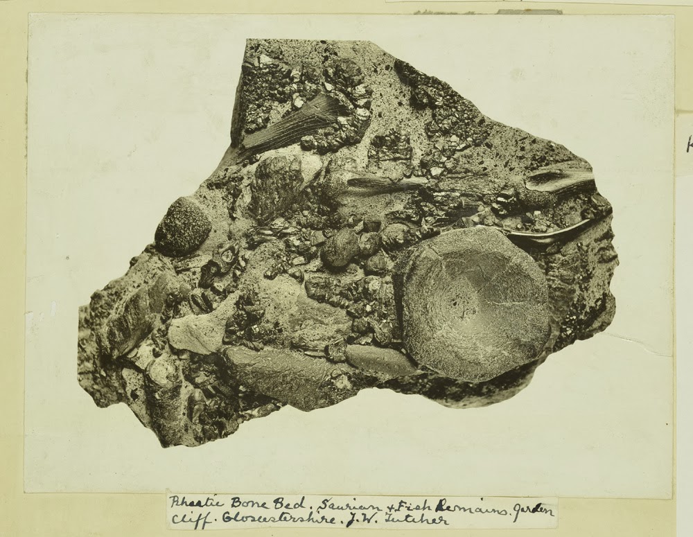
Rhaetic Bone Bed. saurian and fish remains. Garden Cliff. Gloucestershire. J.W. Fletcher.

Rhaetic Bone Bed. saurian and fish remains. Garden Cliff. Gloucestershire. J.W. Fletcher.

Elephant and Rhinoceras. Barrington Beds. Cambridgeshire. H.M. Krusin 15.6.1911

Elephant and Rhinoceros. Barrington Beds. Cambridgeshire. H.M. Krusin 15.6.1911

Bison, Elephant and Rhinoceras, barrington beds. Barrington Cambridgeshire 15.6.1911

Bison, Elephant and Rhinoceros, Barrington Beds. Barrington Cambridgeshire 15.6.1911

Images from the Geologists' Association 'Carreck Archive' held at the British Geological Survey

Bob McIntosh