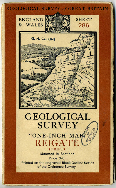
Cover for the folded sheet 286 Reigate (Drift) 1:63,360 map. 1938.
The illustration on the cover is common to all sheets issued 'mounted in sections' at that time. Does anyone know if the place depicted is a real place and if so, where it is?
Panel from sheet 286 Reigate (Drift ) 1:63,360 map. 1938. The full map can be viewed in the BGS Maps Portal.
Cover for 1:63,360 Special sheet Arran. Published 1910.The full map can be viewed in the BGS Maps Portal.
Posted by Bob McIntosh


Selling Fullz info USA UK CANADA Fresh 2025
ReplyDeleteFULLZ US + SIN/ UK + NIN/ CA + SIN
US/UK FULLZ WITH BANK INFO
SSN/SIN/NIN DOB ADDRESS PHONE EMAIL
SSN DOB DL ADDRESS EMPLOYEE & BANK INFO FULLZ USA
SIN DOB ADDRESS MMN PHONE EMAIL CANADA FULLZ
NIN DOB ADDRESS SORT CODE & ACCOUNT NUMBER FULLZ UK
REAL DL FRONT BACK WITH SELFIE & SSN USAPASSPORT PHOTOS
SPECIFIC INFO CAN BE PROVIDE AS WELL ZIP|CITIES|STATES|GENDER|BANK ETC.
BUSINESS OWNER LEADS WITH SSN
> UPDATED 100% FRESH INFO
> Accepting payment in crypto only
> Looking for good buyers who wanna do long term business with us
> I’ll give u huge discounted prices when buy in Bulk
> Checked, Updated & fresh info every day
> USA, UK (Best Seller)
Contact us at:
Whats-app – +1.. 605.. 846... 1870..
TG Chanel – t.me/bigdatatrader
Tele gram – @ Fullzpros
See you on the other side!
#USASSN #UKNIN #CanadaSIN #USAFullz #UKFullz #CanadaFullz #Payday
#Sweepstakes #EINFullz #Leadseller #Fullzseller #SSNinfo #RealSSN
#Homeowners #LoanData #USAbank #Personalinfo #usassninfo #ssndobdl
#USDT #BTC #ETH #Crypto #CVV #CC #MAGA #Bullrun
Scammed $100K by a fake Tesla group, but JetWebHackers saved me! They tracked and recovered all my money. Reach out to them at WHATSAPP: +1(763)357-2550, email: jetwebhackers@gmail.com!
ReplyDelete