Friday, 15 November 2013

China Clay works, Lantern Pit and Cleaves Pit, North Cornwall, April 16th 1914

Lantern Pit, North Cornwall, April 16th 1914
BGS Image ID: P804212
Lantern Pit, North Cornwall, April 16th 1914

Cleaves Pit, North Cornwall, April 16th 1914.
BGS Image ID: P804218
Cleaves Pit, North Cornwall, April 16th 1914.

China clay is a material called kaolin and was used to make fine white porcelain. The extraction of China clay in the St. Austell area was one of the great extractive industries in Cornwall.

Bob McIntosh

Thursday, 14 November 2013

Happy birthday - Sir Charles Lyell born 14 November 1797

Portrait, Charles Lyell, born 14 November 1797.
BGS Image ID: P517443

Charles Lyell, Bart. born 14 November 1797.

Sir Charles Lyell, a Scottish geologist was born 14 November 1797 near Kinnordy, near Kirriemuir. He was author  of 'Principles of geology', published in 1830, it was a major work at the time that supported James Hutton's view on Uniformitarianism. He was also a keen supporter of geological surveys.

The British Geological Survey (BGS) and Heriot-Watt University are joining forces to create a new centre for earth and marine science and technology. Based in Edinburgh it will be called the Sir Charles Lyell Centre and will be one of Europe's leading centres for research and expertise in the earth and marine sciences. The centre is scheduled to open by 2015.

Jointly funded by UK and Scottish funders, Natural Environment Research Council (NERC), Scottish Funding Council (SFC) and Heriot-Watt University, The Sir Charles Lyell Centre will promote innovative research at the core of geoscience, marine ecology, computing, mathematics and engineering. The Lyell Centre will create a world-leading research cluster bringing science and technology together to tackle major issues of natural resource and energy supply in a responsible and sustainable way.

Full press release on the new centre.

Bob McIntosh

Tuesday, 12 November 2013

Landslip under Southdown between Beer Headland and Branscombe 1789-80

Landslip under Southdown between Beer Headland and Branscombe which took place in 1789-90.
BGS image: P804446
Landslip under Southdown between Beer Headland and Branscombe which took place in 1789-90 looking Westward to Sidmouth Torbay and the Start Point. Artists impression filed with Excursion to Lyme Regis, June 1st 1914.

From the Geologists' Association 'Carreck Archive' on deposit at the British Geological Survey.

Does anyone have a recent picture of this spot?

Bob McIntosh

Friday, 8 November 2013

Origins of the British Geological Survey - a poster


The British Geological Survey has had a long history. Its origin was as part of the Ordnance Survey. It became a separate geological organization by 'Act of Parliament' in 1845 called the Geological Survey of Great Britain and Ireland. In 1965 it became a component institute of Natural Environment Research Council and the survey changed its name to Institute of Geological Sciences. There was a great expansion, it incorporated the Overseas Geological Survey which had it origins in the earlier Imperial Institute, also the units covering seismology and geomagnetism, the latter descended from the Royal Observatory at Greenwich. In 1984 the survey changed its name to the current British Geological Survey. In 2013 the the ownership and governance model is again under review.

The poster was created for a BGS Open Day.

Bob McIntosh


Friday, 25 October 2013

ZINCUM oxygenizatum, var. siliciferum. Silical Oxide of Zinc. From Sowerby, British Mineralogy

ZINCUM oxygenizatum, var. siliciferum. Silical Oxide of Zinc. From Sowerby, British Mineralogy
BGS image ID: P705088

ZINCUM oxygenizatum, var. siliciferum. Silical Oxide of Zinc. Plate no. 462. From: Sowerby, James. 1802-1817. British Mineralogy: Or Coloured figures intended to elucidate the mineralogy of Great Britain. Plate from vol: 5. page no.110. Location: Wanlockhead.

Bob McIntosh

Sunday, 6 October 2013

Crushed samples of feldspar from Scotland

Crushed samples of feldspar from Scotland   Potash feldspar was first in demand for the production of fertilizers, later during the Second World War deposits of potash feldspar were investigated for the production of ceramic ware. British Geological Survey Petrology Collection sample number MC 7436. To extract the potash numerous methods have been devised. They include 1. Simple wet grinding and electrolysis, this proved unsuccessful and only one-third of the alkali present could be extracted by this method. 2. Treatment with chemical solutions, either caustic alkalis or acids. 3. Volatization of potash-salts, this involved heating feldspar with gypsum and carbon with potassium sulphate being volatilized and then recovered. 4. A number of dry processes for the separation of potash existed e.g. separation of potash as hydroxide or carbonate; as sodium or potassium chlorides; extraction of sodium and potassium sulphate.
BGS image ID:  P527656

Crushed samples of feldspar from Scotland 

Potash feldspar was first in demand for the production of fertilizers, later during the Second World War deposits of potash feldspar were investigated for the production of ceramic ware. British Geological Survey Petrology Collection sample number MC 7436. To extract the potash numerous methods have been devised. They include 1. Simple wet grinding and electrolysis, this proved unsuccessful and only one-third of the alkali present could be extracted by this method. 2. Treatment with chemical solutions, either caustic alkalis or acids. 3. Volatization of potash-salts, this involved heating feldspar with gypsum and carbon with potassium sulphate being volatilized and then recovered. 4. A number of dry processes for the separation of potash existed e.g. separation of potash as hydroxide or carbonate; as sodium or potassium chlorides; extraction of sodium and potassium sulphate.

Bob McIntosh

Friday, 20 September 2013

British Association Section C. Dublin, 1908

Group photograph taken at the British Association for the Advancement of Science Meeting in Dublin, 1908.

Group photograph taken at the British Association for the Advancement of Science Meeting in Dublin, 1908. Gertrude Elles in centre, front row. Includes Tempest Anderson whose centenary it is this year.

Photograph from the Geologist Association Carreck Archive on deposit at the British Geological Survey.

Group photograph taken at the British Association for the Advancement of Science Meeting in Dublin, 1908. Key to people.

Tuesday, 10 September 2013

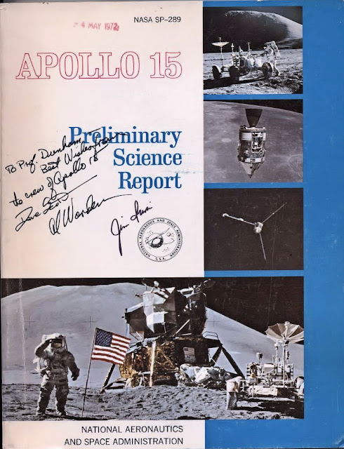
Inscribed copy of Apollo 15 Preliminary Science Report

Inscribed cover of Apollo 15 Preliminary Science Report
BGS image ID: P858063
The inscription on this copy of the Apollo 15 Preliminary Science Report reads "To Prof. Dunham. Best wishes from the crew of Apollo 15" followed by the signatures of the three crew members Dave Scott, Al Worden and Jim Irwin.

The Professor Dunham referred to is Kingsley Charles Dunham (1910-2001) who was the Professor of Geology at the University of Durham, 1950-1967 and Director of the Institute of Geological Sciences (now the British Geological Survey), 1967-1975.

Apollo 15 was launched on 26 July 1971, landed on the Moon on 30 July and splashed down back on Earth on 7 August. (Information from NASA mission pages). The report can be viewed here.

The British Geological Survey uses remote sensing techniques to study planetary geoscience. More can be read about that here.

Andrew L Morrison

Monday, 9 September 2013

Ben Peach field notebook sketch

 Landscape sketch by Ben Peach, Victorian geologist.
BGS image: P612917

 Landscape sketch by Ben Peach, Victorian geologist. 

Can anyone say where in Scotland this is?

Full two page picture:


Bob McIntosh

Monday, 2 September 2013

Quarrying Caithness Flagstones, Stonegunn Quarry, c. 1910

Stonegunn Quarry, 4.8 km. south-east of Thurso. Caithness. Method of levering the flagstones. The horizontal bed of rock is first split using chisels hammered in with a sledgehammer. It is then levered off the bedding plane with a crowbar. A quarryman in dress of the time (c.1910) is clearly seen. The rock is Devonian (Old Red Sandstone) Caithness Flagstones. After splitting each flag is taken away by means of crane and is subjected to preliminary squaring.
BGS Image ID: P000022
Stonegunn Quarry, 4.8 km. south-east of Thurso. Caithness. Method of levering the flagstones. The horizontal bed of rock is first split using chisels hammered in with a sledgehammer. It is then levered off the bedding plane with a crowbar. A quarryman in dress of the time (c.1910) is clearly seen. The rock is Devonian (Old Red Sandstone) Caithness Flagstones. After splitting each flag is taken away by means of crane and is subjected to preliminary squaring.

Bob McIntosh