Showing posts with label Scotland. Show all posts

Friday, 17 July 2015

Oblique aerial view of Craigielaw Point, Aberlady. East Lothian

Oblique aerial view of Craigielaw Point, Aberlady. East Lothian. Looking north-west. Bedded sediments. Lower Limestone Group. The Lower Limestone Group is the uppermost division of the Lower Carboniferous in the district. The strata has a regional dip to the west or north-west of up to 5 degrees, though between Craigielaw Point and Aberlady Point gentle minor folds are superimposed on the larger structure. Note the concrete anti-landing defences from World War 2.
BGS Image ID: P000795

Oblique aerial view of Craigielaw Point, Aberlady. East Lothian. Looking north-west. Bedded sediments. Lower Limestone Group. The Lower Limestone Group is the uppermost division of the Lower Carboniferous in the district. The strata has a regional dip to the west or north-west of up to 5 degrees, though between Craigielaw Point and Aberlady Point gentle minor folds are superimposed on the larger structure. Note the concrete anti-landing defences from World War 2.

Posted by Bob McIntosh

Sunday, 1 June 2014

Groundwater drilling in Scotland

Hardthorn Road site, Dumfries, Dumfries and Galloway Region. Water strike during drilling for groundwater at Hardthorn Road.   The rotary drilling rig encountered only dry Permian breccia to 56 m. depth. At this level, a water-bearing fissure suddenly produced a surge of water at the surface. Other fissures were encountered at intervals to 130 m. depth. The final yield of water from the borehole was over 35 litres per second. The borehole is to be used by West of Scotland Water as part of the Dumfries public supply system. The Silurian hills can be seen in the background. These encircle the Permian aquifer in the floor of the basin.
BGS Image ID: P001426
Hardthorn Road site, Dumfries, Dumfries and Galloway Region. Water strike during drilling for groundwater at Hardthorn Road. 

The rotary drilling rig encountered only dry Permian breccia to 56 m. depth. At this level, a water-bearing fissure suddenly produced a surge of water at the surface. Other fissures were encountered at intervals to 130 m. depth. The final yield of water from the borehole was over 35 litres per second. The borehole is to be used by West of Scotland Water as part of the Dumfries public supply system. The Silurian hills can be seen in the background. These encircle the Permian aquifer in the floor of the basin.

Adjacent to the A70 road near Tarbrax, Strathclyde Region. A V-notch tank in use during a pumping test on an exploratory groundwater borehole.   The borehole was drilled by West of Scotland Water as an exercise to see whether groundwater could be used to supply the village of Tarbrax, and replace an unreliable surface stream source. The borehole, drilled into Upper Devonian sandstone and mudstone, yielded over 7 litres/second. The V-notch tank is used to measure the water flow, by comparing the height of water flowing over the V with flow rates in a reference table. The drill rig in the background was used to drill the borehole and install the electric pump to 50 m. depth.
BGS Image ID: P001434
 Adjacent to the A70 road near Tarbrax, Strathclyde Region. A V-notch tank in use during a pumping test on an exploratory groundwater borehole. 

The borehole was drilled by West of Scotland Water as an exercise to see whether groundwater could be used to supply the village of Tarbrax, and replace an unreliable surface stream source. The borehole, drilled into Upper Devonian sandstone and mudstone, yielded over 7 litres/second. The V-notch tank is used to measure the water flow, by comparing the height of water flowing over the V with flow rates in a reference table. The drill rig in the background was used to drill the borehole and install the electric pump to 50 m. depth.

Bridge Farm borehole, Machrie, Arran. An artesian, flowing, borehole drilled into the Permian sandstone aquifer at Machrie, Arran. A T.V. log of the borehole is being undertaken, using a BGS Land Rover.  The flow of water was measured at 10 litres/second, which makes it one of the highest naturally-flowing boreholes in Scotland. Most of the water is coming into the borehole at depths between 65 m. and 95 m. below ground level. The quality of the water is very high, and it is hoped that West of Scotland Water will use this source for most of the island's water supply before 2002.
BGS Image ID: P001440
Bridge Farm borehole, Machrie, Arran. An artesian, flowing, borehole drilled into the Permian sandstone aquifer at Machrie, Arran. A T.V. log of the borehole is being undertaken, using a BGS Land Rover.

The flow of water was measured at 10 litres/second, which makes it one of the highest naturally-flowing boreholes in Scotland. Most of the water is coming into the borehole at depths between 65 m. and 95 m. below ground level. The quality of the water is very high, and it is hoped that West of Scotland Water will use this source for most of the island's water supply before 2002.

Bridge Farm borehole, Machrie, Arran. Drilling a groundwater production borehole for West of Scotland Water at Machrie, Arran.  The drill rig is located close to the 'String' road from Brodick at a site chosen by the Hydrogeology Group of BGS. The rig is using an air flush hammer to drill through Permian sandstone. The compressor is seen at the left. Compressed air is sent down the drill rods to the hammer at the bottom of the borehole. The air operates the hammer and brings cuttings and water to the surface. The water flows away from the site to a stream. The 4-wheel drive tractor unit powers the rig and is highly manoeuvrable - useful for sites with problematical access.
BGS Image ID: P001441
Bridge Farm borehole, Machrie, Arran. Drilling a groundwater production borehole for West of Scotland Water at Machrie, Arran.

The drill rig is located close to the 'String' road from Brodick at a site chosen by the Hydrogeology Group of BGS. The rig is using an air flush hammer to drill through Permian sandstone. The compressor is seen at the left. Compressed air is sent down the drill rods to the hammer at the bottom of the borehole. The air operates the hammer and brings cuttings and water to the surface. The water flows away from the site to a stream. The 4-wheel drive tractor unit powers the rig and is highly maneuverable - useful for sites with problematical access.

Photographs by Derek Ball

Posted: Bob McIntosh

Sunday, 11 May 2014

Standing stones and burial chambers, geoarchaeology

Standing Stones of Stenness, south-east end of Loch of Stenness. Orkney. The henge and stone circle have radiocarbon dates suggesting that Stenness was constructed during the 3rd. millennium B.C. Four thin, unshaped flagstones now survive, the tallest over five metres high; it is thought that there were originally twelve stones set in a circle about 30 metres in diameter. Ploughing has almost levelled the henge earthworks but the circle once stood within a ditch and bank, with an entrance causeway to the north. The henge and stone circle of Stenness together with the Ring of Brodgar and associated outlying stones and burial mounds form part of a great ceremonial complex in the heart of Orkney, comparable to Callanish on Lewis in the Western Isles and to Stonehenge on Salisbury Plain in Wiltshire.
BGS Image ID: P000605
Standing Stones of Stenness, south-east end of Loch of Stenness. Orkney. The henge and stone circle have radiocarbon dates suggesting that Stenness was constructed during the 3rd. millennium B.C. Four thin, unshaped flagstones now survive, the tallest over five metres high; it is thought that there were originally twelve stones set in a circle about 30 metres in diameter. Ploughing has almost levelled the henge earthworks but the circle once stood within a ditch and bank, with an entrance causeway to the north. The henge and stone circle of Stenness together with the Ring of Brodgar and associated outlying stones and burial mounds form part of a great ceremonial complex in the heart of Orkney, comparable to Callanish on Lewis in the Western Isles and to Stonehenge on Salisbury Plain in Wiltshire.

Dwarfie Stane, north-west Hoy, Orkney. The Dwarfie Stane is a neolithic burial chamber hollowed out from a solid block of cross-bedded Hoy Sandstone (Upper Old Red Sandstone). It is thought that the Dwarfie Stane is derived from cliffs on the downthrow side of the Bring Fault where massive beds of yellow or more rarely red sandstones of the Hoy Sandstone are found (the escarpment in the background).
BGS Image ID: P000597
Dwarfie Stane, north-west Hoy, Orkney. The Dwarfie Stane is a neolithic burial chamber hollowed out from a solid block of cross-bedded Hoy Sandstone (Upper Old Red Sandstone). It is thought that the Dwarfie Stane is derived from cliffs on the downthrow side of the Bring Fault where massive beds of yellow or more rarely red sandstones of the Hoy Sandstone are found (the escarpment in the background).

Avebury stone circles, Wiltshire. Avebury is the largest 'henge' or stone circle in Britain.The standing stones of the Avebury circles, which range from 0.5 m. to 6 m. in height and number over 150 in total, are pale grey, silica-cemented sandstones of Tertiary age commonly known as sarsen stones. The source of the sarsen stone used in the megalithic site at Avebury is believed to be the Marlborough Downs. The stones were formed by the cementation of loose sands in the remnants of the Tertiary succession that once covered the downs. Some of the stones were revealed by weathering but others were probably dug from the succession and transported to Avebury. Sarsen stones are widely used in southern Britain at prehistoric sites including Avebury, Long Kennet and Stonehenge. Although best known as standing stones the sandstones were once extensively quarried on the Marlborough Downs for building stone. However, many standing stones are also believed to have been removed from the prehistoric structures for building purposes in earlier times.
BGS Image ID: P211066
Avebury stone circles, Wiltshire. Avebury is the largest 'henge' or stone circle in Britain.The standing stones of the Avebury circles, which range from 0.5 m. to 6 m. in height and number over 150 in total, are pale grey, silica-cemented sandstones of Tertiary age commonly known as sarsen stones. The source of the sarsen stone used in the megalithic site at Avebury is believed to be the Marlborough Downs. The stones were formed by the cementation of loose sands in the remnants of the Tertiary succession that once covered the downs. Some of the stones were revealed by weathering but others were probably dug from the succession and transported to Avebury. Sarsen stones are widely used in southern Britain at prehistoric sites including Avebury, Long Kennet and Stonehenge. Although best known as standing stones the sandstones were once extensively quarried on the Marlborough Downs for building stone. However, many standing stones are also believed to have been removed from the prehistoric structures for building purposes in earlier times.

Wayland's Smithy long barrow, Berkshire. Looking north. The Chalk downland area known as the Ridgeway, forming the southern edge of the Vale of the White Horse, is one of several areas littered with sarsen sandstone blocks. The sandstones are the remnants of a former Tertiary sedimentary cover and in some areas may be very abundant as at Clatford Bottom. Wayland's Smithy, named after the Saxon god of metalworking, is a neolithic long barrow constructed of silica-cemented, sandstone blocks known as sarsen stones or sometimes greywethers.
BGS Image ID: P211066
Wayland's Smithy long barrow, Berkshire. Looking north. The Chalk downland area known as the Ridgeway, forming the southern edge of the Vale of the White Horse, is one of several areas littered with sarsen sandstone blocks. The sandstones are the remnants of a former Tertiary sedimentary cover and in some areas may be very abundant as at Clatford Bottom. Wayland's Smithy, named after the Saxon god of metalworking, is a neolithic long barrow constructed of silica-cemented, sandstone blocks known as sarsen stones or sometimes greywethers. 

See also Stonehenge on BGS Geoheritage

Posted by Bob McIntosh
Sunday, 24 November 2013

Three Scottish building stone specimens

Rock specimen of sandstone from Bloody Mires Quarry, Kippen Muir, Central Region, Scotland.  Sample of red sandstone, showing uniform grainsize and colour. This specimen is of Devonian age. British Geological Survey Petrology Collection sample number MC2092. This sample is from an abandoned quarry which may have been used for local building stone. Red sandstone was commonly used in Scotland from the late 19th century. The largest and most significant quarries of red sandstone in Scotland were in Ayrshire and Dumfriesshire, from where the stone was transported by railway.
BGS Image ID: P519461
Rock specimen of sandstone from Bloody Mires Quarry, Kippen Muir, Central Region, Scotland.

Sample of red sandstone, showing uniform grainsize and colour. This specimen is of Devonian age. British Geological Survey Petrology Collection sample number MC2092. This sample is from an abandoned quarry which may have been used for local building stone. Red sandstone was commonly used in Scotland from the late 19th century. The largest and most significant quarries of red sandstone in Scotland were in Ayrshire and Dumfriesshire, from where the stone was transported by railway.


Rock specimen of sandstone from Hailes Quarry, Edinburgh, Lothian Region, Scotland.   Oblique photograph of a specimen of Hailes sandstone, with the name of the quarry carved on one side. This specimen is of Carboniferous age. British Geological Survey Petrology Collection sample number MC1318. The upper surface has been left in its natural state, showing the uneven bedding surface. Such samples were prepared by the quarry in order to market the stone. This sample dates from before the First World War. Size of specimen: 11x11x5 cm. Munsell colour code and colour 5YR8/1, pinkish grey.
BGS Image ID: P519533
Rock specimen of sandstone from Hailes Quarry, Edinburgh, Lothian Region, Scotland.

Oblique photograph of a specimen of Hailes sandstone, with the name of the quarry carved on one side. This specimen is of Carboniferous age. British Geological Survey Petrology Collection sample number MC1318. The upper surface has been left in its natural state, showing the uneven bedding surface. Such samples were prepared by the quarry in order to market the stone. This sample dates from before the First World War. Size of specimen: 11x11x5 cm. Munsell colour code and colour 5YR8/1, pinkish grey.


Specimen of roofing slate quarried from Easdale Island, Argyllshire, Scotland This slate shows the trade mark stamp of the Easdale Slate Company. The specimen is of Precambrian, Dalradian age. British Geological Survey Petrology Collection sample number EMC 5736. The slate is a typical dark grey colour with a strong 'grain' and containing pyrite crystals. This specimen was donated to the Geological Survey of Scotland sometime before 1916. For hundreds of years slate was the preferred roofing material in Scotland. The geological variation found in slate quarries from across Scotland meant that each produced a characteristic slate, with a colour, texture and thickness varying from region to region.
BGS Image ID: P519560
Specimen of roofing slate quarried from Easdale Island, Argyllshire, Scotland

This slate shows the trade mark stamp of the Easdale Slate Company. The specimen is of Precambrian, Dalradian age. British Geological Survey Petrology Collection sample number EMC 5736. The slate is a typical dark grey colour with a strong 'grain' and containing pyrite crystals. This specimen was donated to the Geological Survey of Scotland sometime before 1916. For hundreds of years slate was the preferred roofing material in Scotland. The geological variation found in slate quarries from across Scotland meant that each produced a characteristic slate, with a colour, texture and thickness varying from region to region.

Bob McIntosh

Sunday, 6 October 2013

Crushed samples of feldspar from Scotland

Crushed samples of feldspar from Scotland   Potash feldspar was first in demand for the production of fertilizers, later during the Second World War deposits of potash feldspar were investigated for the production of ceramic ware. British Geological Survey Petrology Collection sample number MC 7436. To extract the potash numerous methods have been devised. They include 1. Simple wet grinding and electrolysis, this proved unsuccessful and only one-third of the alkali present could be extracted by this method. 2. Treatment with chemical solutions, either caustic alkalis or acids. 3. Volatization of potash-salts, this involved heating feldspar with gypsum and carbon with potassium sulphate being volatilized and then recovered. 4. A number of dry processes for the separation of potash existed e.g. separation of potash as hydroxide or carbonate; as sodium or potassium chlorides; extraction of sodium and potassium sulphate.
BGS image ID:  P527656

Crushed samples of feldspar from Scotland 

Potash feldspar was first in demand for the production of fertilizers, later during the Second World War deposits of potash feldspar were investigated for the production of ceramic ware. British Geological Survey Petrology Collection sample number MC 7436. To extract the potash numerous methods have been devised. They include 1. Simple wet grinding and electrolysis, this proved unsuccessful and only one-third of the alkali present could be extracted by this method. 2. Treatment with chemical solutions, either caustic alkalis or acids. 3. Volatization of potash-salts, this involved heating feldspar with gypsum and carbon with potassium sulphate being volatilized and then recovered. 4. A number of dry processes for the separation of potash existed e.g. separation of potash as hydroxide or carbonate; as sodium or potassium chlorides; extraction of sodium and potassium sulphate.

Bob McIntosh

Monday, 9 September 2013

Ben Peach field notebook sketch

 Landscape sketch by Ben Peach, Victorian geologist.
BGS image: P612917

 Landscape sketch by Ben Peach, Victorian geologist. 

Can anyone say where in Scotland this is?

Full two page picture:


Bob McIntosh

Monday, 10 June 2013

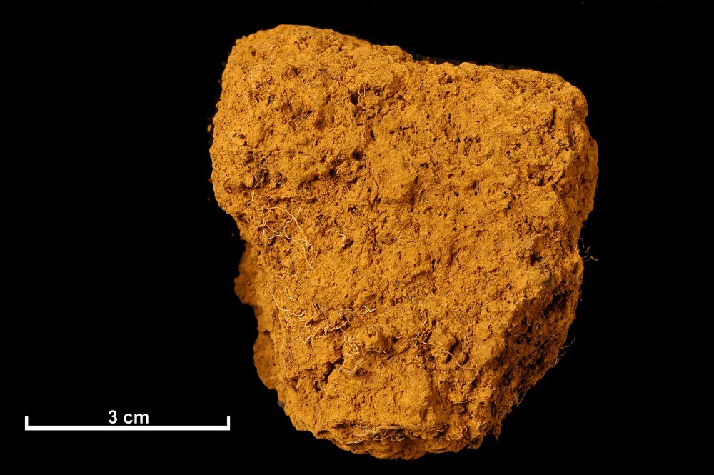
Bog iron ore from Scotland

Bog iron ore from Lon Odhar, South Erradale, Gairloch, Ross and Cromarty.  The South Erradale bog iron ore is a good example of ore from the comparatively small pans that occur in the Loch Maree area were associated with the long history of bloomeries and furnaces in the area. British Geological Survey Petrology Collection sample number MC 7359. An early analysis by Ivison Macadam of two samples of South Erradale bog iron ore are sample a, 70.88 per cent ferric oxide; 49.61 per cent metallic iron; 7.48 per cent silica. Sample b, 66.68 per cent ferric oxide; 46.67 per cent metallic iron and 8.24 per cent silica. It is thought that the deposits were so small and few that the local bog iron ores would have been exhausted in early times and that iron would have been imported from elsewhere, possibly haematite from Cumberland and clayband ironstone from Fifeshire.
BGS image ID: P527579
Bog iron ore from Lon Odhar, South Erradale, Gairloch, Ross and Cromarty.

The South Erradale bog iron ore is a good example of ore from the comparatively small pans that occur in the Loch Maree area associated with the long history of bloomeries and furnaces in the area. British Geological Survey Petrology Collection sample number MC 7359. An early analysis by Ivison Macadam of two samples of South Erradale bog iron ore are sample a, 70.88 per cent ferric oxide; 49.61 per cent metallic iron; 7.48 per cent silica. Sample b, 66.68 per cent ferric oxide; 46.67 per cent metallic iron and 8.24 per cent silica. It is thought that the deposits were so small and few that the local bog iron ores would have been exhausted in early times and that iron would have been imported from elsewhere, possibly haematite from Cumberland and clayband ironstone from Fifeshire.


Bog iron ore from an iron pan on the west shore of Kirst Shun, one quarter of a mile north-north-east of Clothister Hill, Shetland.  Bog iron ore from an iron pan on the west shore of Kirst Shun, one quarter of a mile north-north-east of Clothister Hill, Shetland. It is recorded that in 1874 Shetland produced 692 tons of bog iron ore. British Geological Survey Petrology Collection sample number MC 7361. Evidence for the earliest traces of iron-making in Scotland can be seen in the bloomeries where local bog iron ore of recent origin was smelted. They arose in several areas due to the availability of bog iron ore and a good supply of timber for charcoal making. Bog iron ore is a general term for soft, spongy and porous sedimentary deposits of impure hydrous iron oxides formed in bogs, swamps, marshes, peat mosses and shallow lakes from the chemical precipitation from iron-bearing waters and by the oxidizing action of algae, iron bacteria or the atmosphere.
BGS image ID: P527581
Bog iron ore from an iron pan on the west shore of Kirst Shun, one quarter of a mile north-north-east of Clothister Hill, Shetland. 

It is recorded that in 1874 Shetland produced 692 tons of bog iron ore. British Geological Survey Petrology Collection sample number MC 7361. Evidence for the earliest traces of iron-making in Scotland can be seen in the bloomeries where local bog iron ore of recent origin was smelted. They arose in several areas due to the availability of bog iron ore and a good supply of timber for charcoal making. Bog iron ore is a general term for soft, spongy and porous sedimentary deposits of impure hydrous iron oxides formed in bogs, swamps, marshes, peat mosses and shallow lakes from the chemical precipitation from iron-bearing waters and by the oxidizing action of algae, iron bacteria or the atmosphere.

Thursday, 18 April 2013

Iron ore from a vein at the east end of Loch Monar, Ross and Cromarty


A collection of specimens of iron ore from a vein at the east end of Loch Monar, Ross and Cromarty, showing a distinctive botryoidal form.
BGS image ID: P527598
A collection of specimens of iron ore from a vein at the east end of Loch Monar, Ross and Cromarty, showing a distinctive botryoidal form. Iron making has had a long history in Scotland. Firstly bog iron ores were used in the early bloomeries and later, haematite and clayband ironstones were used, the former probably imported. Iron ores such as this specimen were fairly rare in Scotland, perhaps the most well known locality is the Leicht Mine at Tomintoul. Iron ores come in many types from bog iron ores, haematite ores, clayband and blackband Carboniferous ores and the much younger Jurassic ores such as those from Raasay.

British Geological Survey Petrology Collection sample number MC 7378. 

Bob McIntosh

Wednesday, 13 March 2013

The Bandits' Lair - the 'Desperadoes' of the Geological Survey of Scotland, 1885


The names of those desperadoes are (left to right), back row - J.B. Hill, L.W. Hinxman, J. Horne, G. Barrow. Front row (left to right), J. Linn, B.N. Peach, H. Miller, W. Gunn.
BGS image ID: P008715
The Bandits' Lair. The names of those desperadoes are (left to right), back row - J.B. Hill, L.W. Hinxman, J. Horne, G. Barrow. Front row (left to right), J. Linn, B.N. Peach, H. Miller, W. Gunn. 

The 'Bandits' Lair' almost certainly dates from 1885, probably in the Spring of that year. Geikie instructed the newly recruited members of the Scottish staff that had been mapping in northern England previously to attend a 2-3 day trip/workshop in the NW Highlands with Peach and Horne. This is recorded in the Summary of Progress for 1885 and confirmed by Barrow notes on a later manuscript. Barrow, Clough, Dakyns, Gunn and Miller moved to the Scottish Office in 1884. Hinxman and Cadell were recruited in 1883. The photo was probably taken in Sutherland as they visited Loch Eriboll and the Scourie area. The two people missing are Dakyns and Cadell. It is suspected that Cadell was the photographer. The photo cannot be later as there is no recorded instance of the same body of people being in the field together subsequently. Also Linn became ill soon after and did little field work. [Text, John Mendum]

Bob McIntosh