Thursday, 19 February 2015

Sir Roderick Impey Murchison at the Museum of Practical Geology

Photograph. Written on the back of the photograph is ' Sir Roderick Murchison (restoration)'.
 BGS Image ID: P640912

Written on the back of the photograph is ' Sir Roderick Murchison (restoration)'.

It would be interesting to find out the story behind the mannequin - who was the wag who perpetrated this?

Museum of Practical Geology, Jermyn Street, London. c1855 -1900 GSM/MG/E/5.

Posted by Bob McIntosh

Wednesday, 28 January 2015

Photograph from the Frederic William Harmer collection. Above Runton Gap

Above Runton Gap, 3rd October 1907.  Two names noted Gottsche and Tietze. Photograph from the Frederic William Harmer collection.
BGS Image ID: P680269

Above Runton Gap, Norfolk, 3rd October 1907.  Two names noted Gottsche and Tietze. Photograph from the Frederic William Harmer collection.

Runton is the main outcrop of the type deposit of the Cromerian warm stage  the West Runton Freshwater Bed. The latter is highly fossiliferous containing remains of plants and trees, molluscs, fish, amphibians, large and small mammals and birds.

Probably Carl Christian Gottsche and Emil Ernst August Tietze, can anyone confirm?

Posted by Bob McIntosh

Wednesday, 7 January 2015

E.O. Teale collection - transport in East Africa

Wilson Airways aeroplane, E.O. Teale photograph collection

Travel in East Africa in the 1920s. By air, boat and motor car!
(a De Haviland Dragon  ID courtesy of Richard Holowka @RichHolowka)
Travel by boat, East Africa, 1920s

Travel by boat, East Africa
Travel by car East Africa 1920s. E.O. Teale Collection

Travel by car East Africa 1920s. E.O. Teale Collection

Travel by car East Africa 1920s. E.O. Teale Collection

Travel by car East Africa 1920s. 

The full E. O. Teale photograph collection can be found on Geoscenic

Posted by Bob McIntosh

Friday, 5 December 2014

On the manufacture of gun-flints, Memoir of the Geological Survey 1879.

Title page of: Memoir Geological Survey. England and Wales. On the manufacture of gun-flints, the method of excavating for flint, the age of Palaeolithic Man and the connexion between Neolithic art and the gun-flint trade by Sydney B.J. Skertchly. London : HMSO, 1879.

Title page of: Memoir Geological Survey. England and Wales. On the manufacture of gun-flints, the method of excavating for flint, the age of Palaeolithic Man and the connexion between Neolithic art and the gun-flint trade by Sydney B.J. Skertchly. London : HMSO, 1879. The memoir is an exhaustive account of the making of gun-flints at Brandon in Sussex.

The memoir is a regarded as a classic by modern day flint knappers.


Sample page showing a few of the wide range of gun-flints that were available at the time - all with interesting names such as Mixed Grey or Spotted Horse Pistol, Chalk-heeled Horse Pistol, Best Carbine, Solid Grey Musket etc.

Sample page showing descriptions of the thirty-three gun-flints that were available at the time. The gun-flints had interesting names such as Mixed Grey or Spotted Horse Pistol, Chalk-heeled Horse Pistol, Best Carbine, Solid Grey Musket etc. They were all made by eye, no measurements were involved.

Illustration showing knappers at work.

Illustration showing knappers at work. Flint was mined from chalk pits, each pit lasting from six to nine months. The miners sold the flints to the flint knappers by the 'jag' which is one cart-load about equal to a ton. 

To manufacture the gun-flints there were four processes:

Drying - flint would be dried outside in the summer but in the winter it was dryed around the fire indoors.

Quartering - a block of stone is taken and quartered - they may weigh a quarter of a hundredweight to two hundredweights.

Flaking - The most difficult process and requires great skill and 'nicety of judgement'.

Knapping - The final process of forming the flakes into gun-flints. A good flake will make four, and a very good one five flints. An average workman will knap 3,000 flints in a day of 12 hours. One man working from 4 a.m. until 11 p.m. made 24,000 in a week!

Illustration showing how a flint fractures to provide a series of flakes. Just one stage in the process of making gun-flints.

Illustration showing how a flint fractures to provide a series of flakes. Just one stage in the process of making gun-flints.

Watch a video on flint mining and knapping at Brandon in the 1930s and 1940s here  and here. Definitely worth watching!

Posted by Bob McIntosh

Friday, 14 November 2014

Flints from Piltdown, Sussex

These flints were found in a gravel pit at Piltdown in Sussex by Charles Dawson (1864-1916), a local solicitor and amateur archaeologist. The gravel pit was the same one in which the now infamous Piltdown Man was discovered. It is widely believed that Dawson was responsible for this audacious fraud.

Large flint from gravel bed, Piltdown, Sussex
BGS image ID: P903735

Glazed flints from Piltdown gravel, Sussex
BGS image ID: P903736

Large flint from Piltdown gravel, Sussex
BGS Image ID: P903738

BGS has a Piltdown Forgery webpage and timeline which can be accessed here

Andrew L Morrison

Monday, 3 November 2014

Penmaenmawr Mountain Top Quarry

Penmaenmawr Mountain Top Quarry. Conveyors down to loading pier.
BGS Image ID: P539567

Penmaenmawr Mountain Top Quarry. Conveyors down to loading pier.

Penmaenmawr Mountain Top Quarry. Ship loading jetty - some of output went by boat to London.
BGS Image ID: P539617

Ship loading jetty - some of output went by boat to London.

Penmaenmawr Mountain Top Quarry. Drilling shot holes
BGS Image ID: P539574

Drilling shot holes.

Images from the Hugh O'Neill collection. Photographs taken c 1960-61.

Posted by: Bob McIntosh

Monday, 20 October 2014

English churches - building stones


Drewsteignton village square, Devon. Looking east. Drewsteignton village is sited high on the northern edge of Dartmoor. Holy Trinity Church and Church House with its large chimney stack are both built of Dartmoor granite blocks. Drewsteignton village is typical of many on the the northern fringe of Dartmoor. The church tower is built of Dartmoor granite (imported to the district). The house to the right of the lych gate is built largely of rough hewn granite blocks. The wall to the left of the lych gate is built of blocks of impure limestone and hornfelsed mudstone from the local quarries (now disused). The granites of Devon and Cornwall and their associated intrusive and metamorphic rocks have commonly been worked in the past for building stone, both for local housing and for major building projects elswhere in the United Kingdom such as the many 19th century dock construction schemes in London.
BGS Image ID: P209976
Drewsteignton village square, Devon. Looking east. Drewsteignton village is sited high on the northern edge of Dartmoor. Holy Trinity Church and Church House with its large chimney stack are both built of Dartmoor granite blocks. Drewsteignton village is typical of many on the the northern fringe of Dartmoor. The church tower is built of Dartmoor granite (imported to the district). The house to the right of the lych gate is built largely of rough hewn granite blocks. The wall to the left of the lych gate is built of blocks of impure limestone and hornfelsed mudstone from the local quarries (now disused). The granites of Devon and Cornwall and their associated intrusive and metamorphic rocks have commonly been worked in the past for building stone, both for local housing and for major building projects elswhere in the United Kingdom such as the many 19th century dock construction schemes in London.

Snettisham Church, Norfolk. Looking east. This large, late medieval church at Snettisham is typical of many in this area where a mixture of local building stones are used for the main walling material, chalk, flints and ferruginous carstone, with better quality oolitic freestones of the Lincolnshire Limestone Formation imported for more ornate mouldings and carved stonework. Built in the 14th century decorated style, Snettisham Church has its nave and tower constructed of partially dressed blocks of chalk and flint. The spire, pinnacles, copings, buttresses and window tracery are made of oolitic limestone, one of the Middle Jurassic freestones. The wall in the foreground is made of dressed Carstone blocks which have suffered some frost damage. While this area of Norfolk produced a wide variety of local building materials, including sandstones, limestones and flints, none were good enough to qualify as freestones. Consequently from medieval times onwards the oolitic limestones of Lincolnshire were commonly imported for the stonework in all the more prestigious buildings.
BGS Image ID: P210728
Snettisham Church, Norfolk. Looking east. This large, late medieval church at Snettisham is typical of many in this area where a mixture of local building stones are used for the main walling material, chalk, flints and ferruginous carstone, with better quality oolitic freestones of the Lincolnshire Limestone Formation imported for more ornate mouldings and carved stonework. Built in the 14th century decorated style, Snettisham Church has its nave and tower constructed of partially dressed blocks of chalk and flint. The spire, pinnacles, copings, buttresses and window tracery are made of oolitic limestone, one of the Middle Jurassic freestones. The wall in the foreground is made of dressed Carstone blocks which have suffered some frost damage. While this area of Norfolk produced a wide variety of local building materials, including sandstones, limestones and flints, none were good enough to qualify as freestones. Consequently from medieval times onwards the oolitic limestones of Lincolnshire were commonly imported for the stonework in all the more prestigious buildings.


St Mary's Church, Purton, Wiltshire. Looking north-west. This Norman / Medieval church with its spire and crossing tower is constructed of Jurassic Coral Rag limestones. The term Rag refers to the coarse grained shelly (or ragged nature) of the limestone when fractured. The ragstone beds are generally very hard and durable stones but are consequently, therefore, very difficult to work, commonly they are used as undressed rubblestone blocks. This church at Purton is largely built of local 'Coral Rag' Limestone from the local Osmington Oolite Formation.The roof of the church is covered with stone slates which in this area are likely to be from the Forest Marble Formation, although some use of local Purbeck limestones is also known. The hard, pale grey, coarsely oolitic and shelly limestones of the Corallian Group were widely used in buildings along their outcrops in Dorset, Wiltshire and Oxfordshire.
BGS Image ID: P210855
St Mary's Church, Purton, Wiltshire. Looking north-west. This Norman / Medieval church with its spire and crossing tower is constructed of Jurassic Coral Rag limestones. The term Rag refers to the coarse grained shelly (or ragged nature) of the limestone when fractured. The ragstone beds are generally very hard and durable stones but are consequently, therefore, very difficult to work, commonly they are used as undressed rubblestone blocks. This church at Purton is largely built of local 'Coral Rag' Limestone from the local Osmington Oolite Formation.The roof of the church is covered with stone slates which in this area are likely to be from the Forest Marble Formation, although some use of local Purbeck limestones is also known. The hard, pale grey, coarsely oolitic and shelly limestones of the Corallian Group were widely used in buildings along their outcrops in Dorset, Wiltshire and Oxfordshire.

Posted by Bob McIntosh

Tuesday, 7 October 2014

BGS maps portal — maps and sections 1832 to 2014

Sheet 10 [Isle of Wight, Lyrnington, part of Portsmouth Harbour.] Geological Survey of England and Wales Old Series. 1:63,360. 1856.
Sheet 10 [Isle of Wight, Lyrnington, part of Portsmouth Harbour.] Geological Survey of England and Wales Old Series. 1:63,360. 1856.
Two sheets separated by 157 years. Both available as high resolution scans on the new BGS Maps Portal  

Isle of Wight special sheet. Geological Survey of England and Wales 1:50,000 map. 2013

The British Geological Survey (BGS) has  released high resolution scans of over 6000 geological maps which were previously published on paper. The “BGS Maps Portal” provides free to view small and medium scale maps produced by the BGS since geological mapping began in 1832. The Maps Portal includes the recent 1:50,000 mapping of England, Wales and Scotland, geochemical and geophysical maps and also the historical maps that were in the former BGS historical maps website. 

Posted by Bob McIntosh

Thursday, 18 September 2014

Franklin's Ships: Records from HMS Erebus and HMS Terror

‘Term day books’ from HMS Erebus and HMS Terror, 1840-1842, containing both magnetic and meteorological observations

‘Term day books’ from HMS Erebus and HMS Terror, 1840-1842, containing both magnetic and meteorological observations.


Sir John Franklin’s fabled lost expedition, back in the news last week after one of the ships was found by Canadian search vessels, was not the first time that the two ships HMS Erebus and HMS Terror set sail together on a voyage of exploration. Six years before Erebus and Terror departed England for the Arctic, they were beginning a four year expedition that would take them southwards to the Antarctic. On that journey they were led by Captain James Clark Ross, an experienced polar explorer, with the second in command (and commander of HMS Terror) being Francis Crozier. Crozier was captain of the same ship on Franklin’s expedition, and is reported to have taken charge after Franklin’s death, with some suggestions that he survived for several years afterwards. 

One of the aims of both Ross’s Antarctic expedition and Franklin’s Arctic one was to collect magnetic data, and the data relating to the Antarctic can still be found in BGS’s collections today. Both HMS Erebus and HMS Terror recorded information relating to the earth’s magnetic field, as well as making meteorological observations such as details of aurora sightings. BGS holds similar records of many other Royal Navy ships, with data collected around the world throughout the nineteenth and early twentieth centuries. A list of Royal Navy ships’ geomagnetic log books held by BGS can be found here. Records of Ross’s expedition also live on in the names of many Antarctic landmarks – for example the Ross Ice Shelf, Ross Sea, and Ross Island with its two volcanoes Mount Erebus and Mount Terror.

See below for more images of records from HMS Erebus and HMS Terror.


Term day book and other papers containing magnetic and meteorological observations from HMS Erebus, 1840-1843. James Ross’s signature can be seen in the centre.

Term day book and other papers containing magnetic and meteorological observations from HMS Erebus, 1840-1843. James Ross’s signature can be seen in the centre.


Magnetic observations taken at Auckland Island (to the south of New Zealand), 5th December 1840, and Van Diemen’s Land (now Tasmania), May 1841, from HMS Erebus

Magnetic observations taken at Auckland Island (to the south of New Zealand), 5th December 1840, and Van Diemen’s Land (now Tasmania), May 1841, from HMS Erebus.

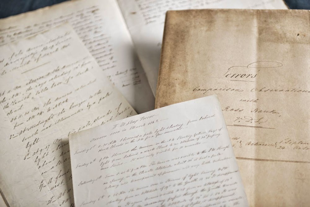
Papers from HMS Terror, 1841-1842. The document on the right compares magnetic observations from HMS Terror with those made at Ross Bank, Tasmania.

Papers from HMS Terror, 1841-1842. The document on the right compares magnetic observations from HMS Terror with those made at Ross Bank, Tasmania. 


Francis Crozier’s signature on a document recording auroras seen from HMS Terror in March 1842

Francis Crozier’s signature on a document recording auroras seen from HMS Terror in March 1842.

Monday, 8 September 2014

Forth Road Bridge construction. 50th Anniversary

A main lift. Images from the Hugh O'Neill collection of the construction of the Forth Road Bridge.
BGS image ID: P537923
A main lift. Images from the Hugh O'Neill collection of the construction of the Forth Road Bridge.

South Pier. Images from the Hugh O'Neill collection of the construction of the Forth Road Bridge.
BGS image ID: P537924
South pier.

Tensioning cables. Forth Road Bridge construction.
BGS image ID:  P537894
Tensioning cables.

Institute of Quarrying visit.  Forth Road Bridge construction.
BGS image ID: P537898
Institute of Quarrying visit

Tension cables. Forth Road Bridge construction.
BGS image ID: P537895
Tension cables.


Posted by Bob McIntosh