Friday, 16 November 2018

Edward Battersby Bailey (1881-1965)

E B Bailey doing fieldwork (P225785)
E B Bailey was born on 1 July 1881 at Marden, Kent. In 1902 he graduated with first-class honours in geology and physics from Clare College, Cambridge. In the same year he joined the Geological Survey of Great Britain and worked in Scotland.

In 1915 Bailey joined the Royal Garrison Artillery as a subaltern. He was wounded on the Somme in September 1916 and near Ypres in 1918. These wounds resulted in the loss of an eye and a permanently damaged left arm. Bailey was awarded the Military Cross, the Croix de Guerre and was made a Chevalier of the Légion d'honneur. In spite of his injuries he later wrote in Geological Survey of Great Britain (1952) "The 1914 War was a comparatively happy one for juniors on the staff..."

In 1919 Bailey became District Geologist for the West Highlands and Islands. He resigned from the Geological Survey in 1929 and took up the post of Professor of Geology at the University of Glasgow. In 1937 Bailey was appointed Director of the Geological Survey after the premature death of Bernard Smith.
Bailey in Russia, 1937 (P008691)

Bailey in the Home Guard, 1944
 (GSM/DR/Sb/7/5)
During the Second World War Bailey joined the Home Guard along with several other Survey staff. He recorded in Geological Survey of Great Britain that on one occasion "...I had been temporarily buried by a V1 or Doodlebug".

Bailey was Knighted in 1945 and in April of that year retired as Director of the Survey. He continued to be active in the field of geology until shortly before his death on 19 March 1965.
 
A G MacGregor in an obituary in the Geological Society of America Bulletin described Bailey as "a very great geological leader and investigator". Rather more irreverently he was described in Down to Earth: One Hundred and Fifty Years of the British Geological Survey (1985) as "perhaps the most eccentric Director of them all".

You can find out more about the Geological Survey and the First World War in the paper "Some aspects of the British Geological Survey’s contribution to the war effort at the Western Front, 1914–1918" by D G Bate and A L Morrison. This can be downloaded here

Andrew L Morrison

Thursday, 8 November 2018

Frederick Murray Trotter (1897-1968)


F M Trotter in 1927
Artist's impression of Trotter as a dispatch rider

F M Trotter was born at Gateshead on 19 April 1897. In 1916 he was studying geology and chemistry at Armstrong College, Newcastle when, at the age of 18, he joined the Royal Engineers. Trotter was sent to the Western Front as a dispatch Rider. In 1918 while near Vimy he was badly wounded by shrapnel and lost one of his eyes and part of his skull.

Sketch of Trotter c1937 (P832327)
After he recovered Trotter was able to resume his studies at Armstrong College and was awarded his BSc in 1920. In 1921 he joined the Geological Survey of Great Britain and was first stationed at their office at Whitehaven, Cumbria. A study of the glacial history of the Vale of Eden and surrounding areas gained him a DSc.

In 1933 Trotter moved to the Forest of Dean and at the outbreak of the Second World War he was sent to South Wales to work on the coalfield. At the end of 1941 he was promoted to District Geologist for the North-West of England and in 1955 he became Assistant Director (Deputy Chief Scientific Officer). He retired in 1963 and died on 24 July 1968.

In an obituary in the Proceedings of the Geologist's Association his former colleague William Colin Campbell Rose wrote: It was a constant source of wonder and admiration to his colleagues that despite this tremendous handicap  (of which he never complained) he enjoyed his life and work to the full and seemed not to suffer any disadvantage.

 You can find out more about the Geological Survey and the First World War in the paper "Some aspects of the British Geological Survey’s contribution to the war effort at the Western Front, 1914–1918" by D G Bate and A L Morrison. This can be downloaded here

Andrew L Morrison

Tuesday, 6 November 2018

Cecil Henry Cunnington (1889-1918)

Detail from one of Cunnington's field slips (Haunton, Staffordshire)
C H Cunnington (of whom we do not have a photograph) was born on 7 June 1889. In 1909 he obtained a first class honours degree in Geology from University College, London. Cunnington joined the Geological Survey of Great Britain in 1910 and spent much of the next four years surveying an area bordering the Warwickshire Coalfields. An obituary in the Proceedings of the Geological Society later referred to this as "excellent work".

He had joined the Officer's Training Corps before the outbreak of the First World War so entered the army soon after it began. In 1915 he was sent to Gallipoli on special military duty along with two other former staff from the Geological Survey, R W Pocock and T H Whitehead.

R W Pocock (P810105)
The work they did was related to trying to find an adequate water supply for the troops there. An unpublished report on the geology of the Gallipoli peninsula was produced for the War Office. Sadly, it is now untraceable. 

After returning from Gallipoli, Cunnington joined the Machine Gun Corps and served in France. He was invalided out of the army in 1917 and later underwent a major operation. He suffered a relapse and died on 26 April 1918. 

During the war 29 staff from the Geological Survey and Museum joined the armed forces. They consisted of 14 geologists, 3 fossil collectors, 2 general assistants, 3 attendants, 4 draughtsmen, 2 labourers and 1 assistant clerk. Cecil Cunnington holds the unfortunate distinction of being the only one of those who did not survive the war.

For a detailed study of the terrain at Gallipoli see Doyle, P & Bennett, M R 1999. "Military Geography: the influence of terrain in the outcome of the Gallipoli Campaign, 1915". Geographical Journal, 165, p12-35

You can find out more about the Geological Survey and the First World War in the paper "Some aspects of the British Geological Survey’s contribution to the war effort at the Western Front, 1914–1918" by D G Bate and A L Morrison. This can be downloaded here

Andrew L Morrison

Monday, 22 October 2018

H H Thomas, the Geological Survey and the First World War


H H Thomas (P585032)

In September 1916 the Geological Survey was contacted by the Admiralty Compass Department asking for assistance with the design of aircraft compasses. The problem was with the compass point and cup which were part of the bearing that allowed the compass needle to move. Herbert H Thomas, a petrographer at the Survey, was given the task of finding a solution. The point and cup were both made out of sapphire, which caused the point to develop flaws and cracks. In a report Thomas and Survey chemist E G Radley wrote:
Page of report by Thomas and Radley (GSM/DR/St/A/20)

“It appeared desirable that sapphire should be retained as the material for the cup, and therefore we sought some slightly less hard substance suitable for the points.
   Agate, from its closely felted microscopic structure, absence of cleavage and inclusions, moderate hardness and extreme toughness, was selected as the most suitable natural substance for the purpose. It is also cheap and can be obtained easily in this country in homogenous masses.”
This combination of sapphire and agate turned out to be successful and solved the problem.
H H Thomas was also involved in the analysis of concrete from German fortifications.
In September 1917 it was noticed that German concrete pill-boxes on Vimy Ridge, which had been captured by Canadian troops, were made with gravel which could not have come from Belgium. It was suspected that the Germans had transported the gravel through the neutral Netherlands. If this was the case then it was in contravention of the Netherland's neutrality declaration as the Dutch were supposed to prevent the belligerent powers from transporting military materials across neutral territory.
By October samples of the suspect concrete had been received by the Geological Survey and analysed. One of these samples was F2397.      

 Niedermendig lava set in concrete
(F2397)
Photomicrograph of Niedermendig lava (viewed under crossed polars)
(F2397) 

In a report Thomas described it as:
 "Fine grained grey spongy lava. Tephrite. Occurs as angular fragments and chips, and has the appearance of a quarried rock. This rock by its mineral-constitution and structure is of an unmistakable type. It has all the characters of the Niedermendig tephrite, so extensively quarried on the eastern slopes of the Eifel, bordering on the Rhine. Its usual port of Shipment is Andernach" 
Page from report by Thomas (BGS Archives: GSM/PT/A/27)

This meant that the gravel must have come from Germany. This issue was so important the J J H Teall, a former Director of the Geological Survey was brought out of retirement to confirm the identification. 

The evidence resulted in a Dutch threat to stop the transport of German sand and gravel across the Netherlands.
This could have brought the Netherlands into the war but none of those involved wished this so an agreement was reached.

You can find out more about the Geological Survey and the First World War in the paper "Some aspects of the British Geological Survey’s contribution to the war effort at the Western Front, 1914–1918" by D G Bate and A L Morrison. This can be downloaded here

You can read about how one geologist, C B Wedd, was mistaken for a German spy here


You can read more about the forthcoming publication La Terre et le Feu, géologie et géologues sur le front occidental here

Andrew L Morrison


Tuesday, 30 August 2016

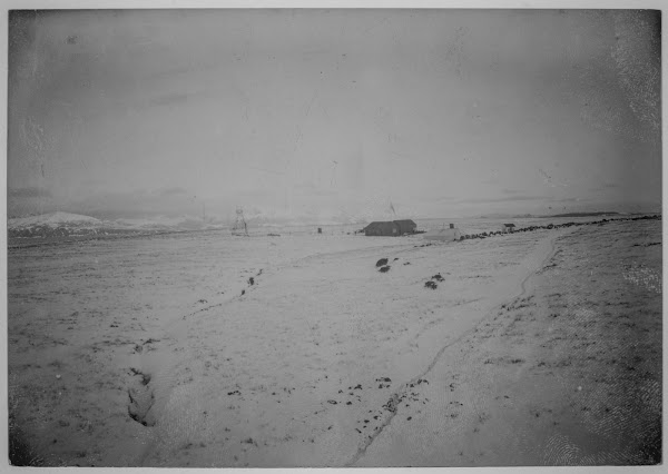
Isla Observatorio, Tierra del Fuego geomagnetic observatory 1902-1917

 Isla Observatorio, Tierra del Fuego lighthouse

A chance discovery among some photographs in the BGS Geomagnetic archive included this interesting image of a lighthouse. After much searching, this was identified as the Isla Observatorio at the southern tip of Argentina.

The following photograph is a good match for the fifth photo down on this history of the island, further evidence that this set of photographs is indeed the observatory on Isla Observatorio.

 Isla Observatorio, Tierra del Fuego geomagnetic observatory

The Observatory was run by Lieutenant Commander Horacio Ballvé, who may be among the people pictured in the photo below.
Group photograph,  Isla Observatorio, Tierra del Fuego geomagnetic observatory

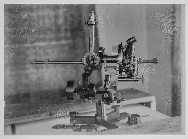
The following show the inside of the magnetic observatory with some of the instruments.
 Isla Observatorio, Tierra del Fuego geomagnetic observatory, instrument

 Isla Observatorio, Tierra del Fuego geomagnetic observatory, instruments

 Isla Observatorio, Tierra del Fuego geomagnetic observatory, instruments


 Isla Observatorio, Tierra del Fuego geomagnetic observatory, instruments

Lastly are two photographs, one showing a small ship and the other a beach with southern sea lions.
 Isla Observatorio, Tierra del Fuego geomagnetic observatory, ship


 Isla Observatorio, Tierra del Fuego, southern sea lions

HISTAMAR Las expediciones de investigacion arqueologica de Carlos P. Vairo y el Museo Maritimo de Ushuaia. Faro de isla Año Nuevo, Monumento Nacional Dec.64/99.

Grondona, Vero  La isla de los estados y la Isla Observatorio, Tierra del Fuego

Posted by Bob McIntosh, image processing Fergus MacTaggart, historical advice by Dr. Phil Stone


Tuesday, 12 April 2016

Eli Simpson Archive, British Speleological Association

Transcription of Eli Simpson's notes

Transcription of Eli Simpson's notes

The Eli Simpson Archive is a major collection of c 100 large format record books full of exploration accounts, newspaper cuttings, maps, surveys, photographs and published articles compiled by Eli Simpson and other members of the British Speleological Association. These extracts give a flavour of the material found in the albums. These items are from the Gaping Gill album.

The collection was held for many years at the British Cave Research Association Library but are now held on deposit at the  National Geological Repository at British Geological Survey, Keyworth for safekeeping.

Archives such as this one are not only important for the historical viewpoint but are also important as a source of information that supports current research into karst geohazards.

A short account of of the Eli Simpson Archive can be found  on the British Caving Library website. It has links to the full Gaping Gill volume and the the catalogue of the collection at the British Geological Survey.

Transcriptions from various caving log books and publications

Transcriptions from various caving log books and publications

Old newspaper cuttings

Old newspaper cuttings

 Eli Simpson's photographs

 Eli Simpson's photographs

Posted by Bob McIntosh

Saturday, 5 March 2016

Brora Colliery and tile kilns 1929

Brora Colliery and tile kilns 1929

Brora coalfield is the most northerly in the UK. 

A H.D. Hewitt photograph. From the Geologists' Association photograph collection held on deposit at the British Geological Survey


Posted by Bob McIntosh

Thursday, 10 December 2015

1912 British Association Field Excursion to Inchnadamph - signatures

Signed copy of the North-West Higlands Memoir
Signatures in the North-West Highlands Memoir

During recent stocktaking at Murchison House, British Geological Survey in Edinburgh, a copy of the North-west Highlands Memoir (Peach et al, 1907) was found in the Palaeontological Department. It has been rebound but is in excellent condition with little signs of use and no obvious foxing. The memoir contains detailed descriptions of the Lewisian, Torridonian, Moine and Cambrian-Ordovician rocks in the Durness to Kyle of Lochalsh area, summarising the results of the survey’s detailed work there in the late 19th century. This copy patently belonged to John Horne who was Assistant Director in the Geological Survey in Scotland from 1901 until his retirement in 1911.

The fly leaf of the memoir contains the signatures of 29 attendees of the renowned 1912 excursion to Assynt, which followed on from a British Association meeting in Dundee in mid-September that year. This excursion, led by Peach and Horne, was attended by 31notable European and British geologists (see Barber, 2010). The flyleaf also contains the signatures relating to an excursion undertaken in 1914, when John Horne took a further party to Assynt. Attendees included Sir Alexander and Lady (Rachel Workman) MacRobert, but also included the well-known geologists Reginald A Daly and Professor Molengraaf. Rachel Workman, the daughter of the noted American mountaineers William and Fanny Workman, was educated at Cheltenham Ladies College and gained a degree in geology from the University of London in 1902. She undertook research and published papers on alkaline igneous rocks (e.g. carbonatite and nepheline syenite) and was one of the first women to be elected a fellow of the Geological Society in 1919. Information on the MacRobert Trust, including her ladyship’s contribution to the Second World War, can be found at The MacRobert Trust. The memoir is to be archived by BGS.

Peach, B.N., Horne, J., Gunn, W., Clough, C.T., Hinxman, L.W. & Teall, J.J.H. (1907).  The geological structure of the northwest Highlands of Scotland.  Memoirs of the Geological Survey, U.K. 

Barber, A. J. 2010. Peach and Horne: the British Association excursion to Assynt September 1912. In Law, R.D., Butler, R.W.H., Holdsworth, R.E., Krabbendam, M. and Strachan, R.A. (editors) Continental Tectonics and Mountain Building: The Legacy of Peach and Horne. Geological Society, London, Special Publications, 335, 29-49.

Dr. John Mendum

Photograph of the entire party of the Assynt Excursion led by B.N. Peach and J. Horne, taken outside the Inchnadamph Hotel during September 1912. Excursion of the British Association for the Advancement of Science Meeting held in Dundee.

Photograph of the foreign visitors outside the Inchnadamph Hotel, Assynt Excursion held in September 1912, led by B.N. Peach and J. Horne. Excursion of the British Association for the Advancement of Science Meeting held in Dundee.

The 1914 Excursion. Photograph outside the Inchnadamph Hotel


Title page of the famous North-West Highlands Memoir
Title page of the famous North-west Highlands Memoir

Posted by Dr. John Mendum

Sunday, 22 November 2015

CALX carbonata (calcite) from British mineralogy by James Sowerby 1802-1817

  CALX carbonata; var. inversa. Inverse crystallized Carbonate of Lime. Plate no. 143
BGS Image ID: P704769


  CALX carbonata; var. inversa. Inverse crystallized Carbonate of Lime. Plate no. 143

From: Sowerby, James. 1802-1817. British Mineralogy: Or Coloured figures intended to elucidate the mineralogy of Great Britain. Plate from vol: 2. page no.81.

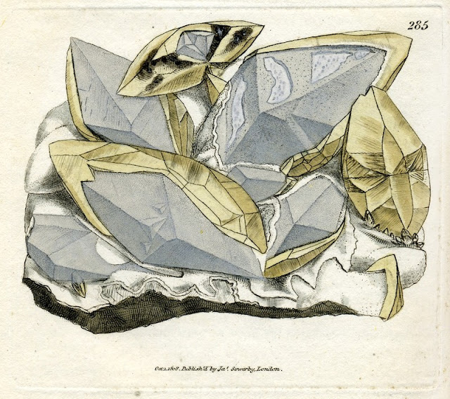
CALX carbonata. Crystallised Carbonate of Lime. Plate no. 285
BGS Image ID: P704911
CALX carbonata. Crystallised Carbonate of Lime. Plate no. 285

From: Sowerby, James. 1802-1817. British Mineralogy: Or Coloured figures intended to elucidate the mineralogy of Great Britain. Plate from vol: 3. page no.171. Modern name: Calcite. Location: Samples from the Dimple mine near Matlock.


CALX carbonata, var. metastatica. Metastatic crystallised Carbonate of Lime. Plate no. 314
BGS Image ID: P704940
CALX carbonata, var. metastatica. Metastatic crystallised Carbonate of Lime. Plate no. 314

From: Sowerby, James. 1802-1817. British Mineralogy: Or Coloured figures intended to elucidate the mineralogy of Great Britain. Plate from vol: 4. page no.19. Modern name: Calcite. Location: Sample collected in Derbyshire.

Friday, 23 October 2015

William Edmond Logan - A Geological Pioneer


A geologist with the then Ordnance Geological Survey (now the British Geological Survey) from its inception in 1835 and a contemporary of Henry de la BecheWilliam Edmond Logan went on the become the first Director of the Geological Survey of Canada which was formed in 1842. He remained in that post until 1869 when he was succeeded by another pioneer of the British Geological Survey, Alfred Richard Cecil Selwyn
 

William Edmond Logan (20 April 1798 - 22 June 1875)


Alfred Richard Cecil Selwyn
(20 July 1824 - 19 October 1902)
Henry Thomas De la Beche 
(10 February 1796 - 13 April 1855) 


From the British Geological Survey Library in Edinburgh, the following images show a couple of early examples of the Exploration Geologique du Canada: Rapport de Progrès or the Geological Survey of Canada: Report of Progress, the first published in 1846 with the progress from the year 1844. 


Exploration Geologique du Canada: Rapport de Progrès 


In a paper presented to the 'History of the Book in Canada’ Open Conference in May 2001: 
‘I wish these annual reports were at the devil’: William E. Logan and the publications of the Geological Survey of Canada,  Brian Shipley discusses the process undertaken by Logan in producing these Reports of Progress, revealing the objections Logan had in this approach to documenting the work of the Survey. 

Shipley's thesis; 'From Field to Fact: William E. Logan and the Geological Survey of Canada' is also available to download from Dalhousie University Library. 

A notable and honoured man, Logan is the subject of a Dinner Address made by J.M. Harrison at the Annual Dinner of the Geological Association of Canada on the 7th June 1963, which makes for an entertaining and informative read. 

Harrison, J.M. and Hall, E. (1963) Dinner Address: "William Edmond Logan". Proceedings of the Geological Association of Canada. Vol 15.  
                 
There are many routes for further exploration of the life and work of this celebrated Geologist, Written in Stone : William E. Logan and the Geological Survey of Canada is just one of them.


Posted by : Emma Illingworth