Sunday 1 June 2014

Groundwater drilling in Scotland

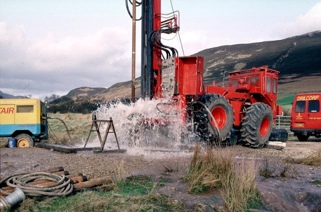
Hardthorn Road site, Dumfries, Dumfries and Galloway Region. Water strike during drilling for groundwater at Hardthorn Road.   The rotary drilling rig encountered only dry Permian breccia to 56 m. depth. At this level, a water-bearing fissure suddenly produced a surge of water at the surface. Other fissures were encountered at intervals to 130 m. depth. The final yield of water from the borehole was over 35 litres per second. The borehole is to be used by West of Scotland Water as part of the Dumfries public supply system. The Silurian hills can be seen in the background. These encircle the Permian aquifer in the floor of the basin.
BGS Image ID: P001426
Hardthorn Road site, Dumfries, Dumfries and Galloway Region. Water strike during drilling for groundwater at Hardthorn Road. 

The rotary drilling rig encountered only dry Permian breccia to 56 m. depth. At this level, a water-bearing fissure suddenly produced a surge of water at the surface. Other fissures were encountered at intervals to 130 m. depth. The final yield of water from the borehole was over 35 litres per second. The borehole is to be used by West of Scotland Water as part of the Dumfries public supply system. The Silurian hills can be seen in the background. These encircle the Permian aquifer in the floor of the basin.

Adjacent to the A70 road near Tarbrax, Strathclyde Region. A V-notch tank in use during a pumping test on an exploratory groundwater borehole.   The borehole was drilled by West of Scotland Water as an exercise to see whether groundwater could be used to supply the village of Tarbrax, and replace an unreliable surface stream source. The borehole, drilled into Upper Devonian sandstone and mudstone, yielded over 7 litres/second. The V-notch tank is used to measure the water flow, by comparing the height of water flowing over the V with flow rates in a reference table. The drill rig in the background was used to drill the borehole and install the electric pump to 50 m. depth.
BGS Image ID: P001434
 Adjacent to the A70 road near Tarbrax, Strathclyde Region. A V-notch tank in use during a pumping test on an exploratory groundwater borehole. 

The borehole was drilled by West of Scotland Water as an exercise to see whether groundwater could be used to supply the village of Tarbrax, and replace an unreliable surface stream source. The borehole, drilled into Upper Devonian sandstone and mudstone, yielded over 7 litres/second. The V-notch tank is used to measure the water flow, by comparing the height of water flowing over the V with flow rates in a reference table. The drill rig in the background was used to drill the borehole and install the electric pump to 50 m. depth.

Bridge Farm borehole, Machrie, Arran. An artesian, flowing, borehole drilled into the Permian sandstone aquifer at Machrie, Arran. A T.V. log of the borehole is being undertaken, using a BGS Land Rover.  The flow of water was measured at 10 litres/second, which makes it one of the highest naturally-flowing boreholes in Scotland. Most of the water is coming into the borehole at depths between 65 m. and 95 m. below ground level. The quality of the water is very high, and it is hoped that West of Scotland Water will use this source for most of the island's water supply before 2002.
BGS Image ID: P001440
Bridge Farm borehole, Machrie, Arran. An artesian, flowing, borehole drilled into the Permian sandstone aquifer at Machrie, Arran. A T.V. log of the borehole is being undertaken, using a BGS Land Rover.

The flow of water was measured at 10 litres/second, which makes it one of the highest naturally-flowing boreholes in Scotland. Most of the water is coming into the borehole at depths between 65 m. and 95 m. below ground level. The quality of the water is very high, and it is hoped that West of Scotland Water will use this source for most of the island's water supply before 2002.

Bridge Farm borehole, Machrie, Arran. Drilling a groundwater production borehole for West of Scotland Water at Machrie, Arran.  The drill rig is located close to the 'String' road from Brodick at a site chosen by the Hydrogeology Group of BGS. The rig is using an air flush hammer to drill through Permian sandstone. The compressor is seen at the left. Compressed air is sent down the drill rods to the hammer at the bottom of the borehole. The air operates the hammer and brings cuttings and water to the surface. The water flows away from the site to a stream. The 4-wheel drive tractor unit powers the rig and is highly manoeuvrable - useful for sites with problematical access.
BGS Image ID: P001441
Bridge Farm borehole, Machrie, Arran. Drilling a groundwater production borehole for West of Scotland Water at Machrie, Arran.

The drill rig is located close to the 'String' road from Brodick at a site chosen by the Hydrogeology Group of BGS. The rig is using an air flush hammer to drill through Permian sandstone. The compressor is seen at the left. Compressed air is sent down the drill rods to the hammer at the bottom of the borehole. The air operates the hammer and brings cuttings and water to the surface. The water flows away from the site to a stream. The 4-wheel drive tractor unit powers the rig and is highly maneuverable - useful for sites with problematical access.

Photographs by Derek Ball

Posted: Bob McIntosh

4 comments:

  1. The project is looking good. How is the surrounding environment reacting to the drilling? I'm wondering if the well will be used for public services or if it is a private project. Nonetheless, it looks like you're doing a great job. The water flowing from the surface looks lively. I hope the project continues to be a success. Good luck!

    Jermaine Ryan @ Loadcraft

    ReplyDelete
    Replies
    1. Many thanks for your interest and comments. The photographs were taken way back in the late 1990's so its not a current project. I'll ask our hydrogeologists if they have any comment in relation to your questions.

      Many thanks

      Bob

      Delete
  2. We offer various selection of sus304 stainless steel borehole pump for choice.

    ReplyDelete
  3. Drilling is a tool that is being used more and more frequently to preserve and restore the environment. Drilling is a generally non-intrusive technique for locating and removing radioactive and chemical wastes from the subsurface as well as for installing barriers to prevent contamination from spreading. Drilling technological advancements will increase the effectiveness of trash extraction and reduce the expense of cleaning procedures.

    ReplyDelete