Geological art by Dr. Elizabeth Pickett
 |
| BGS Image ID P551745 |
Geological art by Dr. Elizabeth Pickett, (North Pennines AONB, formerly of the British Geological Survey)
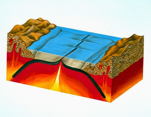
Gouache painting showing creation and destruction of oceanic crust. The painting shows how oceanic crust (shown in black) is created and destroyed. Magma (molten rock) is erupted along a mid-ocean ridge where it solidifies to become new oceanic crust. As more oceanic crust is created in this way the older, cooler crust moves away from the ridge and millions of years later may eventually be subducted beneath the continents at one or both sides of the ocean. Subduction is the process in which oceanic crust descends into the Earth's mantle. When subduction occurs at the edges of continents (as in this painting) it is marked by major oceanic trenches and the formation of chains of volcanoes known as volcanic arcs in the overlying continent (e.g. the Andes). The processes shown in this painting form part of the theory of plate tectonics. In this theory it is recognised that the Earth's surface is fragmented into tectonic plates (which carry both oceans and continents), which are continually moving across the surface of the planet. The boundaries of these plates interact with each other and are the sites of subduction zones, mid-ocean ridges (both shown in the picture), rift valleys, continental collision zones and transform faults.
 |
| BGS Image ID: P551755 |
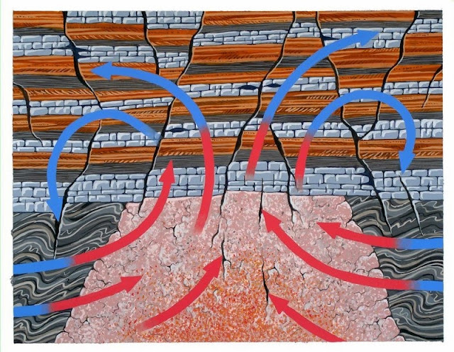
Gouache painting of mineralizing fluids. This painting shows how mineral veins in the North Pennines were formed. Mineral-rich waters (represented by the arrows), heated by the Weardale Granite intrusion circulated through cracks and faults in the overlying rocks (a sequence of Carboniferous limestones, shales and sandstones), depositing minerals as they cooled. The mineral veins in the North Pennines area were formed from deep saline water solutions which contained dissolved minerals. These contained iron, lead and copper minerals which were dissolved from surrounding rocks, including the Weardale Granite. The granite acted as a 'heat engine', warming the water and causing it to flow in a convection circuit along faults and fissures. As the fluids cooled, the dissolved minerals crystallized as crusts on the fissure walls. The North Pennines area in northern England has been designated an Area of Outstanding Natural Beauty and is also the site of Britain's first 'European Geopark'. The area is one of high fells, open moorland and wide dales. The unique character of the area owes much to human activity over hundreds of years, especially in relation to mining of the mineral deposits in the rocks.
 |
| BGS Image ID: P551756 |
Gouache painting showing block diagram of Pennine escarpment. This painting shows the main features of the Pennine escarpment. The North Pennine hills (on the right) are composed of horizontal beds of Carboniferous rocks. These rocks rest on older, folded Ordovician slates and volcanic rocks. Faults separate the escarpment from the red Permo-Triassic sandstones of the Vale of Eden. The terracing on the North Pennine hills is the result of weathering of a sequence of alternately hard and soft Carboniferous rocks. This sequence is composed of sandstone, shale and limestone; the harder limestone layers clearly stand out on the hillsides. The Weardale Granite lies beneath this sequence. The North Pennines area in northern England has been designated an Area of Outstanding Natural Beauty and is also the site of Britain's first 'European Geopark'. The area is one of high fells, open moorland and wide dales. The unique character of the area owes much to human activity over hundreds of years, especially in relation to mining of the mineral deposits in the rocks.
Posted by Bob McIntosh


No comments:
Post a Comment