Wednesday, 10 April 2013

Travelling in style, at Newlands Corner, Geologists' Association Motor excursion in Surrey, June 6th 1914

Geologists' Association Motor excursion in Surrey, June 6th 1914. At Newlands Corner.
BGS image ID: P804705
Geologists' Association Motor excursion in Surrey, June 6th 1914. At Newlands Corner.

From the Geologists' Association 'Carreck Archive'

Does anyone know the make of coach?

Bob McIntosh

Tuesday, 9 April 2013

Mica processing at the Pitlochry Depot, Perthshire. 1945.


Processing of Scottish mica. Pitlochry Depot (January 1945). Perthshire. Cutting and trimming mica at the Sorting Factory.
BGS image ID: P000163
Processing of Scottish mica. Pitlochry Depot (January 1945). Perthshire. Cutting and trimming mica at the Sorting Factory.

The split mica sheets are trimmed of all flaws, structural imperfections or, less serious, inclusions. The cutting knife is held at a low angle to the cleavage so the plates are consequently bevelled. The workers can clearly be seen using their knives. Processing of mica involved three stages, 1. rough cobbing, 2. splitting, 3. trimming. It does not undergo any other process of treatment or concentration before it is ready for use.


Processing of Scottish mica. Pitlochry Depot (January 1945). Perthshire. Plates of mica illustrating the various commercial grades.
BGS image ID: P000185
Plates of mica illustrating the various commercial grades. 

The photograph shows eight grades of mica. One to four are grades of staining. Five to seven are grades of spotting. Eight is a mica showing zoning, a structural imperfection. Note the re-entrant angles on three and four where imperfections have been cut out. Mica is graded for commercial purposes according to type, colour and freedom from staining. The primary division is into Muscovite or White Mica and Phlogopite or Amber Mica. Muscovite is subdivided into two types 'Ruby' and 'Green' types. Both are colourless when less than 0.5 mm. but when greater than this size they have reddish and greenish tinges respectively.

Production from the Pitlochry factory totalled 7,122 lbs. of block mica in addition 85 tons of scrap mica, resulting from the dressing operations, was sold. Mica, during wartime, became a mineral of high strategic value, an essential war material which due to its unique physical properties rendered it indispensable as an insulating medium in the manufacture of many types of electrical, radio and telephone equipment.

Bob McIntosh

Monday, 8 April 2013

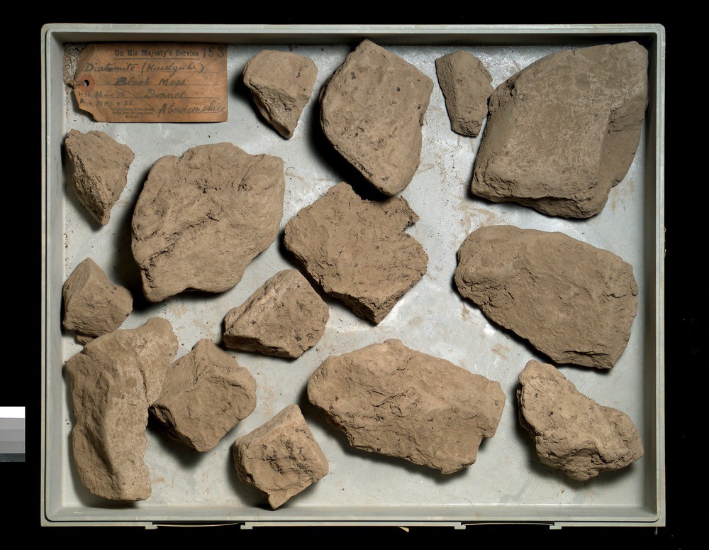
Diatomite from the Muir of Dinnet, Ballater, Aberdeenshire.


A collection of specimens of diatomite from the deposit at Muir of Dinnet near Ballater, Aberdeenshire.
BGS image ID: P527720
A collection of specimens of diatomite from the deposit at Muir of Dinnet near Ballater, Aberdeenshire. 

Diatomite is a whitish, fine-grained substance consisting essentially of siliceous skeletons or frustrules of diatoms, minute organisms. British Geological Survey Petrology Collection sample number MC 7497. 

Most diatomite is laid down in freshwater lakes and swamps. This deposit was first recognized as diatomaceous by the Rev. George Davidson in about 1880. An analysis by Mr. Ivison Macadam showed that the inorganic portion contained 82.96 per cent silica, 5.5 per cent iron oxide, 2.1 per cent alumina and 2.93 magnesia. It compared with the specimens of German kieselguhr for purity. 

The deposit was explored by sinking shafts and it was estimated that the deposit contained 800,000 cubic yards of kieselguhr, 6 cubic yards of which, when fully dried would make a ton. The diatomite occurred at a number of localities: Black Moss, 162 acres in area, 15 feet to a few inches thick and 800,000 cubic yards; Ordie Moss, originally 8 acres but now worked out; Loch Kinnord; Haugh of Milton 10-12 acres, one foot thick 17,700 cubic yards; Auchnarran, 46 acres, 15 inches thick 92,700 cubic yards.

Almost all the diatomite went to the Ardeer explosive works in Ayrshire where it was used as a carrier or absorbent for nitroglycerine in dynamite manufacture. (Good diatomite will absorb four times its weight in water.)


Bob McIntosh

Sunday, 7 April 2013

Descending a denehole at Hangman's Wood, West Thurrock, Essex.

Descending a Denehole at Hangman's Wood at West Thurrock, Essex. 1908. From the GA 'Carreck Archive'
BGS Image ID: P805290

Descending a Denehole at Hangman's Wood at West Thurrock, Essex. 1908. From the GA 'Carreck Archive'

'In the course of ploughing this field the horse's feet broke through the surface. We procured a rope and the pole of a waggon and investigated the interior. The shaft descended through about 12 feet of Thanet Sand and entered into a beehive-shaped chamber about 20 ft. high. These deneholes were formed in getting the chalk in past ages for marling the land.'

Deneholes are typically about 60 feet deep with steps cut into the side of the shaft to allow climbing in and out. At the bottom they open out to a domed chamber, often with sub-chambers.

It is though that chalk was mined this way from pre-Roman times.

Photographer: T.W. Reader

Bob McIntosh

Saturday, 6 April 2013

Geologists' Association Excursion to Derbyshire, August 3rd 1914. Bonsall.

Group photograph, Geologists' Association Excursion to Derbyshire, August 3rd 1914. Bonsall.
BGS Image ID: P804358
Group photograph, Geologists' Association Excursion to Derbyshire, August 3rd 1914. Bonsall.

From the Geologists' Association 'Carreck Archive' currently being digitized at the British Geological Survey.

Bonsall is an old mining town. Lead was mined there and in nearby Wirksworth from Roman times. The market cross is medieval and is the tallest market cross in Derbyshire. John Wesley, founder of the Methodist movement preached from the top step. The King's Head public house on the far right dates back to 1677.

Bob McIntosh

Friday, 5 April 2013

Hantergantick Quarry, Cornwall. Thermal lance demonstration.

Hantergantick Quarry, Cornwall. Thermal lance demonstration.
BGS image ID: P539881
Hantergantick Quarry. Jet cutting demonstration using a thermal lance to cut granite with heat and sound energy. Early 1960s. Note gas cylinders in the background. Hugh O'Neill Collection.

The temperature is believed to reach 3000 degrees C.

Bob McIntosh

Thursday, 4 April 2013

Geological Survey of England and Wales 1:63,360 geological map series [Old Series] Sheet 34 - map extract


Extract of the Swindon area from the Geological Survey of England and Wales 1:63,360 geological map series [Old Series] Sheet 34 [Stroud, Cirencester, Fairford, Swindon, Chippenham, Marlborough Downs.] Decr. 1857. A beautifully hand-coloured map painted with watercolours.

The map is one example from c. 2,200 maps and sections dating from 1832 and released yesterday on the British Geological Survey OpenGeoscience service.

Bob McIntosh

Wednesday, 3 April 2013

Three Vickers Victoria aircraft unloading cargo. Royal Air Force at Dodoma, 1929.


Royal Air Force at Dodoma. Three Vickers Victoria aircraft unloading cargo, 1929. E.O. Teale photograph collection.
BGS image ID: P776210
Royal Air Force at Dodoma. Three Vickers Victoria aircraft unloading cargo, 1929. E.O. Teale photograph collection.

Bob McIntosh

Tuesday, 2 April 2013

The Grizzly Bears - the dining club of the geologists of the Geological Survey of Scotland. 1869.


The Grizzly Bears - the dining club of the geologists of the Geological Survey of Scotland. 1869.

The Grizzly Bears - the dining club of the geologists of the Geological Survey of Scotland. Their first meeting was in Dejay's Hotel in Edinburgh on February 16th 1869 and they continued up to 1970. The records of the dinners are held in the three volume 'Dinner Books', an amazing informal record of the songs, recitations, sketches and other ephemera relating to activities at the dinners. The usually humorous songs and recitations were written by the geologists themselves and they relate to geology, their work, and life in the Geological Survey.

Dining clubs were common in late-Victorian Britain. A dining club based in London for the England and Wales staff of the Survey was called 'The Royal Hammerers'. 

Note the Grizzly Bear at the head of the table - he is holding a geological hammer - no doubt to call order!

Bob McIntosh

Monday, 1 April 2013

The Rock and Spindle, 3.621 km. east of St. Andrews. Fife Region.

The 'Rock and Spindle', 3.621 km. east of St. Andrews. Fife Region
BGS image ID: P000250
The 'Rock and Spindle', 3.621 km. east of St. Andrews. Fife Region. The prominent low stack in the vicinity of the Kinkell Ness Vent is a volcanic 'neck' within the Carboniferous Calciferous Sandstone Series. The radiating spokes of the 'Spindle' are columnar jointed basanite (basalt) and are relatively free from xenoliths while the rest of the stack into which the spindle grades without any sign of contact is basalt containing many xenoliths, igneous towards the centre and masses of sedimentary rocks, sandstones and limestones up to two metres across around the outside.

BGS old photograph number: B474. Whole Plate.
Photographer: R. Lunn
Date of photograph: 1895

Bob McIntosh