Monday 30 June 2014

PLUMBUM Galaena. Sulphure of Lead; Galena. Plate no. 24. From: Sowerby, James. 1802-1817. British Mineralogy

PLUMBUM Galaena. Sulphure of Lead; Galena. Plate no. 24. From: Sowerby, James. 1802-1817. British Mineralogy: Or Coloured figures intended to elucidate the mineralogy of Great Britain. Plate from vol: 1. page no.55. Modern name: Galena. Location: Collected found in Derbyshire.
BGS Image ID: P704650

PLUMBUM Galaena. Sulphure of Lead; Galena. Plate no. 24. From: Sowerby, James. 1802-1817. British Mineralogy: Or Coloured figures intended to elucidate the mineralogy of Great Britain. Plate from vol: 1. page no. 55. Modern name: Galena. Location: Collected found in Derbyshire.

Posted by Bob McIntosh

Sunday 22 June 2014

Settle Lime, November 1960. The new Priest kilns.

Settle Lime, Nov 1960, north of Settle, Ingleborough, Horton and Threshfield. The new kilns
BGS Image ID: P538126
Settle Lime, Nov 1960, north of Settle, Ingleborough, Horton and Threshfield. The new kilns. Priest kilns.

From the Hugh O'Neill collection.

Posted by Bob McIntosh

Sunday 15 June 2014

Crossing water, E.O. Teale Collection

Crossing a river by bridge,  Mbeya, Tanganyika Territory, 1928. E.O. Teale Collection
BGS Image ID: P776556
Crossing a river by bridge,  Mbeya, Tanganyika Territory, 1928.

Crossing a river by raft. E.O. Teale Collection
BGS Image ID: P776485
Crossing a river by raft

Crossing a river by precarious footbridge. E.O. Teale Collection
BGS Image ID: P776490
Crossing a river by precarious footbridge

Wading a river. E.O. Teale Collection
BGS Image ID: P776527
Wading across a river

Photographs are from the E.O. Teale Collection. 

Also see :


River transport by traditional 'dugout' canoe. Gold Coast. 1919

Posted by Bob McIntosh


Sunday 8 June 2014

Land Rover photographs in the BGS archives

A set of photographs for Land Rover fans!

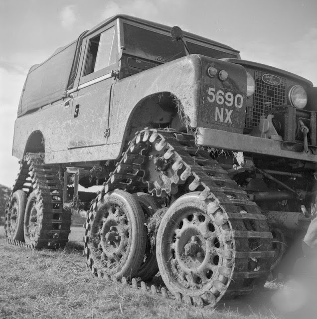
Track conversion close-up. 4 independent tracks, the front two being steered through the normal steering system. The cost of the kit is £650.
BGS Image ID: P539250
Track conversion close-up. 4 independent tracks, the front two being steered through the normal steering system. The cost of the kit was £650.

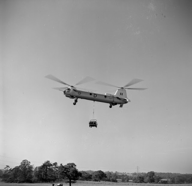
Land Rover demonstation, Solihull. Bristol Type 192 Belvedere helicopter carrying a Land Rover.
BGS ImageID:  P539249
Land Rover demonstation, Solihull. Bristol Type 192 Belvedere helicopter carrying a Land Rover.

Land Rover demonstation, Solihull. Large wheel conversion.
BGS Image ID: P539252
Land Rover demonstation, Solihull. Large wheel conversion.

Land Rover demonstation, Solihull. Rail conversion. Road wheels have been replaced by Duthene-treated tyres, this gives very good traction. One vehicle pulled 52 tons of wagons.
BGS Image ID: P539253
Land Rover demonstation, Solihull. Rail conversion. Road wheels have been replaced by Duthene-treated tyres, this gives very good traction. One vehicle pulled 52 tons of wagons.

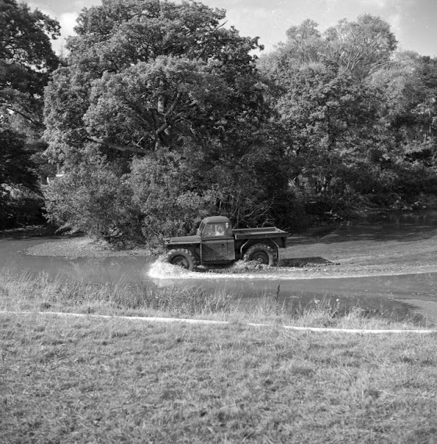
Plant demonstration Soil Fertility Limited. Crop spraying Land Rover with hovercraft assist.
BGS Image ID: P539860
Plant demonstration Soil Fertility Limited. Crop spraying Land Rover with hovercraft assist.


Plant demonstration Soil Fertility Limited. Crop spraying Land Rover with hovercraft assist.
BGS Image ID: P539861
Plant demonstration Soil Fertility Limited. Crop spraying Land Rover with hovercraft assist.

Photographs from the Mr. Hugh O'Neill Collection. Most of the photographs in this collection are of quarries in the UK. Dates are c. 1961.

Posted by Bob McIntosh

Sunday 1 June 2014

Groundwater drilling in Scotland

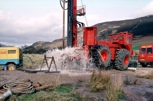
Hardthorn Road site, Dumfries, Dumfries and Galloway Region. Water strike during drilling for groundwater at Hardthorn Road.   The rotary drilling rig encountered only dry Permian breccia to 56 m. depth. At this level, a water-bearing fissure suddenly produced a surge of water at the surface. Other fissures were encountered at intervals to 130 m. depth. The final yield of water from the borehole was over 35 litres per second. The borehole is to be used by West of Scotland Water as part of the Dumfries public supply system. The Silurian hills can be seen in the background. These encircle the Permian aquifer in the floor of the basin.
BGS Image ID: P001426
Hardthorn Road site, Dumfries, Dumfries and Galloway Region. Water strike during drilling for groundwater at Hardthorn Road. 

The rotary drilling rig encountered only dry Permian breccia to 56 m. depth. At this level, a water-bearing fissure suddenly produced a surge of water at the surface. Other fissures were encountered at intervals to 130 m. depth. The final yield of water from the borehole was over 35 litres per second. The borehole is to be used by West of Scotland Water as part of the Dumfries public supply system. The Silurian hills can be seen in the background. These encircle the Permian aquifer in the floor of the basin.

Adjacent to the A70 road near Tarbrax, Strathclyde Region. A V-notch tank in use during a pumping test on an exploratory groundwater borehole.   The borehole was drilled by West of Scotland Water as an exercise to see whether groundwater could be used to supply the village of Tarbrax, and replace an unreliable surface stream source. The borehole, drilled into Upper Devonian sandstone and mudstone, yielded over 7 litres/second. The V-notch tank is used to measure the water flow, by comparing the height of water flowing over the V with flow rates in a reference table. The drill rig in the background was used to drill the borehole and install the electric pump to 50 m. depth.
BGS Image ID: P001434
 Adjacent to the A70 road near Tarbrax, Strathclyde Region. A V-notch tank in use during a pumping test on an exploratory groundwater borehole. 

The borehole was drilled by West of Scotland Water as an exercise to see whether groundwater could be used to supply the village of Tarbrax, and replace an unreliable surface stream source. The borehole, drilled into Upper Devonian sandstone and mudstone, yielded over 7 litres/second. The V-notch tank is used to measure the water flow, by comparing the height of water flowing over the V with flow rates in a reference table. The drill rig in the background was used to drill the borehole and install the electric pump to 50 m. depth.

Bridge Farm borehole, Machrie, Arran. An artesian, flowing, borehole drilled into the Permian sandstone aquifer at Machrie, Arran. A T.V. log of the borehole is being undertaken, using a BGS Land Rover.  The flow of water was measured at 10 litres/second, which makes it one of the highest naturally-flowing boreholes in Scotland. Most of the water is coming into the borehole at depths between 65 m. and 95 m. below ground level. The quality of the water is very high, and it is hoped that West of Scotland Water will use this source for most of the island's water supply before 2002.
BGS Image ID: P001440
Bridge Farm borehole, Machrie, Arran. An artesian, flowing, borehole drilled into the Permian sandstone aquifer at Machrie, Arran. A T.V. log of the borehole is being undertaken, using a BGS Land Rover.

The flow of water was measured at 10 litres/second, which makes it one of the highest naturally-flowing boreholes in Scotland. Most of the water is coming into the borehole at depths between 65 m. and 95 m. below ground level. The quality of the water is very high, and it is hoped that West of Scotland Water will use this source for most of the island's water supply before 2002.

Bridge Farm borehole, Machrie, Arran. Drilling a groundwater production borehole for West of Scotland Water at Machrie, Arran.  The drill rig is located close to the 'String' road from Brodick at a site chosen by the Hydrogeology Group of BGS. The rig is using an air flush hammer to drill through Permian sandstone. The compressor is seen at the left. Compressed air is sent down the drill rods to the hammer at the bottom of the borehole. The air operates the hammer and brings cuttings and water to the surface. The water flows away from the site to a stream. The 4-wheel drive tractor unit powers the rig and is highly manoeuvrable - useful for sites with problematical access.
BGS Image ID: P001441
Bridge Farm borehole, Machrie, Arran. Drilling a groundwater production borehole for West of Scotland Water at Machrie, Arran.

The drill rig is located close to the 'String' road from Brodick at a site chosen by the Hydrogeology Group of BGS. The rig is using an air flush hammer to drill through Permian sandstone. The compressor is seen at the left. Compressed air is sent down the drill rods to the hammer at the bottom of the borehole. The air operates the hammer and brings cuttings and water to the surface. The water flows away from the site to a stream. The 4-wheel drive tractor unit powers the rig and is highly maneuverable - useful for sites with problematical access.

Photographs by Derek Ball

Posted: Bob McIntosh