Sunday 25 May 2014

Geological art by Dr. Elizabeth Pickett

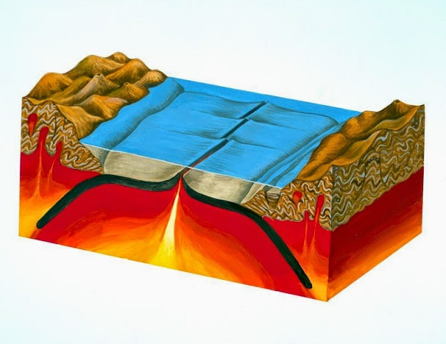
Gouache painting showing creation and destruction of oceanic crust.  The painting is the first of two, showing how oceanic crust (shown in black) is created and destroyed. Magma (molten rock) is erupted along a mid-ocean ridge where it solidifies to become new oceanic crust. As more oceanic crust is created in this way the older, cooler crust moves away from the ridge and millions of years later may eventually be subducted beneath the continents at one or both sides of the ocean. Subduction is the process in which oceanic crust descends into the Earth's mantle. When subduction occurs at the edges of continents (as in this painting) it is marked by major oceanic trenches and the formation of chains of volcanoes known as volcanic arcs in the overlying continent (e.g. the Andes). The processes shown in this painting form part of the theory of plate tectonics. In this theory it is recognised that the Earth's surface is fragmented into tectonic plates (which carry both oceans and continents), which are continually moving across the surface of the planet. The boundaries of these plates interact with each other and are the sites of subduction zones, mid-ocean ridges (both shown in the picture), rift valleys, continental collision zones and transform faults.
BGS Image ID P551745
Geological art by Dr. Elizabeth Pickett, (North Pennines AONB, formerly of the British Geological Survey)

Gouache painting showing creation and destruction of oceanic crust.  The painting shows how oceanic crust (shown in black) is created and destroyed. Magma (molten rock) is erupted along a mid-ocean ridge where it solidifies to become new oceanic crust. As more oceanic crust is created in this way the older, cooler crust moves away from the ridge and millions of years later may eventually be subducted beneath the continents at one or both sides of the ocean. Subduction is the process in which oceanic crust descends into the Earth's mantle. When subduction occurs at the edges of continents (as in this painting) it is marked by major oceanic trenches and the formation of chains of volcanoes known as volcanic arcs in the overlying continent (e.g. the Andes). The processes shown in this painting form part of the theory of plate tectonics. In this theory it is recognised that the Earth's surface is fragmented into tectonic plates (which carry both oceans and continents), which are continually moving across the surface of the planet. The boundaries of these plates interact with each other and are the sites of subduction zones, mid-ocean ridges (both shown in the picture), rift valleys, continental collision zones and transform faults.

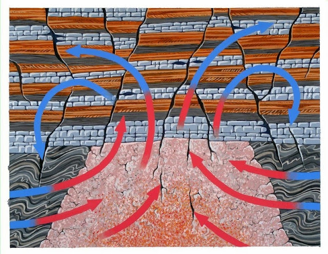
Gouache painting of mineralizing fluids. This painting shows how mineral veins in the North Pennines were formed. Mineral-rich waters (represented by the arrows), heated by the Weardale Granite intrusion circulated through cracks and faults in the overlying rocks (a sequence of Carboniferous limestones, shales and sandstones), depositing minerals as they cooled. The mineral veins in the North Pennines area were formed from deep saline water solutions which contained dissolved minerals. These contained iron, lead and copper minerals which were dissolved from surrounding rocks, including the Weardale Granite. The granite acted as a 'heat engine', warming the water and causing it to flow in a convection circuit along faults and fissures. As the fluids cooled, the dissolved minerals crystallized as crusts on the fissure walls. The North Pennines area in northern England has been designated an Area of Outstanding Natural Beauty and is also the site of Britain's first 'European Geopark'. The area is one of high fells, open moorland and wide dales. The unique character of the area owes much to human activity over hundreds of years, especially in relation to mining of the mineral deposits in the rocks.
BGS Image ID: P551755
Gouache painting of mineralizing fluids. This painting shows how mineral veins in the North Pennines were formed. Mineral-rich waters (represented by the arrows), heated by the Weardale Granite intrusion circulated through cracks and faults in the overlying rocks (a sequence of Carboniferous limestones, shales and sandstones), depositing minerals as they cooled. The mineral veins in the North Pennines area were formed from deep saline water solutions which contained dissolved minerals. These contained iron, lead and copper minerals which were dissolved from surrounding rocks, including the Weardale Granite. The granite acted as a 'heat engine', warming the water and causing it to flow in a convection circuit along faults and fissures. As the fluids cooled, the dissolved minerals crystallized as crusts on the fissure walls. The North Pennines area in northern England has been designated an Area of Outstanding Natural Beauty and is also the site of Britain's first 'European Geopark'. The area is one of high fells, open moorland and wide dales. The unique character of the area owes much to human activity over hundreds of years, especially in relation to mining of the mineral deposits in the rocks.

Gouache painting showing block diagram of Pennine escarpment. This painting shows the main features of the Pennine escarpment. The North Pennine hills (on the right) are composed of horizontal beds of Carboniferous rocks. These rocks rest on older, folded Ordovician slates and volcanic rocks. Faults separate the escarpment from the red Permo-Triassic sandstones of the Vale of Eden. The terracing on the North Pennine hills is the result of weathering of a sequence of alternately hard and soft Carboniferous rocks. This sequence is composed of sandstone, shale and limestone; the harder limestone layers clearly stand out on the hillsides. The Weardale Granite lies beneath this sequence. The North Pennines area in northern England has been designated an Area of Outstanding Natural Beauty and is also the site of Britain's first 'European Geopark'. The area is one of high fells, open moorland and wide dales. The unique character of the area owes much to human activity over hundreds of years, especially in relation to mining of the mineral deposits in the rocks.
BGS Image ID: P551756
Gouache painting showing block diagram of Pennine escarpment. This painting shows the main features of the Pennine escarpment. The North Pennine hills (on the right) are composed of horizontal beds of Carboniferous rocks. These rocks rest on older, folded Ordovician slates and volcanic rocks. Faults separate the escarpment from the red Permo-Triassic sandstones of the Vale of Eden. The terracing on the North Pennine hills is the result of weathering of a sequence of alternately hard and soft Carboniferous rocks. This sequence is composed of sandstone, shale and limestone; the harder limestone layers clearly stand out on the hillsides. The Weardale Granite lies beneath this sequence. The North Pennines area in northern England has been designated an Area of Outstanding Natural Beauty and is also the site of Britain's first 'European Geopark'. The area is one of high fells, open moorland and wide dales. The unique character of the area owes much to human activity over hundreds of years, especially in relation to mining of the mineral deposits in the rocks.

Posted by Bob McIntosh

Monday 19 May 2014

Louis Bernacchi notebook. British National Antarctic Expedition, 1901–04


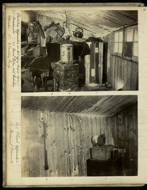
Photographs from the 'Pendulum observations' notebook by Louis Bernacchi from the 'Discovery' Antarctic Expedition 1902-1903. Bernacchi was recruited as physicist for Captain R.F. Scott's British National Antarctic Expedition (1901-04).

This journal records Pendulum Observations and includes certificates and notes.  The two photographs show the interior of a hut in 1902 with the pendulum apparatus within it. The photographs are annotated with details of the equipment. The image also includes other items held in the hut, including snow shoes, a kettle and an appetizing looking crate of ‘Special Cabin Biscuits’.


Title page of Bernacchi's Pendulum observations notebook.


Sample page from Bernacchi's Pendulum observations notebook.

Pendulum observations were undertaken within a vacuum apparatus to determine the local value of gravity which helps indicate the extent to which the earth is oblate. There were three pendulums and each observation took many hours.


Posted by Fiona Menzies and Bob McIntosh
Sunday 11 May 2014

Standing stones and burial chambers, geoarchaeology

Standing Stones of Stenness, south-east end of Loch of Stenness. Orkney. The henge and stone circle have radiocarbon dates suggesting that Stenness was constructed during the 3rd. millennium B.C. Four thin, unshaped flagstones now survive, the tallest over five metres high; it is thought that there were originally twelve stones set in a circle about 30 metres in diameter. Ploughing has almost levelled the henge earthworks but the circle once stood within a ditch and bank, with an entrance causeway to the north. The henge and stone circle of Stenness together with the Ring of Brodgar and associated outlying stones and burial mounds form part of a great ceremonial complex in the heart of Orkney, comparable to Callanish on Lewis in the Western Isles and to Stonehenge on Salisbury Plain in Wiltshire.
BGS Image ID: P000605
Standing Stones of Stenness, south-east end of Loch of Stenness. Orkney. The henge and stone circle have radiocarbon dates suggesting that Stenness was constructed during the 3rd. millennium B.C. Four thin, unshaped flagstones now survive, the tallest over five metres high; it is thought that there were originally twelve stones set in a circle about 30 metres in diameter. Ploughing has almost levelled the henge earthworks but the circle once stood within a ditch and bank, with an entrance causeway to the north. The henge and stone circle of Stenness together with the Ring of Brodgar and associated outlying stones and burial mounds form part of a great ceremonial complex in the heart of Orkney, comparable to Callanish on Lewis in the Western Isles and to Stonehenge on Salisbury Plain in Wiltshire.

Dwarfie Stane, north-west Hoy, Orkney. The Dwarfie Stane is a neolithic burial chamber hollowed out from a solid block of cross-bedded Hoy Sandstone (Upper Old Red Sandstone). It is thought that the Dwarfie Stane is derived from cliffs on the downthrow side of the Bring Fault where massive beds of yellow or more rarely red sandstones of the Hoy Sandstone are found (the escarpment in the background).
BGS Image ID: P000597
Dwarfie Stane, north-west Hoy, Orkney. The Dwarfie Stane is a neolithic burial chamber hollowed out from a solid block of cross-bedded Hoy Sandstone (Upper Old Red Sandstone). It is thought that the Dwarfie Stane is derived from cliffs on the downthrow side of the Bring Fault where massive beds of yellow or more rarely red sandstones of the Hoy Sandstone are found (the escarpment in the background).

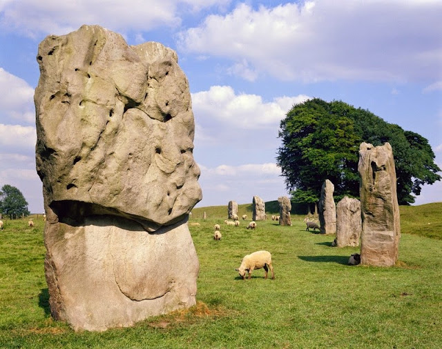
Avebury stone circles, Wiltshire. Avebury is the largest 'henge' or stone circle in Britain.The standing stones of the Avebury circles, which range from 0.5 m. to 6 m. in height and number over 150 in total, are pale grey, silica-cemented sandstones of Tertiary age commonly known as sarsen stones. The source of the sarsen stone used in the megalithic site at Avebury is believed to be the Marlborough Downs. The stones were formed by the cementation of loose sands in the remnants of the Tertiary succession that once covered the downs. Some of the stones were revealed by weathering but others were probably dug from the succession and transported to Avebury. Sarsen stones are widely used in southern Britain at prehistoric sites including Avebury, Long Kennet and Stonehenge. Although best known as standing stones the sandstones were once extensively quarried on the Marlborough Downs for building stone. However, many standing stones are also believed to have been removed from the prehistoric structures for building purposes in earlier times.
BGS Image ID: P211066
Avebury stone circles, Wiltshire. Avebury is the largest 'henge' or stone circle in Britain.The standing stones of the Avebury circles, which range from 0.5 m. to 6 m. in height and number over 150 in total, are pale grey, silica-cemented sandstones of Tertiary age commonly known as sarsen stones. The source of the sarsen stone used in the megalithic site at Avebury is believed to be the Marlborough Downs. The stones were formed by the cementation of loose sands in the remnants of the Tertiary succession that once covered the downs. Some of the stones were revealed by weathering but others were probably dug from the succession and transported to Avebury. Sarsen stones are widely used in southern Britain at prehistoric sites including Avebury, Long Kennet and Stonehenge. Although best known as standing stones the sandstones were once extensively quarried on the Marlborough Downs for building stone. However, many standing stones are also believed to have been removed from the prehistoric structures for building purposes in earlier times.

Wayland's Smithy long barrow, Berkshire. Looking north. The Chalk downland area known as the Ridgeway, forming the southern edge of the Vale of the White Horse, is one of several areas littered with sarsen sandstone blocks. The sandstones are the remnants of a former Tertiary sedimentary cover and in some areas may be very abundant as at Clatford Bottom. Wayland's Smithy, named after the Saxon god of metalworking, is a neolithic long barrow constructed of silica-cemented, sandstone blocks known as sarsen stones or sometimes greywethers.
BGS Image ID: P211066
Wayland's Smithy long barrow, Berkshire. Looking north. The Chalk downland area known as the Ridgeway, forming the southern edge of the Vale of the White Horse, is one of several areas littered with sarsen sandstone blocks. The sandstones are the remnants of a former Tertiary sedimentary cover and in some areas may be very abundant as at Clatford Bottom. Wayland's Smithy, named after the Saxon god of metalworking, is a neolithic long barrow constructed of silica-cemented, sandstone blocks known as sarsen stones or sometimes greywethers. 

See also Stonehenge on BGS Geoheritage

Posted by Bob McIntosh

Sunday 4 May 2014

Broughton Moor near Coniston, Cumbria - slate working

 Broughton Moor, Lakeland Green Slate, 7 miles south-west of Coniston, Cumbria. Excavator level - NCK 304 excavator.
BGS Image ID: P538078
Broughton Moor, Lakeland Green Slate, 7 miles south-west of Coniston, Cumbria. Excavator level - NCK 304 excavator.

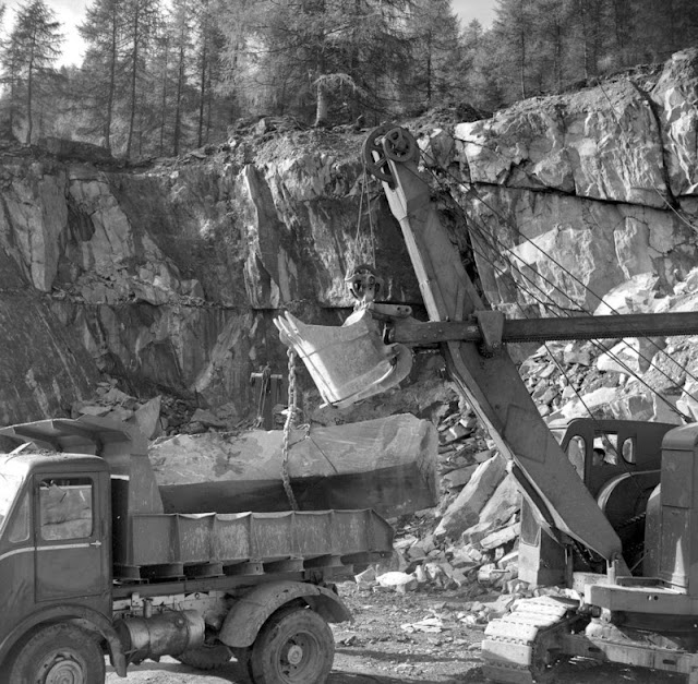
Broughton Moor. Green Slate Quarries, Spout Crag Quarry, 7 miles south-west of Coniston, Cumbria. Loading a large block in the quarry - NCK 304.
BGS Image ID: P538063
Broughton Moor. Green Slate Quarries, Spout Crag Quarry, 7 miles south-west of Coniston, Cumbria. Loading a large block in the quarry - NCK 304.

Broughton Moor, Lakeland Green Slate, 7 miles south-west of Coniston, Cumbria. Circular saw - Anderson saw.
BGS Image ID: P538093
Broughton Moor, Lakeland Green Slate, 7 miles south-west of Coniston, Cumbria. Circular saw - Anderson saw.

Broughton Moor, Lakeland Green Slate, 7 miles south-west of Coniston, Cumbria. Trimming roofing slate
BGS Image ID: P538101
Broughton Moor, Lakeland Green Slate, 7 miles south-west of Coniston, Cumbria. Trimming roofing slate

Broughton Moor, Lakeland Green Slate, 7 miles south-west of Coniston, Cumbria. Slab riving.
BGS Image ID: P538105
Broughton Moor, Lakeland Green Slate, 7 miles south-west of Coniston, Cumbria. Slab riving.

Broughton Moor, Lakeland Green Slate, 7 miles south-west of Coniston, Cumbria. Polishing
BGS Image ID P538115
Broughton Moor, Lakeland Green Slate, 7 miles south-west of Coniston, Cumbria. Polishing

The photographs are part of a large collection donated by Mr. Hugh O'Neill, former Special Correspondent for Quarry Manager Journal and Cement, Lime and Gravel in the early 1960s. The full set of Broughton Moor slate working images can be viewed on the BGS Geoscenic. image resource.

There may be discrepancies with some of the stated locations e.g. P538063 is listed as Spout Crag Quarry which was in Langdale not Broughton Moor.

Posted by Bob McIntosh