Tuesday 30 April 2013

Guestling Brickworks Ltd., Three Oaks, near Hastings

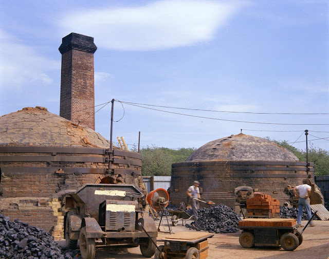
Guestling Brickworks Ltd., Three Oaks, near Hastings. Looking E. Firing of brick kilns. Specialist hand-made facing bricks are manufactured in this small brick-works. Silty loamy 'Head' is dug nearby and used as raw materials. The two kilns are of round down-draught type and are used alternately in weekly firing cycles, during which the bricks are raised to a temperature of 1200 C.
BGS image ID: P006801
Guestling Brickworks Ltd., Three Oaks, near Hastings. Looking E. Firing of brick kilns. Specialist hand-made facing bricks are manufactured in this small brick-works. Silty loamy 'Head' is dug nearby and used as raw materials. The two kilns are of round down-draught type and are used alternately in weekly firing cycles, during which the bricks are raised to a temperature of 1200 C.

Date of image: 1967

Bob McIntosh

Monday 29 April 2013

P J Salter's Imperial Service Medal


P J Salter's Imperial Service Medal
BGS image ID: P823785
This Imperial Service Medal was awarded to Peter John Salter who was the Housekeeper and Store Clerk at the Geological Museum. 

P J Salter
BGS image ID: P585025

Salter began working at the Museum in 1885 and retired in 1925. He moved to Vancouver, Canada where the medal was presented "for long and meritorious service" by the Lieutenant Governor.

Andrew L Morrison

Nullipore or coralline sand from Craig, near Plockton and Claigan, near Dunvegan, Scotland

Nullipore or coralline sand from Craig, two miles east of Plockton, near Kyle of Lochalsh. In certain areas the calcareous alga Lithothamnion calcarreum flourishes in great abundance and broken fragments of the thallus form dazzling, creamy-white beaches which are composed almost exclusively of this material.
BGS image ID: P527777
Nullipore or coralline sand from Craig, two miles east of Plockton, near Kyle of Lochalsh. In certain areas the calcareous alga Lithothamnion calcarreum flourishes in great abundance and broken fragments of the thallus form dazzling, creamy-white beaches which are composed almost exclusively of this material.  Lithothamnion calcarreum lives in the upper and lower sub-littoral zone. In places they have been dug for agricultural lime. Colonies have been found elsewhere in Scotland, especially on Skye near Dunvegan, particularly from three bays the largest of which is Camus Ban north of Rubha na Gairbhe.

British Geological Survey Petrology Collection sample number MC 7553.


Nullipore or coralline sand probably from the shore at Claigan, about four miles north of Dunvegan Castle. Coralline or nullipore sand is found in three small bays near Claigan. It consists of broken fragments of the calcareous algae Lithothamnion calcarreum.
BGS image ID: P527775
Nullipore or coralline sand probably from the shore at Claigan, about four miles north of Dunvegan Castle. Coralline or nullipore sand is found in three small bays near Claigan. It consists of broken fragments of the calcareous algae Lithothamnion calcarreum. It forms dazzling white beaches. The sand is coarsely granular and the fragments composing it have a marked coral-like appearance. The quantity varies somewhat from year to year depending on the incidence of storms. Camas Ban, the most southerly of the three bays, is accessible by road. Published figures (from 1956) estimated a minimum of 2,500 tons is available at low tide, possibly less than 1,000 tons at high tide. The other two beaches are inaccessible by road; the minimum quantity available at low tide from the two beaches would probably amount to about 5,000 tons. The sand has been used locally for agricultural purposes. Analysis showed this sand (S.L. 6) to contain 84.32 per cent calcium carbonate and 10.35 per cent magnesium carbonate.

British Geological Survey Petrology Collection sample number MC 7551.

Bob McIntosh

Sunday 28 April 2013

Splitting a granite block using the plug and feather technique, Rubislaw Quarry, Aberdeen

Splitting a granite block using the plug and feather technique. Tapping home the peg. Rubislaw Quarry, Rubislaw Granite Co. Ltd., Queens Road, Aberdeen.
BGS image ID: P538600
Splitting a granite block using the plug and feather technique. Tapping home the peg. Rubislaw Quarry, Rubislaw Granite Co. Ltd., Queens Road, Aberdeen. Date: c. 1961.

From the Hugh O'Neill Collection.

Bob McIntosh

Saturday 27 April 2013

Dr. Archie MacGregor and Dr. Cecil F. Powell, 1936 Royal Society Montserrat Expedition

Dr. Archie MacGregor (with pith helmet) from the Geological Survey of Great Britain. Geologist with the 1936 Royal Society Montserrat Expedition. Seismologist, Dr. Cecil F. Powell of Bristol University, Nobel Physics Prize in 1950 for his work on Pi Mesons. Papers in Bristol University Library; Special Collections.
BGS image ID: P536847
Dr. Archie MacGregor (right) (with pith helmet) Geologist from the Geological Survey of Great Britain, and Dr. Cecil F. Powell (left) of Bristol University, Seismologist and winner of Nobel Physics Prize in 1950 for his work on Pi Mesons. 1936 Royal Society Montserrat Expedition.

The Royal Society Expedition was led by Dr A.G. MacGregor, a geologist, and Dr C.F. Powell, a physicist. In May 1936 Dr T.A. Jagger of the Hawaii Volcano Observatory visited Montserrat at the invitation of the Royal Society, and arriving with him, on the same steamer, was Mr F.A. Perret the distinguished volcanologist from the Mt Pelée Volcano Museum.

Powell carried out seismological investigations between 24th March and 24th July using four horizontal Jagger shock recorders, one Kew-Jagger vertical shock recorder and one two-component horizontal Wiechert seismograph. MacGregor studied the geology and petrology of Montserrat during 11 weeks of field work carried out between March and May 1936. Both men published preliminary and detailed accounts of their respective studies.
The Archibald Gordon MacGregor Archive

Bob McIntosh

Friday 26 April 2013

Portrait of James Flanagan

BGS picture ID: P680252

This portrait of James Flanagan (d. 1859), a fossil collector for the Geological Survey of Ireland, was drawn in 1856 by George Victor Du Noyer (1817-1869) a geologist, antiquary and artist.
The portrait was sketched in commeration of the visit of the Director of the Geological Survey, Sir Roderick Murchison and was done at Ferriters Cove, County Kerry.

Flanagan and Du Noyer had originally met in 1835 when both were working for the Ordnance Survey in Ireland.

Andrew L Morrison

Fossil wood from Tasmania collected by Sir Joseph D. Hooker in 1840


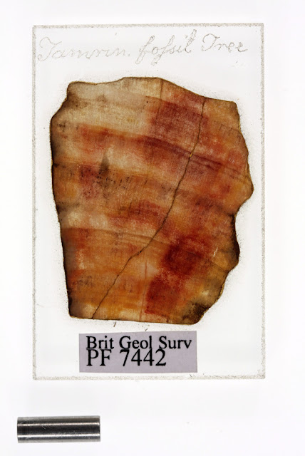
Tampin fossil tree; Microscope slide from the Sir Joseph D. Hooker Collection, BGS.  This slide is of piece of fossil wood from Tasmania collected by Hooker in 1840. The Expedition leader, James Clark Ross recorded that the fossil trees were found encased in ancient lava flows and were preserved as 'most beautiful agate'. Age: Tertiary Period, 40 million years old.
BGS image ID: P776111
Tamrin fossil tree; Microscope slide from the Sir Joseph D. Hooker Collection, BGS.

This slide is of piece of fossil wood from Tasmania collected by Hooker in 1840. The Expedition leader, James Clark Ross recorded that the fossil trees were found encased in ancient lava flows and were preserved as 'most beautiful agate'. Age: Tertiary Period, 40 million years old.

From Collection A: Joseph Dalton Hooker collection. Hooker's collection comprises material collected during his 1839-1843 circum-Antarctic voyage in HMS Erebus and HMS Terror. 

Bob McIntosh

Thursday 25 April 2013

Whitby Harbour, by W.J. Harrison, 1897.

Whitby Harbour, by W.J. Harrison, 1897.
BGS image ID: P243580
Whitby Harbour, by W.J. Harrison, 1897.

The image is from the British Association for the Advancement of Science photograph collection. This collection of over 7,000 photographs is held in the British Geological Survey Archive.

The BAAS collection has had an interesting history. In 1888, O.J. Jeffs proposed to the BAAS that they should address the need for systematic photographic coverage of the geology of the United Kingdom. His proposal was accepted and the BAAS set up a committee under the chairmanship of James Geikie, for the ‘collection, preservation and systematic registration of photographs of geological interest in the United Kingdom’. This was how the collection began.

The collection was first housed in the Geological Survey Museum and Library in Jermyn Street, London and then moved to the new new premises in Exhibition Road. During the Second World War the glass plates were moved 'for safety' to Bristol where unfortunately they were totally destroyed during an air raid, the prints still housed in Exhibition Road remained undamaged.

Bob McIntosh

Wednesday 24 April 2013

Cut and trimmed muscovite mica from the Loch Nevis Mica Prospect, Knoydart, Invernessshire


Muscovite mica from the Loch Nevis Mica Prospect, Knoydart, Invernessshire.  Specimens of graded mica classed as 'Graded No 5 1/2 good stained'. The specimens of muscovite mica would have been worked at the Pitlochry Sorting Factory during the Second World War.
BGS image ID: P527602
Muscovite mica from the Loch Nevis Mica Prospect, Knoydart, Invernessshire.

Specimens of graded mica classed as 'Graded No 5 1/2 good stained'. The specimens of muscovite mica would have been worked at the Pitlochry Sorting Factory during the Second World War. 

After the mica 'books' were extracted from the quarry the first process they underwent was rough dressing. This was initially done near the quarry at Knoydart but soon transferred to the Pitlochry Sorting Factory. It consisted of splitting the books into sheets and the removal by cutting of the flaws, incrustations and striations. The mica would then be passed to the cutters who, using skill and great care would remove the remaining flaws and trim the edges leaving block mica of irregular shape with a curved and indented outline. Further fine splitting to remove stains and spots required great judgement to balance loss in weight with the possibility of improving the quality of the block. The final process was the grading for size and quality. Size was defined by the area of the largest rectangle that could be cut from it, while quality was based on clearness, hardness and flatness. Typical remaining imperfections such as air spots, mineral or vegetable spots or lines, softness or waviness would affect the electrical and/or mechanical properties of the mica. Finally, mica to the weight of around 50 lbs. would be placed into wooden packing cases before despatch to London.

Mica, during wartime, became a mineral of high strategic value, an essential war material which due to its unique physical properties rendered it indispensable as an insulating medium in the manufacture of many types of electrical, radio and telephone equipment.

British Geological Survey Petrology Collection sample number MC 7382.

Bob McIntosh

Tuesday 23 April 2013

George Barrow (1853-1932). Geologist with the Geological Survey of Great Britain.

George Barrow (1853-1932). Geologist with the Geological Survey of Great Britain.
BGS image ID: P575833
George Barrow (1853-1932). Geologist with the Geological Survey of Great Britain. 

Worked at igneous and structural problems in the Eastern Highlands. He was the first to recognize and map zones of progressive metamorphism in the Dalradian of North-East Scotland, the 'Barrovian Zones'. Each zone was identified by the appearance of a set of distinctive index minerals. His work led to the present concept of metamorphic grade. 

Later in his career he became the District Geologist for London with a particular interest in water-supply and in the construction and maintenance of railways.

Another picture when he was in Scotland: The Bandits Lair.

Bob McIntosh

Monday 22 April 2013

Lost Johns' Cave, Leck Fell. Leeds Cave Club meet Easter 1932.

Lost Johns' Cave, Leck Fell. Leeds Cave Club meet Easter 1932. A meal at 3am, 3rd April in Candle Pot, nearly 400 feet from the surface. (Cliff Wilkinson, Flemming and Brench).
BGS image ID: P617282
Lost Johns' Cave, Leck Fell. Leeds Cave Club meet Easter 1932. A meal at 3am, 3rd April in Candle Pot, nearly 400 feet from the surface. (Cliff Wilkinson, Flemming and Brench).

Photograph from the H.W. Haywood Collection. Two albums of photographs showing the Leeds Cave Club meets.

Bob McIntosh

Sunday 21 April 2013

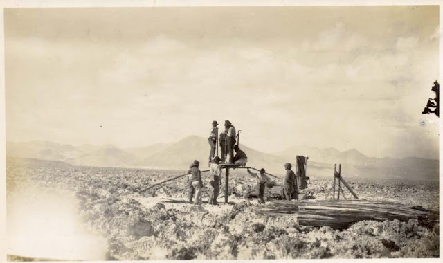
Commencing work with the 'Empire' drill. Chile. From the W.J. Reynolds Collection. c. 1922.

Commencing work with the 'Empire' drill. Unknown location, Chile. From the W.J. Reynolds Collection. c. 1922.
BGS image ID: P608816
Commencing work with the 'Empire' drill. Unknown location (possibly Atacama), Chile. From the W.J. Reynolds Collection. c. 1922.

The W.J. Reynold Collection is a small album of photographs from Chile, Romania, California, West Africa and South Africa.

Bob McIntosh

Saturday 20 April 2013

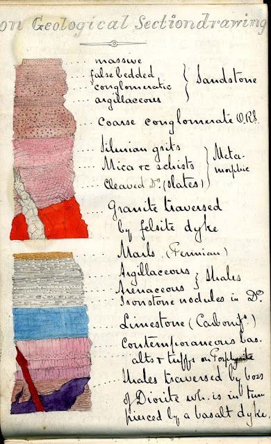
On geological section drawing - a page from a field notebook, Henry Mowbray Cadell

On geological section drawing - a page from a field notebook, Henry Mowbray Cadell
BGS image ID: P680480

On geological section drawing - a page from a field notebook by Henry Mowbray Cadell, (1860-1934).

Cadell was a geologist with the Geological Survey of Great Britain.

Bob McIntosh

Friday 19 April 2013

River transport by traditional 'dugout' canoe. Gold Coast. 1919. E.O. Teale photograph collection.

River transport by traditional 'dugout' canoe. Gold Coast. 1919. E.O. Teale photograph collection.
BGS image ID: P776549
River transport by traditional 'dugout' canoe. Gold Coast. 1919. E.O. Teale photograph collection.

Bob McIntosh

Thursday 18 April 2013

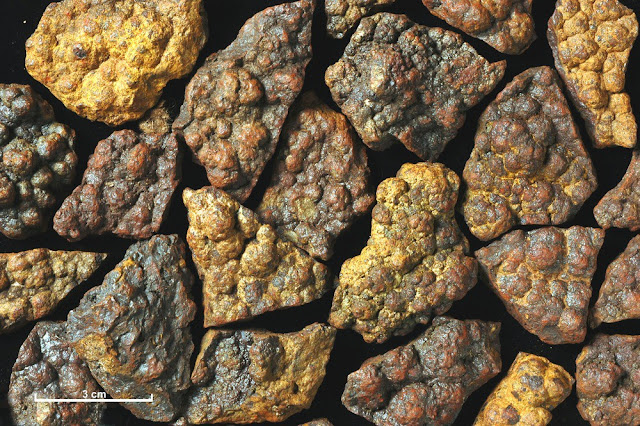
Iron ore from a vein at the east end of Loch Monar, Ross and Cromarty


A collection of specimens of iron ore from a vein at the east end of Loch Monar, Ross and Cromarty, showing a distinctive botryoidal form.
BGS image ID: P527598
A collection of specimens of iron ore from a vein at the east end of Loch Monar, Ross and Cromarty, showing a distinctive botryoidal form. Iron making has had a long history in Scotland. Firstly bog iron ores were used in the early bloomeries and later, haematite and clayband ironstones were used, the former probably imported. Iron ores such as this specimen were fairly rare in Scotland, perhaps the most well known locality is the Leicht Mine at Tomintoul. Iron ores come in many types from bog iron ores, haematite ores, clayband and blackband Carboniferous ores and the much younger Jurassic ores such as those from Raasay.

British Geological Survey Petrology Collection sample number MC 7378. 

Bob McIntosh

Wednesday 17 April 2013

Der Aetna und die von ihm ergossenen Laven-Stroeme, Carl E. von Leonhard, 1844

Der Aetna und die von ihm ergossenen Laven-Stroeme. Leonhard, Carl  E.: Vulkanen-Atlas zur Naturgeschichte der Erde Stuttgart 1844

Der Aetna und die von ihm ergossenen Laven-Stroeme. Leonhard, Carl  E.: Vulkanen-Atlas zur Naturgeschichte der Erde Stuttgart 1844.

An early map of Mount Etna.

Bob McIntosh

Tuesday 16 April 2013

H.M.Cadell's famous mountain building experiments

H.M.Cadell's famous mountain building experiments. Photo of his experimental ‘squeeze box’ at The Grange, Bo’ness 25th January 1887. Cadell was a mining consultant and industrialist and for some time was a member of staff of the Geological Survey in Scotland.
 BGS image ID  P612832
H.M.Cadell's famous mountain building experiments. Photo of his experimental ‘squeeze box’ at The Grange, Bo’ness 25th January 1887. Cadell was a mining consultant and industrialist and for some time was a member of staff of the Geological Survey in Scotland.

Using wet sand and plaster of Paris he tried to recreate thrust geometries seen in the North-west Highlands.

Bob McIntosh

Monday 15 April 2013

Geologists' Association Field trip - Oswestry 1908 - group photograph


Geologists' Association  - Oswestry  Excursion, 1908 - group photograph. Photograph from the GA 'Carreck Archive'


Geologists' Association  - Oswestry  Excursion, 1908 - index to people in the group photograph. Photograph from the GA 'Carreck Archive'

Geologists' Association  - Oswestry  Excursion, 1908 - group photograph. Photograph from the GA 'Carreck Archive'

Bob McIntosh

Sunday 14 April 2013

Granite dressing sheds at De Lank quarries, St. Breward, Cornwall


Granite dressing sheds at De Lank quarries, St. Breward, Cornwall. Looking west-north-west. The De Lank quarries work the coarse-grained, grey granites of Bodmin Moor.
BGS image ID: P000510

Granite dressing sheds at De Lank quarries, St. Breward, Cornwall. Looking west-north-west.
The De Lank quarries work the coarse-grained, grey granites of Bodmin Moor. The extensive range of granite products on display in the De Lank dressing sheds is a tribute to the skills of the masons who originally worked this hard intractable stone with only limited hand tools. Since the 15th century granite has been used in buildings as hewn blocks and cut into ashlar. Also, up to about 1800, granite was taken from the vast amounts of surface debris. More recently there was demand for building blocks of ground 'reconstituted' granite where planning regulations demanded the use of stone. The De Lank Quarries near Bodmin produced a light grey granite. Large blocks were obtained from the quarries because of the regular jointing. The Eddystone, Beachy Head and Small Rock lighthouses are among many buildings constructed from De Lank granite.

Old BGS photograph number A00517

Date of image: 1907

Bob McIntosh

Saturday 13 April 2013

Drilling the Archerbeck Borehole, Canonbie, Dumfriesshire.


BGS image ID: P001457
Archerbeck Borehole, Canonbie, Dumfriesshire.  Drilling at Archerbeck was part of the Geological Survey of Great Britain exploratory boring programme. It commenced in 1954 and was completed in 1955.

Each length of drilling pipe is raised by the hoisting system consisting of the crown block and travelling block. When the joint appears the drillstring is wedged in place in the drilling floor by using slips (so it is not lost down the hole) then the two sections of pipe are unscrewed. The drawworks can be seen behind the drilling pipe. It is the winch that raises the travelling block through the crown block. Unscrewing and stacking drilling rods while pulling out. This process is required when changing the drilling bit or when taking a solid core. The latter is very time consuming and therefore costly as the full drillstring needs to be retrieved for each length of core.

Date taken: 1955
BGS old photograph number:  C04247


Archerbeck Borehole, Canonbie, Dumfriesshire. A length of core just removed from the core barrel, boxed and marked ready for transport to the core-shed.  A length of core just removed from the core barrel, boxed and marked ready for transport to the core-shed. Note how the core comes out in sections, this is typical. The 'way up' of the core is marked on each piece. The reamer can be seen to the right of the driller on the left.
BGS image ID: P001460
A length of core just removed from the core barrel, boxed and marked ready for transport to the core-shed. Note how the core comes out in sections, this is typical. The 'way up' of the core is marked on each piece. The reamer can be seen to the right of the driller on the left.

Date taken: 1955
BGS old photograph number:  C04250

A major scientific borehole is currently being drilled NOW in the Scottish Borders. The project is called TWeed - Tetrapod World: early Evolution. It is a collaboration led by the University of Cambridge with members from BGS, National Museums Scotland, University of Southampton and University of Leicester. The aim of TWeed is to discover the missing links in how modern species evolved from 359 million year old limbed vertebrates, the tetrapods, the so called 'Romer's Gap' in the fossil record.

Updates on the drilling can be found on the TetrapodWorld blog.

Bob McIntosh

Friday 12 April 2013

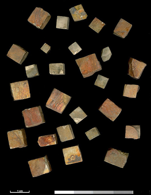
Mineral specimen of pyrite. Cuan Slate Quarry, Luing, Argyllshire

Mineral specimen of pyrite. Cuan Slate Quarry, Luing, Argyllshire.  The image shows a number of near-perfect cubic crystals of pyrite. They have a variable colour and are stained with yellow and orange colours due to the presence of secondary iron oxide minerals on the crystal surfaces. When fresh pyrite has a metallic brass-yellow colour.
BGS image ID: P521549
Mineral specimen of pyrite. Cuan Slate Quarry, Argyllshire.

The image shows a number of near-perfect cubic crystals of pyrite. They have a variable colour and are stained with yellow and orange colours due to the presence of secondary iron oxide minerals on the crystal surfaces. When fresh pyrite has a metallic brass-yellow colour. 

Crystals of pyrite such of this are common in the slate deposits of the Easdale area. They were referred to as 'diamonds' by the quarrymen, although economically they are practically worthless. Pyrite is an iron sulphide mineral belonging to the cubic crystal system that occurs as striated, cubic, octahedral or pyritohedral crystals. These specimens come from a small quarry in the 25-ft raised-beach platform 150 yards from the quay at Cuan Ferry at the north end of Luing. The thicker seam contains a bluish-grey slate with fairly large pyrites crystals, although the crystals usually cleave through, and do not pull out when the slate is split. The other seam lies immediately west of the thicker seam. It is a darker slate and rather softer in quality, with very small pyrites crystals. The slate and pyrites belong to the Dalradian Supergroup (Precambrian) Easdale Slate, predominantly black carbonaceous pyritic slates.

Bob McIntosh

Thursday 11 April 2013

Geological map of Alderney

Geological map of Alderney
BGS image ID: P818145
This geological map of Alderney was made by German geologist Wather Klüpfel during the German occupation of the Channel Islands. Klüpfel (1888-1964) was stationed in the Channel Islands between 1941 and 1944 and carried out work relating to water supply, building material, mineral resources and geological structure.

Part of the Casimir/Klüpfel collection at BGS Archives

Andrew L Morrison

Stoop and room, Middleton Quarry and Mine, Gorebridge. Midlothian.

Middleton Quarry and Mine, Gorebridge. Midlothian. Stoop and room (pillar and stall) is an old method of mining where the material, in this case limestone is extracted leaving pillars of limestone in place to support the roof.
BGS image ID: P000178
Middleton Quarry and Mine, Gorebridge. Midlothian.

Stoop and room (pillar and stall) is an old method of mining where the material, in this case limestone is extracted leaving pillars of limestone in place to support the roof.

Interior view of the mine illustrating the method of extraction. A figure in the centre of the image illustrates the scale. Mining the North Greens (No. 2) Limestone. The thickness of the seam is 50 ft. though only the lower 20 ft. is in massive beds and suitable for mining. Chemical analysis shows it is 94.09% calcium carbonate and is of uniform high quality. The limestone was burnt in vertical, continuous mixed-feed kilns to produce lime for both agriculture and building purposes. Ground limestone was also produced. The rocks are of the Lower Limestone Group of the Carboniferous period. The quarry is now disused.

Date of image: 1945.

Bob McIntosh

Wednesday 10 April 2013

Sir Roderick Murchison's medals


Sir Roderick Murchison's Medals
BGS image ID: P582068
These medals were awarded to Sir Roderick Murchison (1792-1871). Having served in the army during the Napoleonic wars he later became intersted in geology. He was elected President of the Geological Society in 1831 and succeeded Henry De la Beche as Director of the Geological Survey in 1855.

The medals include the St Ann Cross, Russia; The Dannebrog, Denmark; St Ann Star, Russia; The Crown, Italy; St Stanislaus Cross, Russia; Pennisula Medal; Order of the Bath, UK; St Stanislaus Star, Russia; The Rose, Brasil and The Polar Star, Sweden.

Andrew L Morrison
Travelling in style, at Newlands Corner, Geologists' Association Motor excursion in Surrey, June 6th 1914

Geologists' Association Motor excursion in Surrey, June 6th 1914. At Newlands Corner.
BGS image ID: P804705
Geologists' Association Motor excursion in Surrey, June 6th 1914. At Newlands Corner.

From the Geologists' Association 'Carreck Archive'

Does anyone know the make of coach?

Bob McIntosh

Tuesday 9 April 2013

Mica processing at the Pitlochry Depot, Perthshire. 1945.


Processing of Scottish mica. Pitlochry Depot (January 1945). Perthshire. Cutting and trimming mica at the Sorting Factory.
BGS image ID: P000163
Processing of Scottish mica. Pitlochry Depot (January 1945). Perthshire. Cutting and trimming mica at the Sorting Factory.

The split mica sheets are trimmed of all flaws, structural imperfections or, less serious, inclusions. The cutting knife is held at a low angle to the cleavage so the plates are consequently bevelled. The workers can clearly be seen using their knives. Processing of mica involved three stages, 1. rough cobbing, 2. splitting, 3. trimming. It does not undergo any other process of treatment or concentration before it is ready for use.


Processing of Scottish mica. Pitlochry Depot (January 1945). Perthshire. Plates of mica illustrating the various commercial grades.
BGS image ID: P000185
Plates of mica illustrating the various commercial grades. 

The photograph shows eight grades of mica. One to four are grades of staining. Five to seven are grades of spotting. Eight is a mica showing zoning, a structural imperfection. Note the re-entrant angles on three and four where imperfections have been cut out. Mica is graded for commercial purposes according to type, colour and freedom from staining. The primary division is into Muscovite or White Mica and Phlogopite or Amber Mica. Muscovite is subdivided into two types 'Ruby' and 'Green' types. Both are colourless when less than 0.5 mm. but when greater than this size they have reddish and greenish tinges respectively.

Production from the Pitlochry factory totalled 7,122 lbs. of block mica in addition 85 tons of scrap mica, resulting from the dressing operations, was sold. Mica, during wartime, became a mineral of high strategic value, an essential war material which due to its unique physical properties rendered it indispensable as an insulating medium in the manufacture of many types of electrical, radio and telephone equipment.

Bob McIntosh

Monday 8 April 2013

Diatomite from the Muir of Dinnet, Ballater, Aberdeenshire.


A collection of specimens of diatomite from the deposit at Muir of Dinnet near Ballater, Aberdeenshire.
BGS image ID: P527720
A collection of specimens of diatomite from the deposit at Muir of Dinnet near Ballater, Aberdeenshire. 

Diatomite is a whitish, fine-grained substance consisting essentially of siliceous skeletons or frustrules of diatoms, minute organisms. British Geological Survey Petrology Collection sample number MC 7497. 

Most diatomite is laid down in freshwater lakes and swamps. This deposit was first recognized as diatomaceous by the Rev. George Davidson in about 1880. An analysis by Mr. Ivison Macadam showed that the inorganic portion contained 82.96 per cent silica, 5.5 per cent iron oxide, 2.1 per cent alumina and 2.93 magnesia. It compared with the specimens of German kieselguhr for purity. 

The deposit was explored by sinking shafts and it was estimated that the deposit contained 800,000 cubic yards of kieselguhr, 6 cubic yards of which, when fully dried would make a ton. The diatomite occurred at a number of localities: Black Moss, 162 acres in area, 15 feet to a few inches thick and 800,000 cubic yards; Ordie Moss, originally 8 acres but now worked out; Loch Kinnord; Haugh of Milton 10-12 acres, one foot thick 17,700 cubic yards; Auchnarran, 46 acres, 15 inches thick 92,700 cubic yards.

Almost all the diatomite went to the Ardeer explosive works in Ayrshire where it was used as a carrier or absorbent for nitroglycerine in dynamite manufacture. (Good diatomite will absorb four times its weight in water.)


Bob McIntosh

Sunday 7 April 2013

Descending a denehole at Hangman's Wood, West Thurrock, Essex.

Descending a Denehole at Hangman's Wood at West Thurrock, Essex. 1908. From the GA 'Carreck Archive'
BGS Image ID: P805290

Descending a Denehole at Hangman's Wood at West Thurrock, Essex. 1908. From the GA 'Carreck Archive'

'In the course of ploughing this field the horse's feet broke through the surface. We procured a rope and the pole of a waggon and investigated the interior. The shaft descended through about 12 feet of Thanet Sand and entered into a beehive-shaped chamber about 20 ft. high. These deneholes were formed in getting the chalk in past ages for marling the land.'

Deneholes are typically about 60 feet deep with steps cut into the side of the shaft to allow climbing in and out. At the bottom they open out to a domed chamber, often with sub-chambers.

It is though that chalk was mined this way from pre-Roman times.

Photographer: T.W. Reader

Bob McIntosh

Saturday 6 April 2013

Geologists' Association Excursion to Derbyshire, August 3rd 1914. Bonsall.

Group photograph, Geologists' Association Excursion to Derbyshire, August 3rd 1914. Bonsall.
BGS Image ID: P804358
Group photograph, Geologists' Association Excursion to Derbyshire, August 3rd 1914. Bonsall.

From the Geologists' Association 'Carreck Archive' currently being digitized at the British Geological Survey.

Bonsall is an old mining town. Lead was mined there and in nearby Wirksworth from Roman times. The market cross is medieval and is the tallest market cross in Derbyshire. John Wesley, founder of the Methodist movement preached from the top step. The King's Head public house on the far right dates back to 1677.

Bob McIntosh

Friday 5 April 2013

Hantergantick Quarry, Cornwall. Thermal lance demonstration.

Hantergantick Quarry, Cornwall. Thermal lance demonstration.
BGS image ID: P539881
Hantergantick Quarry. Jet cutting demonstration using a thermal lance to cut granite with heat and sound energy. Early 1960s. Note gas cylinders in the background. Hugh O'Neill Collection.

The temperature is believed to reach 3000 degrees C.

Bob McIntosh

Thursday 4 April 2013

Geological Survey of England and Wales 1:63,360 geological map series [Old Series] Sheet 34 - map extract


Extract of the Swindon area from the Geological Survey of England and Wales 1:63,360 geological map series [Old Series] Sheet 34 [Stroud, Cirencester, Fairford, Swindon, Chippenham, Marlborough Downs.] Decr. 1857. A beautifully hand-coloured map painted with watercolours.

The map is one example from c. 2,200 maps and sections dating from 1832 and released yesterday on the British Geological Survey OpenGeoscience service.

Bob McIntosh

Wednesday 3 April 2013

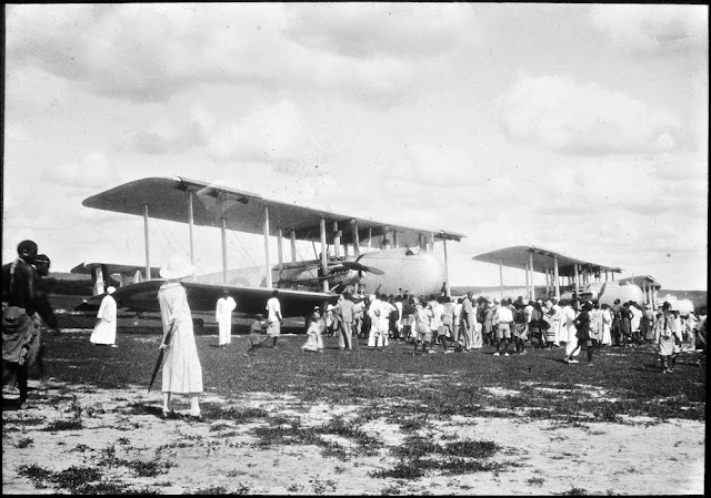
Three Vickers Victoria aircraft unloading cargo. Royal Air Force at Dodoma, 1929.


Royal Air Force at Dodoma. Three Vickers Victoria aircraft unloading cargo, 1929. E.O. Teale photograph collection.
BGS image ID: P776210
Royal Air Force at Dodoma. Three Vickers Victoria aircraft unloading cargo, 1929. E.O. Teale photograph collection.

Bob McIntosh

Tuesday 2 April 2013

The Grizzly Bears - the dining club of the geologists of the Geological Survey of Scotland. 1869.


The Grizzly Bears - the dining club of the geologists of the Geological Survey of Scotland. 1869.

The Grizzly Bears - the dining club of the geologists of the Geological Survey of Scotland. Their first meeting was in Dejay's Hotel in Edinburgh on February 16th 1869 and they continued up to 1970. The records of the dinners are held in the three volume 'Dinner Books', an amazing informal record of the songs, recitations, sketches and other ephemera relating to activities at the dinners. The usually humorous songs and recitations were written by the geologists themselves and they relate to geology, their work, and life in the Geological Survey.

Dining clubs were common in late-Victorian Britain. A dining club based in London for the England and Wales staff of the Survey was called 'The Royal Hammerers'. 

Note the Grizzly Bear at the head of the table - he is holding a geological hammer - no doubt to call order!

Bob McIntosh

Monday 1 April 2013

The Rock and Spindle, 3.621 km. east of St. Andrews. Fife Region.

The 'Rock and Spindle', 3.621 km. east of St. Andrews. Fife Region
BGS image ID: P000250
The 'Rock and Spindle', 3.621 km. east of St. Andrews. Fife Region. The prominent low stack in the vicinity of the Kinkell Ness Vent is a volcanic 'neck' within the Carboniferous Calciferous Sandstone Series. The radiating spokes of the 'Spindle' are columnar jointed basanite (basalt) and are relatively free from xenoliths while the rest of the stack into which the spindle grades without any sign of contact is basalt containing many xenoliths, igneous towards the centre and masses of sedimentary rocks, sandstones and limestones up to two metres across around the outside.

BGS old photograph number: B474. Whole Plate.
Photographer: R. Lunn
Date of photograph: 1895

Bob McIntosh