Thursday 10 December 2015

1912 British Association Field Excursion to Inchnadamph - signatures

Signed copy of the North-West Higlands Memoir
Signatures in the North-West Highlands Memoir

During recent stocktaking at Murchison House, British Geological Survey in Edinburgh, a copy of the North-west Highlands Memoir (Peach et al, 1907) was found in the Palaeontological Department. It has been rebound but is in excellent condition with little signs of use and no obvious foxing. The memoir contains detailed descriptions of the Lewisian, Torridonian, Moine and Cambrian-Ordovician rocks in the Durness to Kyle of Lochalsh area, summarising the results of the survey’s detailed work there in the late 19th century. This copy patently belonged to John Horne who was Assistant Director in the Geological Survey in Scotland from 1901 until his retirement in 1911.

The fly leaf of the memoir contains the signatures of 29 attendees of the renowned 1912 excursion to Assynt, which followed on from a British Association meeting in Dundee in mid-September that year. This excursion, led by Peach and Horne, was attended by 31notable European and British geologists (see Barber, 2010). The flyleaf also contains the signatures relating to an excursion undertaken in 1914, when John Horne took a further party to Assynt. Attendees included Sir Alexander and Lady (Rachel Workman) MacRobert, but also included the well-known geologists Reginald A Daly and Professor Molengraaf. Rachel Workman, the daughter of the noted American mountaineers William and Fanny Workman, was educated at Cheltenham Ladies College and gained a degree in geology from the University of London in 1902. She undertook research and published papers on alkaline igneous rocks (e.g. carbonatite and nepheline syenite) and was one of the first women to be elected a fellow of the Geological Society in 1919. Information on the MacRobert Trust, including her ladyship’s contribution to the Second World War, can be found at The MacRobert Trust. The memoir is to be archived by BGS.

Peach, B.N., Horne, J., Gunn, W., Clough, C.T., Hinxman, L.W. & Teall, J.J.H. (1907).  The geological structure of the northwest Highlands of Scotland.  Memoirs of the Geological Survey, U.K. 

Barber, A. J. 2010. Peach and Horne: the British Association excursion to Assynt September 1912. In Law, R.D., Butler, R.W.H., Holdsworth, R.E., Krabbendam, M. and Strachan, R.A. (editors) Continental Tectonics and Mountain Building: The Legacy of Peach and Horne. Geological Society, London, Special Publications, 335, 29-49.

Dr. John Mendum

Photograph of the entire party of the Assynt Excursion led by B.N. Peach and J. Horne, taken outside the Inchnadamph Hotel during September 1912. Excursion of the British Association for the Advancement of Science Meeting held in Dundee.

Photograph of the foreign visitors outside the Inchnadamph Hotel, Assynt Excursion held in September 1912, led by B.N. Peach and J. Horne. Excursion of the British Association for the Advancement of Science Meeting held in Dundee.

The 1914 Excursion. Photograph outside the Inchnadamph Hotel


Title page of the famous North-West Highlands Memoir
Title page of the famous North-west Highlands Memoir

Posted by Dr. John Mendum

Sunday 22 November 2015

CALX carbonata (calcite) from British mineralogy by James Sowerby 1802-1817

  CALX carbonata; var. inversa. Inverse crystallized Carbonate of Lime. Plate no. 143
BGS Image ID: P704769


  CALX carbonata; var. inversa. Inverse crystallized Carbonate of Lime. Plate no. 143

From: Sowerby, James. 1802-1817. British Mineralogy: Or Coloured figures intended to elucidate the mineralogy of Great Britain. Plate from vol: 2. page no.81.

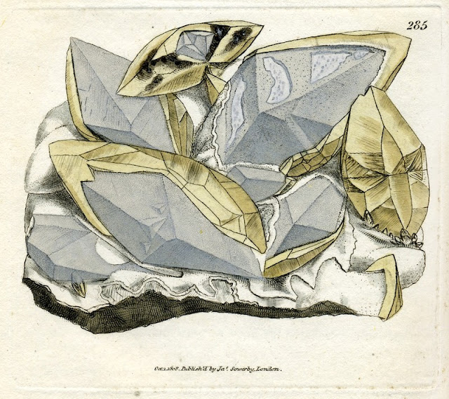
CALX carbonata. Crystallised Carbonate of Lime. Plate no. 285
BGS Image ID: P704911
CALX carbonata. Crystallised Carbonate of Lime. Plate no. 285

From: Sowerby, James. 1802-1817. British Mineralogy: Or Coloured figures intended to elucidate the mineralogy of Great Britain. Plate from vol: 3. page no.171. Modern name: Calcite. Location: Samples from the Dimple mine near Matlock.


CALX carbonata, var. metastatica. Metastatic crystallised Carbonate of Lime. Plate no. 314
BGS Image ID: P704940
CALX carbonata, var. metastatica. Metastatic crystallised Carbonate of Lime. Plate no. 314

From: Sowerby, James. 1802-1817. British Mineralogy: Or Coloured figures intended to elucidate the mineralogy of Great Britain. Plate from vol: 4. page no.19. Modern name: Calcite. Location: Sample collected in Derbyshire.

Friday 23 October 2015

William Edmond Logan - A Geological Pioneer


A geologist with the then Ordnance Geological Survey (now the British Geological Survey) from its inception in 1835 and a contemporary of Henry de la BecheWilliam Edmond Logan went on the become the first Director of the Geological Survey of Canada which was formed in 1842. He remained in that post until 1869 when he was succeeded by another pioneer of the British Geological Survey, Alfred Richard Cecil Selwyn
 

William Edmond Logan (20 April 1798 - 22 June 1875)


Alfred Richard Cecil Selwyn
(20 July 1824 - 19 October 1902)
Henry Thomas De la Beche 
(10 February 1796 - 13 April 1855) 


From the British Geological Survey Library in Edinburgh, the following images show a couple of early examples of the Exploration Geologique du Canada: Rapport de Progrès or the Geological Survey of Canada: Report of Progress, the first published in 1846 with the progress from the year 1844. 


Exploration Geologique du Canada: Rapport de Progrès 


In a paper presented to the 'History of the Book in Canada’ Open Conference in May 2001: 
‘I wish these annual reports were at the devil’: William E. Logan and the publications of the Geological Survey of Canada,  Brian Shipley discusses the process undertaken by Logan in producing these Reports of Progress, revealing the objections Logan had in this approach to documenting the work of the Survey. 

Shipley's thesis; 'From Field to Fact: William E. Logan and the Geological Survey of Canada' is also available to download from Dalhousie University Library. 

A notable and honoured man, Logan is the subject of a Dinner Address made by J.M. Harrison at the Annual Dinner of the Geological Association of Canada on the 7th June 1963, which makes for an entertaining and informative read. 

Harrison, J.M. and Hall, E. (1963) Dinner Address: "William Edmond Logan". Proceedings of the Geological Association of Canada. Vol 15.  
                 
There are many routes for further exploration of the life and work of this celebrated Geologist, Written in Stone : William E. Logan and the Geological Survey of Canada is just one of them.


Posted by : Emma Illingworth

Tuesday 13 October 2015

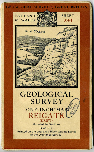
Geological Survey of England and Wales 1:63,360 maps - map covers

Cover for sheet 286 Reigate (Drift ) 1:63,360 map. 1938.  Thi illustration on the cover is common to all sheets published at the time. Does anyone know if the place depicted is a real place?

Cover for the folded sheet 286 Reigate (Drift) 1:63,360 map. 1938.

The illustration on the cover is common to all sheets issued 'mounted in sections' at that time. Does anyone know if the place depicted is a real place and if so, where it is?


Panel from sheet 286 Reigate (Drift ) 1:63,360 map. 1938.

Panel from sheet 286 Reigate (Drift ) 1:63,360 map. 1938. The full map can be viewed in the BGS Maps Portal.

Cover for 1:63,360 Special sheet Arran. Published 1910
Cover for 1:63,360 Special sheet Arran. Published 1910.The full map can be viewed in the BGS Maps Portal.

Posted by Bob McIntosh

Thursday 17 September 2015

Carte géologique du terrain entre le lac d'Orta et celui de Lugano. Leopold von Buch. [1829]

Extract from the map

Geological cross-section

Section of the key

Carte géologique du terrain entre le lac d'Orta et celui de Lugano. Leopold Buch. [1829].

An image of the full map can be found here

Christian Leopold von Buch (1774 – 1853) was a German geologist and paleontologist. He was the first Foreign Member of the Geological Society of London.

A biography of  Christian Leopold von Buch

Posted by Bob McIntosh

Tuesday 8 September 2015

Eruptive rocks of Brent Tor by Frank Rutley, 1878.

 Plate VIII.  Basalt with glassy magma mainly devitrified. Brent Tor, North-west side of the foot of the Tor, Magnification x55.

Plate VIII. 
Basalt with glassy magma mainly devitrified. Brent Tor, North-west side of the foot of the Tor, Magnification x55.

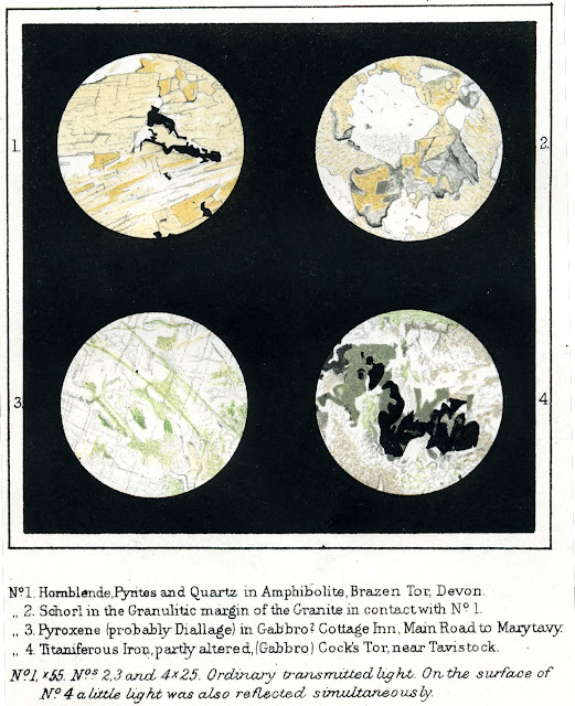
The 'Eruptive rocks of Brent Tor and its neigbourhood' was the first special petrographical work issued by the Geological Survey. It is dated 1878.  It denotes a time when microscopic examination of rocks collected during the mapping of new districts became routine. Colour chromolithographs.

Frank Rutley was also the author of Elements of Mineralogy first published in 1874 and still available in print today in its 27th edition!

Plate IX. 1. Decomposed Greenstone, Greston Bridge. 2. Slate beneath lower Greenstone, Greston Bridge. 3. Elvan, S. end of Shilla Mill Quarry (Polarized). 4.Mag'n. Mica and cavities in Quartz of Granite, Brazen Tor. 5. Fluid cavities containing cubes of NaCl, Brazen Tor. 6. Amygdaloidal Schalstein, Churlhanger, near Lamerton.
Plate IX.
1. Decomposed Greenstone, Greston Bridge.
2. Slate beneath lower Greenstone, Greston Bridge.
3. Elvan, S. end of Shilla Mill Quarry (Polarized).
4.Mag'n. Mica and cavities in Quartz of Granite, Brazen Tor.
5. Fluid cavities containing cubes of NaCl, Brazen Tor.
6. Amygdaloidal Schalstein, Churlhanger, near Lamerton.

Plate X No. 1 Hornblende, Pyrites and Quartz in Amphibolite, Brazen Tor, Devon No 2 Schorl in the Granulitic margin of the Granite in contact with No. 1 No 3. Pyroxene (probably Diallage) in Gabbro? Cottage Inn, Main Road to Marytavy. No. 4 Titaniferous Iron, partly altered (Gabbro) Cock's Tor, near Tavistock. Bo. 1 x55. Nos. 2,3 and 4 x25. ordinary transmitted light. On the surface of No. 4 a little light was also reflected simultaneously.


Plate X
No. 1 Hornblende, Pyrites and Quartz in Amphibolite, Brazen Tor, Devon
No 2 Schorl in the Granulitic margin of the Granite in contact with No. 1
No 3. Pyroxene (probably Diallage) in Gabbro? Cottage Inn, Main Road to Marytavy.
No. 4 Titaniferous Iron, partly altered (Gabbro) Cock's Tor, near Tavistock.
Bo. 1 x55. Nos. 2,3 and 4 x25. ordinary transmitted light. On the surface of No. 4 a little light was also reflected simultaneously.

Brent Tor. (South side near the base) x25 Brent Tor. (North side) x25
Brent Tor. (South side near the base) x25
Brent Tor. (North side) x25

A selection of plates from the memoir:

Brent Tor from Hart's Hall, near Morwellham

Brent Tor from Hart's Hall, near Morwellham
Great Staple Tor on the western Margin of Dartmoor (mural jointing in granite).

 Great Staple Tor on the western Margin of Dartmoor (mural jointing in granite).

The Master Rock, Horndon.

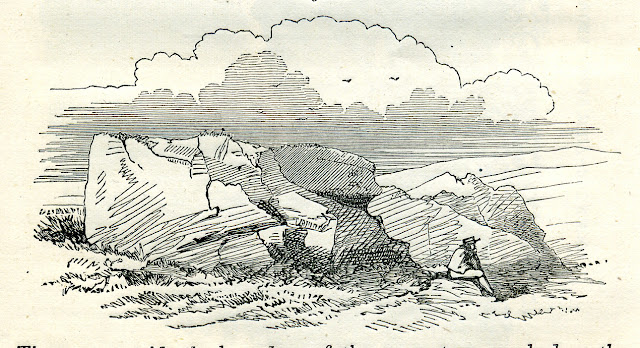
The Master Rock, Horndon. (woodcut)

Posted by Bob McIntosh


Sunday 30 August 2015

Sunken lanes in southern England

Sunken lane, road from Thorncombe Street leading to Godalming via Munstead Heath, Surrey. Looking north-west at the road from Thorncombe Street (2 m. south-east of Godalming) leading to Godalming via Munstead Heath. A sunken lane in Hythe Beds.
BGS Image ID: P209857

Sunken lane, road from Thorncombe Street leading to Godalming via Munstead Heath, Surrey. Looking north-west at the road from Thorncombe Street (2 m. south-east of Godalming) leading to Godalming via Munstead Heath. A sunken lane in Hythe Beds. A section in 15 to 20 ft. of evenly-bedded loamy sand, containing seams of siliceous sandstone up to 3 inches thick. This road-cutting results from the wear caused by wheeled and hoofed transport over the years (before the road was metalled) and the removal of the sandy debris by rainwash and wind etc. on this sloping ground, which lies below the plateau formed by the Bargate Beds at the top of the hill beyond the car. The sunken roads of the Weald are a good example of man as a geological agent. Roads and farm tracks of this type are common over the whole of the Lower Greensand outcrop and in some localities on the outcrops of the Lower Tunbridge Wells Sand the Upper Greensand and the Chalk. All stages of their formation can be seen from simple tracks to cuttings 20 feet deep.


Sunken lane, South Ambersham. Deep sunken lane in Selham Ironshot Sands. These coarse-grained limonite-rich sands are a local development within the Lower Greensand.
BGS Image ID: P212403

Sunken lane, South Ambersham. Deep sunken lane in Selham Ironshot Sands. These coarse-grained limonite-rich sands are a local development within the Lower Greensand.


Sunken lane approximately 850 m. SSE of Tillington Church. Sunken lane in Lower Greensand sandstones.
BGS ImageID: P212907

Lane to the S. of Wotton hamlet. Sunken lane in Hythe Beds near Wotton.

Sunken lane approximately 850 m. SSE of Tillington Church. Sunken lane in Lower Greensand sandstones. Pale fawn silty sandstones in Lower Greensand exposed in west side of lane. Fine-grained sands with nodular chert horizons are present.
BGS ImageID: P212404

Sunken lane approximately 850 m. SSE of Tillington Church. Sunken lane in Lower Greensand sandstones. Pale fawn silty sandstones in Lower Greensand exposed in west side of lane. Fine-grained sands with nodular chert horizons are present.

Posted by: Bob McIntosh

Monday 17 August 2015

Landslip at Holbeck Hall Hotel, Scarborough 1993

The Holbeck landslide, south of Scarborough in North Yorkshire
BGS Image ID:P509016

The recent landslip at Mappleton demonstrates what an active coast Yorkshire has. The pictures from the archive today shows a landslide that happened in June 1993 further up the coast from Mappleton and just south of Scarborough.

The Holbeck landslide, south of Scarborough in North Yorkshire, attracted considerable interest when it destroyed the four-star Holbeck Hall Hotel between the night of 3 June and 5 June 1993. A rotational landslide involving about 1 million tonnes of glacial till cut back the 60 m high cliff by 70 m. It flowed across the beach to form a semicircular promontory 200 m wide projecting 135 m outward from the foot of the cliff. 

The likely cause of the landslide was a combination of: rainfall of 140 mm in the two months before the slide took place; issues related to the drainage of the slope; pore water pressure build up in the slope and the geology. 

The first signs of movement on the cliff were seen six weeks before the main failure, when cracks developed in the tarmac surface of footpaths running across the cliffs. These were filled to stop ingress of water to the cliff, but when the cracks reopened, shortly before the main failure, the council closed the cliff paths below the hotel. At this time a small part of the hotel garden was also observed to have suffered a minor movement.

There was originally 70 m of garden between the hotel and the cliff edge. At 6 am on the 4 June a guest saw that 55 m of the garden had disappeared. The hotel was evacuated and the landslide continued to develop, culminating in the collapse of the east wing of the hotel by the evening of 5 June.

The landslide is a rotational landslide degrading to a mud/debris flow which covered the rocks on the beach (platform).

The cliff consists of Glacial Till (sandy, silty clay) resting on a low cliff of the Middle Jurassic Scalby Formation. The Scalby Formation comprises Scalby Mudstone and Moor Grit (sandstone).

BGS Image ID:  P707131
Post by Bob McIntosh

Saturday 1 August 2015

Camborne mining district, Cornwall. 1904

BGS image ID: P200035

View of the Camborne mining district taken from the engine house of Dolcoath Mine. Looking E. In the distance, to the right, can be seen Carn Brea. 1904.

Photo by T.C. Hall

Posted by Bob McIntosh

Sunday 26 July 2015

Brora coal pit, Sutherland, 1899


Brora coal-pit, 0.8 km. west of Brora. Sutherland. Coal-pit and rock exposures (lower part of the Jurassic Corallian and Oxford Clay). The photograph shows the small colliery workings with a row of cottages to the right. The main seam of the Brora Coal was c. 3 feet 6 inches thick within which was a band of pyrites. This greatly reduced its value. Most coal in Scotland is derived from Carboniferous strata, the Brora Coal is unusual in that it is of much younger Jurassic age. The coal had a strong sulphurous odour, was liable to spontaneous combustion both in the mine and on the spoil heaps or even in transit and it had a high ash content. The history of mining of this coal dates back to 1598 when Jane, Countess of Sutherland opened the first pit. Many other records of mining exist since then. In 1910 output was 6000 tons. The coal raised was used in the immediate neigbourhood, at the brickworks adjacent to the mine, in the Brora Wool Mill which also supplied Brora with electric light and the local inhabitants used it as a domestic fuel.

Photograph by Robert Lunn, 1899.

Posted by Bob McIntosh

Friday 17 July 2015

Oblique aerial view of Craigielaw Point, Aberlady. East Lothian

Oblique aerial view of Craigielaw Point, Aberlady. East Lothian. Looking north-west. Bedded sediments. Lower Limestone Group. The Lower Limestone Group is the uppermost division of the Lower Carboniferous in the district. The strata has a regional dip to the west or north-west of up to 5 degrees, though between Craigielaw Point and Aberlady Point gentle minor folds are superimposed on the larger structure. Note the concrete anti-landing defences from World War 2.
BGS Image ID: P000795

Oblique aerial view of Craigielaw Point, Aberlady. East Lothian. Looking north-west. Bedded sediments. Lower Limestone Group. The Lower Limestone Group is the uppermost division of the Lower Carboniferous in the district. The strata has a regional dip to the west or north-west of up to 5 degrees, though between Craigielaw Point and Aberlady Point gentle minor folds are superimposed on the larger structure. Note the concrete anti-landing defences from World War 2.

Posted by Bob McIntosh

Saturday 20 June 2015

Coe's Chalk-pit, Bramford, Suffolk 1925

BGS Image ID: P202970
Coe's Chalk-pit, Bramford, Suffolk, 1 1/4 m. N. of railway-station. Looking E. General view of pit. The succession shown is quadratus-chalk, mucronata-chalk (uppermost 30 ft.), Thanet Beds, Reading Beds, Red Crag (?), glacial sands.

Posted by Bob McIntosh

Tuesday 2 June 2015

Agglomerate, Mortonhall Quarry


Agglomerate. From neck; rhyolitic matrix. Mortonhall Quarry, near Buckstone. The first  of c 17,000 photographs of rock specimens from the BGS Systematic Series captured and processed by BGS volunteers in Edinburgh.

The Systematic Series is arranged by Geological Survey 1"/1:50,000 map sheet area. Representative rocks from each sheet were collected or drawn from other collections to make a teaching collection for new Survey field geologists.

Sunday 19 April 2015

Working Portland Stone

Easton, Bath and Portland Stone Firms, Ltd., Portland. General view of mason's workshop in Portland Stone works. Works of Bath and Portland Stone Firms, Ltd. 1930.
BGS Image ID: P023985
Easton, Bath and Portland Stone Firms, Ltd., Portland. General view of mason's workshop in Portland Stone works. Works of Bath and Portland Stone Firms, Ltd. 1930.

Easton Quarry, Isle of Portland, Dorset. There are several quarries in the Easton area working the white freestone limestones known as Portland Stone. In the early 19th century, when many of the quarries were still in the hands of the Crown, they were principally worked by convict labour. Large stone columns are a feature of most classical stone buildings and in later times many British architects copied such classical themes. Portland Stone proved to be ideal for this purpose because the beds of limestone are quite thick. Here a section of stone column is being turned on lathe at the works of the Bath & Portland Stone Company. The section is of 4 ft. diameter, and is one of five constituting a column 25 ft. high. As Portland Stone seems to be less affected by pollution than other United Kingdom limestones it has been widely used in London, particularly since the early 19th century e.g. Custom House, St. Paul's Cathedral, The Bank of England, Whitehall and Downing Street.
BGS Image ID: P204941
Easton Quarry, Isle of Portland, Dorset. There are several quarries in the Easton area working the white freestone limestones known as Portland Stone. In the early 19th century, when many of the quarries were still in the hands of the Crown, they were principally worked by convict labour. Large stone columns are a feature of most classical stone buildings and in later times many British architects copied such classical themes. Portland Stone proved to be ideal for this purpose because the beds of limestone are quite thick. Here a section of stone column is being turned on lathe at the works of the Bath & Portland Stone Company. The section is of 4 ft. diameter, and is one of five constituting a column 25 ft. high. As Portland Stone seems to be less affected by pollution than other United Kingdom limestones it has been widely used in London, particularly since the early 19th century e.g. Custom House, St. Paul's Cathedral, The Bank of England, Whitehall and Downing Street.

Easton, Bath and Portland Stone Firms, Ltd., Portland. Hand-carving in Portland Stone. Only straightforward work such as that on ashlar and on mouldings is carried out by machine. Finer work is all done by hand. Works of Bath and Portland Stone Firms, Ltd.
BGS Image ID: P204947
Easton, Bath and Portland Stone Firms, Ltd., Portland. Hand-carving in Portland Stone. Only straightforward work such as that on ashlar and on mouldings is carried out by machine. Finer work is all done by hand. Works of Bath and Portland Stone Firms, Ltd.

Easton, Bath and Portland Stone Firms, Ltd., Portland. Travelling crane lifting block of masonry in Portland Stone. Works of Bath and Portland Stone Firms, Ltd.
BGS Image ID: P204950
Easton, Bath and Portland Stone Firms, Ltd., Portland. Travelling crane lifting block of masonry in Portland Stone. Works of Bath and Portland Stone Firms, Ltd.

Easton, Bath and Portland Stone Firms, Ltd., Portland. Stack of finished masonry in Portland Stone. The diameter of sections of fluted columns in foreground is 4 ft. Works of Bath and Portland Stone Firms, Ltd.
BGS Image ID: P204951
Easton, Bath and Portland Stone Firms, Ltd., Portland. Stack of finished masonry in Portland Stone. The diameter of sections of fluted columns in foreground is 4 ft. Works of Bath and Portland Stone Firms, Ltd.

Posted by Bob McIntosh

Monday 6 April 2015

China-clay works, Devon and Cornwall

Lantern China-clay Works, near Rescorla, St. Austell. Looking SW. View of lower part of clay-pit. This photograph, taken down in the pit, shows the stream of water, by which the clay is washed out of the decomposed granite travelling down the stope and from thence through the sand-pits to the 'bottom hole launder', whence it is pumped to the surface. The sand-pits are only partly visible in the photograph, but the annexed diagram shows the direction of flow of the water.
BGS Image ID: P200171
Lantern China-clay Works, near Rescorla, St. Austell. Looking SW. View of lower part of clay-pit. This photograph, taken down in the pit, shows the stream of water, by which the clay is washed out of the decomposed granite travelling down the stope and from thence through the sand-pits to the 'bottom hole launder', whence it is pumped to the surface. The sand-pits are only partly visible in the photograph, but the annexed diagram shows the direction of flow of the water.

Hendra Downs China-clay Works, St. Dennis. Looking N. Team and waggon with load of clay.
BGS Image ID: P200203

Hendra Downs China-clay Works, St. Dennis. Looking N. Team and waggon with load of clay.
China clay workings, Great Pit, Lee Moor, south Dartmoor. General view of china clay-pit showing systems for disposal of waste sand; (1) right, old inclined railway to large 'burrow', and (2) left, new covered conveyor belt to small burrow (sited on ground having low clay yield). China clay is formed by the kaolinization of granite, a process of late hydrothermal alteration where acid solutions moved along the joints in the granite and caused the plagioclase feldspars to be converted to kaolinite. The name kaolin comes from the mountain Kauling in China where the material was discovered. Large scale exploitation began in the 18th century. Recently the industry has become intensively mechanized.
BGS Image ID: P2009710
Old photograph number: A09799   1962
China clay workings, Great Pit, Lee Moor, south Dartmoor. General view of china clay-pit showing systems for disposal of waste sand; (1) right, old inclined railway to large 'burrow', and (2) left, new covered conveyor belt to small burrow (sited on ground having low clay yield). China clay is formed by the kaolinization of granite, a process of late hydrothermal alteration where acid solutions moved along the joints in the granite and caused the plagioclase feldspars to be converted to kaolinite. The name kaolin comes from the mountain Kauling in China where the material was discovered. Large scale exploitation began in the 18th century. Recently the industry has become intensively mechanized.

Posted by Bob McIntosh

Sunday 15 March 2015

Odd rocks of the Scilly Isles

BGS Image ID: P241716
The 'Loaded Camel' St. Mary's.


BGS Image ID: P241720
The 'Nag's Head' St. Agnes.


BGS Image ID: P241717
The 'Punch bowl' St Agnes.

A series of photographs taken by R.H. Preston illustrating weathering of granite. The photographs were donated to the British Association for the Advancement of Science Collection. Photographs are dated 1895.

See also 'The Drum Rock'
Posted by Bob McIntosh