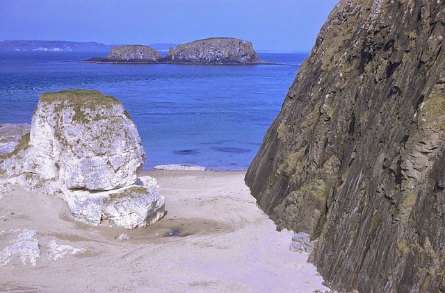
Just E. of Ballintoy Harbour, Co. Antrim. Looking E. Upper Chalk and Tertiary dolerite intrusions just east of Ballintoy Harbour, Co. Antrim. Intrusive plug of Bendoo on right-hand side with chalk stack in centre. Sheep Island still in centre middle distance with Rathlin Island on horizon. View facing east from small cave 200 yd. south-east of Ballintoy Harbour.
Old photograph number: NI00317
Port Reostin. Looking NE. Spaniard Rock and Chimney Tops. Five flows of dark-weathering Lower Basalts seen above sea level and below the Interbasaltic Bed which outcrop along the path. The overlying irregularly columnar lowest two flows of the Tholeiitic Basalts are seen to the right, the Chimney Tops being the columnar base of the second flow.
Date taken: 01/05/1959
Old photograph number: NI00290
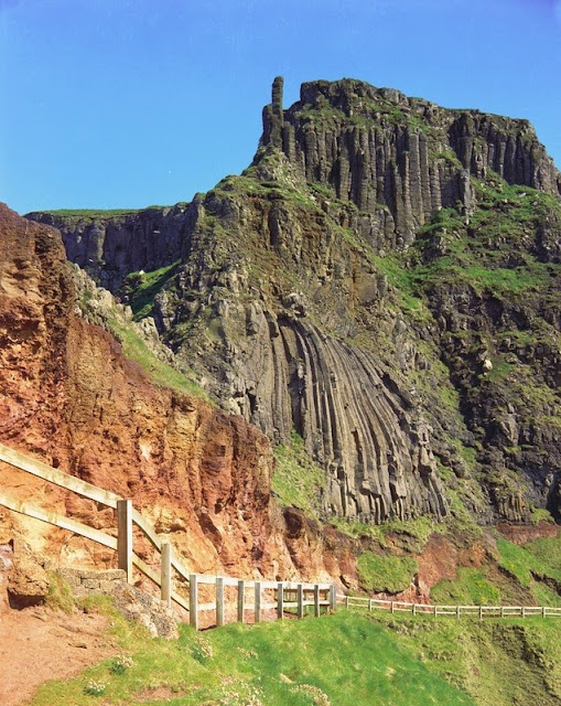
Irish Harp and Chimney Tops. Looking S. The footpath cut in the Interbasaltic Bed underlies the irregular columns of the first flow of the tholeiitic basalts. The isolated columns of the Chimney Tops are part of the second flow and a small part of the third flow is seen at the cliff top.
Date taken: 01/01/1969
Old photograph number: NI00712
Posted by Bob McIntosh
Geologists' Association Field Excursion to Leith Hill June 3rd 1912. Names of those listed:
C. Bromehead, Miss Cadmore, Miss Bassett, Miss Crosfield, A.C. Young, A Crosland (?), C. Candler (?). Dr. Bernstein, W. Watts, A. Gibbons. H. Lapworth.
From the Geologists' Association 'Carreck Archive' held at the British Geological Survey.
Posted by Bob McIntosh
Geological Survey of Scotland 1:10,560 Argyll Sheet 18. 1878 [eastern half added c.1933] The 'Clean Copy' deposited for public consultation.
While searching the old Survey geological maps of the Beinn Mheadhoin/Strontian area for information about mineral workings, Don Cameron, a BGS geologist, came across this handwritten note which seemed to be scurrilously referring to Edward Battersby Bailey (E.B.B.) the then Director of the Geological Survey of Great Britain. Further investigation by Marcus Mulcahy of the BGS Enquiries Team in Edinburgh unearthed the original fieldslip with an admission in Bailey’s handwriting that he mapped the area in question, noting: 'I know this part may be very badly mapped. I did it myself before I knew anything at all about gneiss rocks.' This matches the writing on the 'Clean Copy' above, so its likely that Bailey made the admission before the map was copied! The field slip is shown below.
Original fieldslip: Geological Survey of Scotland 1:10,560 Argyll Sheet 18 NE by 'R.C.B.J.' i.e. Robert Cyril Briscoe Jones with manuscript notes by Edward Battersby Bailey.
Note on the maps: A geologist would survey the area by taking a set of Ordnance Survey maps cut up for convenience in the field. The geologist would walk over the ground drawing in the geology he sees and making notes on the field slips and collecting rock samples for identification. In the evening during field days he would 'ink in' the lines he had surveyed. Much later, back in the office a 'Clean Copy' of the map would be made with the final interpretation and deposited in the Survey Library for consultation, the map would also be used when compiling the various published maps.
To learn about geological mapping in the early days of the Survey visit here.
Today, the process of mapping is all digital.
Posted by Don Cameron, Marcus Mulcahy, Gill Nixon and Bob McIntosh


