Sunday, 31 March 2013
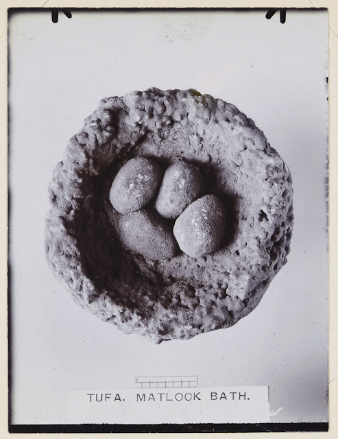
Tufa eggs for Easter, Matlock Bath, Derbyshire
Birds nest and eggs encrusted in tufa, Matlock Bath, Derbyshire. Photograph from the Geologists' Association 'Carreck Archive'
Original description: 'Tufa which also goes by the name of Travertin [Travertine] or Calcareous Sinter is a deposit of Carbonate of Lime thrown down by springs which flow through beds of limestone. In this case at Matlock these specimens are from lime obtained from the Carboniferous Limestone. The rain in passing through the atmosphere takes up Carbonic acid and assisted by humic acid from the soil when it sinks into the limestone dissolves portions of it away. When it comes to the surface again in the form of springs it loses some of the Carbonic acid and the lime is thrown down in the form of tufa and incrusting any object that happens to be present.'
T.W. Reader photograph album. Derbyshire, August 3rd 1914.
Bob McIntosh
Easter 1916, Bourton, Dorset. Geologists' Association Excursion.
Geologists' Association Excursion Easter 1916 - a page from a GA photograph album.
The image is a page from one of the many GA photograph albums now on deposit at the National Geological Records Centre, British Geological Survey and currently undergoing digitization and cataloguing. The GA 'Carreck Archive' is an amazing resource. It consists of a large number of photograph albums/scrapbooks and many loose photographs and ephemera relating to the GA excursions from the 1890s to the 1970s.
Unlike many other geological organizations of the time ‘Ladies’ were eligible for membership of the Association from its formation in 1858, and as a consequence, many of the early women geoscientists are represented in photographs and signatures. There was also no age limit so children were allowed to join, today a highly popular junior club called Rockwatch carries on this tradition.
Bob McIntosh
Saturday, 30 March 2013
Richard Cox Gough, 1826-1902, Proprietor of Gough's Cave, Somerset.
 |
| Richard Cox Gough |
A now partially faded photograph of Richard Cox Gough from the Geologists' Association Carreck Archive.
Gough was the cavern proprietor of Gough's Cave, a large and impressive stalactite/stalagmite filled cave in Cheddar, Somerset later also to become famous for 'Cheddar Man'. Genealogy information is available.
 |
| Signature of Richard Cox Gough - what a flourish! |
Friday, 29 March 2013
Raising a block of Portland Stone from the Seacombe Quarry, Worth Maltravers, Dorset
 |
| BGS image ID: P023962 |
Raising a block of Portland Stone from the Seacombe Quarry, Worth Matravers, Dorset. The block, cut from the face of the quarry by the plug and feathers method weighs about 4.5 tons. One of the advantages that the Portland Stone quarries have over other producers is the large size of the limestone blocks that can be produced. The limestone quarries of Portland Bill have been in operation since Roman times. The characteristic white limestones which have proved to be extremely durable, even in the most polluted of urban environments, can be found in important buildings in all major cities and most large towns in the United Kingdom.
The Isle of Purbeck, though perhaps more famous as the source of the fossiliferous Purbeck Marble, is also a major producer of Portland Stone. The same succession of worked beds - Basebed, Whitbed and Roach - that outcrop in the Isle of Portland extends into the Purbeck area. Many of the quarries in the Isle of Purbeck were sited along the coastal cliffs and the stone was worked via an extensive series of underground galleries.
BGS Old photograph number A4985
Date of photograph: 1930.
Photographer: J. Rhodes
Bob McIntosh
Thursday, 28 March 2013
Frank Perret, 1867-1943. 1936 Royal Society Montserrat Expedition.
 |
| BGS image ID: P536925 |
Frank Perret started out as a electrical engineer but later turned to volcanology spending 10 years studying Mount Pelée, Martinique from the start of the 1929-1932 eruption.
The image is from the The Archibald Gordon MacGregor Archive. In 1936 the Royal Society in collaboration with the Colonial Office organized an expedition to Montserrat to study the geology and investigate the earthquakes and soufrière activity that had caused damage in the previous two years. The personnel on the expedition were Dr C F Powell and Dr A G MacGregor.
Bob McIntosh
Wednesday, 27 March 2013
Fairy Glen, Rosemarkie Glen, Ross & Cromarty
 |
| BGS Image ID: P000471 |
The protective remains of soil and vegetation on the pillars was once continuous with that seen in background, and serves as an index to the amount of material removed by denudation. Once the protective cover is removed, erosion is rapid. Photographed about 1910 before the present-day tree cover was established. Glacial sands overlying boulder clay filling old valley and now being eroded by the present Rosemarkie Burn and by the direct action of rain, giving rise to earth pillars.
BGS Old photograph number: C01882
Bob McIntosh
Tuesday, 26 March 2013
Hercules and his fig leaf
This picture shows the fig leaf that used to be part of the statue of Hercules that is now at BGS Keyworth. The statue was installed in the Museum of Practical Geology in Jermyn Street , London in 1851. The story goes that the wife of the then Director of the Geological Survey and Museum, Archibald Geikie, objected to Hercules’s nudity. This resulted in the statue’s genitals being removed and a fig leaf being attached in 1883.
The genitals were stored in a velvet-lined mahogany box for over 90 years. In 1977 the genitals were reattached and the fig leaf was put in the mahogany box. In 1982 Hercules was moved to Keyworth.
Andrew L Morrison
 |
| BGS image ID: P807851 |
 |
| BGS image ID: P685329 |
 |
| BGS image ID: P808617 |
La Soufrière, St Vincent, 1902
This photograph captioned "East side of Soufrière, showing trees levelled by the blast" is part of an album of photographs of La Soufrière and Mount Pelée taken by Tempest Anderson.
Anderson was born in 1846 at York and was educated at St Peter’s School, York and University College London. He qualified as an ophthalmic surgeon and was for a time a consultant at York County Hospital. In his spare time he did a lot of travelling and was especially interested in visiting and photographing active volcanoes. In 1902 he was part of the Royal Society expedition to St Vincent and Martinique to study La Soufrière and Pelée. Anderson died on 26 August 1913 on his way back from an expedition to the volcanoes of Indonesia and the Philippines.
Andrew L Morrison
 |
| BGS image ID: P730640 |
Anderson was born in 1846 at York and was educated at St Peter’s School, York and University College London. He qualified as an ophthalmic surgeon and was for a time a consultant at York County Hospital. In his spare time he did a lot of travelling and was especially interested in visiting and photographing active volcanoes. In 1902 he was part of the Royal Society expedition to St Vincent and Martinique to study La Soufrière and Pelée. Anderson died on 26 August 1913 on his way back from an expedition to the volcanoes of Indonesia and the Philippines.
Andrew L Morrison
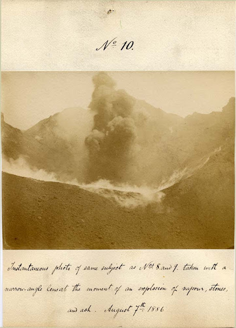
Vesuvius eruption August 7th 1886 by H.J. Johnston-Lavis
 |
| BGS image ID: P640525 |
Description below image reads: Instantaneous photo of same subject as Nos 8 and 9. taken with a narrow-angle lens at the moment of an explosion of vapour, stones and ash. August 7th 1886.
Johnston Lavis was born in 1856 and died in 1914. Educated at University College, London, he was Professor of Volcanology at the Royal University of Naples. He produced a map of Vesuvius in 1891.
Bob McIntosh
Monday, 25 March 2013
Kemnay Quarries. Aberdeenshire. Sett-makers working in their individual huts, locally called scathies.
 |
| BGS image ID: P000135 |
Original BGS photograph number: C3759
Photographer: W.D. Fisher
Date of photograph 1939
Sunday, 24 March 2013
Steam traction engine pulling 10 ton blocks of Portland Stone
 |
| BGS image ID: P023972 |
Photographer: Rhodes, J.
Date of photograph: 1930.
R.P. McIntosh
Saturday, 23 March 2013
Geological Survey of Scotland staff on the steps of Sherriff Court, Edinburgh
Early group photograph, Geological Survey of Scotland staff, from left to right H. Miller, B.N.
Peach, W. Gunn, L.W. Hinxman, [Unknown] sitting on steps, unknown.
Later group photograph of eight Geological Survey of Scotland staff including H. Miller, L.W. Hinxman, B.N. Peach, J. Horne and J. Dakyns.
These two photographs were taken on the steps of Sherriff Court in Edinburgh, the home to the Geological Survey of Scotland between 1879 and 1906. Perhaps these two pictures were taken on those two dates. The third photograph: The other residents!
 |
| BGS image ID: P008688 |
 |
| BGS image ID: P008720 |
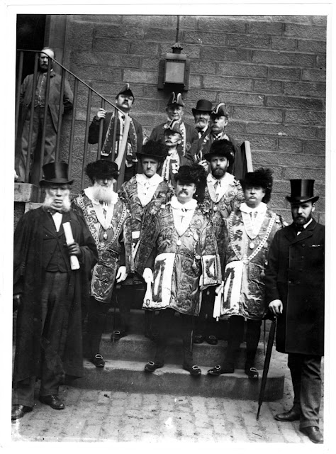
These two photographs were taken on the steps of Sherriff Court in Edinburgh, the home to the Geological Survey of Scotland between 1879 and 1906. Perhaps these two pictures were taken on those two dates. The third photograph: The other residents!
 |
| BGS image ID: P008690 |
Sharing the offices with the Geological Survey at Sherriff Court, Edinburgh were the Sherriff's attendants in full regalia - I wonder if this was everyday dress for them.
Bob McIntosh
Bob McIntosh
Friday, 22 March 2013
Arthur Smith Woodward's hammer
The label reads "This hammer was given to Sir Arthur Smith Woodward by an admirer and used at Piltdown and elsewhere, as for instance in Spain, but not in earlier work."
Smith Woodward (1864-1944) joined the Department of Geology at the Natural History Museum in 1882. He became Assistant Keeper of Geology in 1892, and Keeper in 1901. He began excavating at Piltdown in 1912, a few months after Charles Dawson informed him of the first finds there. He continued digging at Piltdown for many years but found nothing after Dawson died in 1916.
A very detailed bibliography of the Piltdown forgery is available to download here.
Andrew L Morrison
 |
| BGS image ID: P815509 |
Smith Woodward (1864-1944) joined the Department of Geology at the Natural History Museum in 1882. He became Assistant Keeper of Geology in 1892, and Keeper in 1901. He began excavating at Piltdown in 1912, a few months after Charles Dawson informed him of the first finds there. He continued digging at Piltdown for many years but found nothing after Dawson died in 1916.
A very detailed bibliography of the Piltdown forgery is available to download here.
Andrew L Morrison
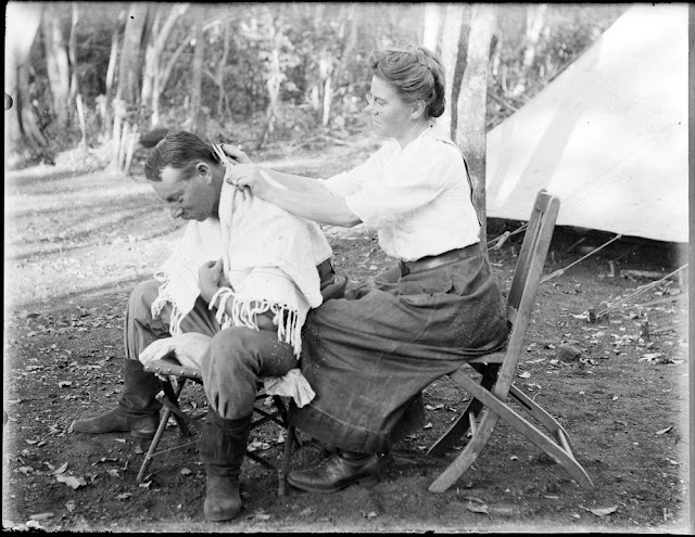
Time for a haircut. Edmund O. Teale.
 |
| BGS image ID: P776550 |
Edmund Teale's photograph collection
Teale's collection of Geoscenic
Bob McIntosh
Thursday, 21 March 2013
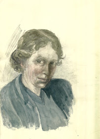
E M L Hendriks, self portrait
Eileen Mary Lind Hendriks was born in 1887. She graduated from the University of Aberystwyth in 1919 with a BSc, later completing a PhD at the University of London. Between 1926 and 1928 she was employed on a temporary basis by the Geological Survey to assist in the preparation of a catalogue of the Survey’s photographs.This was published as "Classified Geological Photographs: From the Collection of the Geological Survey of Great Britain" (1928). In 1930 Hendriks attempted to become the first female geologist at the Geological Survey when she applied for a permanent position. She was unsuccessful and found it difficult to find geological employment. Hendriks continued her geological research well into the 1970s, focussing primarily on the geology of Cornwall and Devon. She died in 1978.
Andrew L Morrison
 |
| BGS image ID: P815510 |
Andrew L Morrison
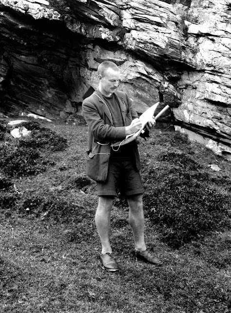
Edward Battersby Bailey as field geologist
 |
| BGS image ID: P225785 |
1902 Joined Geological Survey (Scotland). D.G. 1919.
1914-1918 Distinguished war service. Military Cross, Croix de Guerre with palms; Chevalier of the Legion d'Honneur.
1929 Survey Service terminated 24/12/29.
1929 Appointed to Chair of Geology at Glasgow in succession to J.W. Gregory. Elected Professor 12/12/29. Term began 1/1/30, lectures 6/1/30.
1930 Apponted F.R.S.
1937-1945 Bailey returns as Director of the Geological Survey of Great Britain.
1945 Knighted.
1965 Died 19th March.
Biographies and Obituaries
1930 Glasgow Herald 25/2/30.
1966 Obituary - Sir Edward Battersby Bailey. Born in 1881, died 19th March 1965. Proceedings of the Geologists Association. v. 77 p.157-159. 1966
1965 Richey, J.E. Obituary - Sir Edward Battersby Bailey, Kt.M.C., F.R.S. (Director of Geological Survey). Proceedings of the Geological Society. v. 1628 p.197-198. 1965
Bob McIntosh
Wednesday, 20 March 2013
Dune-bedding, Ballochmyle Quarry, Mauchline. Ayrshire.
 |
| BGS imageID: P000072 |
The view shows five quarrymen standing in front of the working face. The dune-bedding is composed of three large wedges, the bounding surfaces represent a time when the underlying dune was eroded prior to the deposition of the next dune. New Red Sandstone of Permian age. The dune-bedding is often seen in the polished faces of the stone in buildings, monuments and bridges throughout Ayrshire and Glasgow.
Date of Photograph: 1921. Photographer: W. Manson.
R.P. McIntosh
Tuesday, 19 March 2013
St. Paul's Quarry, Isle of Portland, Dorset.
 |
| BGS image ID: P023964 |
Stone has been worked on the Isle of Portland since ancient times for building and ornamental purposes. The commonly known Purbeck Marble is not a true marble but a polished fossiliferous limestone that contains the fossil shells of tiny water snails (the gastropod viviparus). The Purbeck rocks were deposited in the Jurassic and Cretaceous geological periods from about 155 to 45 million years ago. The quarrymen had their own terms for the various beds they came across. Rag stone, at the top was described as crumbly and very good; Grub, a fine bed able to produce fine paving stones and would take a polish; Roach, followed by Thornback would produce a 'blue hued stone'. At the base is the Freestone and above that the Whetson. The stone was both quarried and mined, both dangerous occupations. The limestone quarries of Portland Bill have been in operation since Roman times. The characteristic white limestones which have proved to be extremely durable, even in the most polluted of urban environments, can be found in important buildings in all major cities and most large towns in the United Kingdom.
Date of photograph: 1930. Photographer: Jack Rhodes. Original BGS photograph number: A4987.
Monday, 18 March 2013
Act of Parliament, 1845
This Act of Parliament was to "facilitate the completion of a Geological Survey of Great Britain and Ireland". It was passed 10 years after the Geological Survey had first come in to existence and put it on a much firmer footing. It is unlikely that the act's originators could have envisaged that the Survey would still be in existence 168 years later or the increased range of tasks that it would be involved in.
Andrew L Morrison
 |
| BGS image ID: P815508 |
Andrew L Morrison
Boskell China-clay Works, St. Austell. 1905.
 |
| BGS image ID: P200201 |
In the mid-18th century kaolin or China-clay was discovered at St. Austell. The extraction of China-clay, a form of decomposed granite used in the production of porcelain, became the mainstay local industry of St. Austell.
Photograph by: T.C. Hall. Date of photograph: 1905. Original BGS photograph number: A205.
Sunday, 17 March 2013
The 'Drum Rock', St. Mary's, Scilly Isles. Weathering of granite.
 |
| BGS image ID: P241718 |
Dated 1895. Entry in BAAS Report for 1903. Photographer: R.H.Preston, Alverne House, Penzance. Original format: Full plate. From the British Association for the Advancement of Science (BAAS) photographic print collection.
In 1888, a photographer, O.W. Jeffs proposed to the BAAS that they should address the need for systematic photographic coverage of the geology of the United Kingdom. His proposal was accepted and the BAAS set up a committee under the chairmanship of James Geikie, for the ‘collection, preservation and systematic registration of photographs of geological interest in the United Kingdom’. The collection soon expanded and was housed in London, first in the Geological Survey and Museum Library at Jermyn Street and later at the new premises in Exhibition Road, where it complemented the Survey's own collection of photographs. The BAAS committee arranged the sale of prints and lantern slides, and every year lists of photographs were published in the BAAS Transactions.
The collection at BGS consists of over 7,000 photographs from an original total of over 9,000. Most photographs covering Ireland are held at the Ulster Museum and a few albums, Dorset, Hampshire, and Lancashire, remain unaccounted for - does anyone know where they are?
Bob McIntosh
Saturday, 16 March 2013
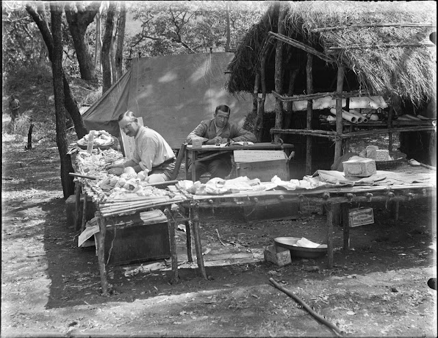
Geological survey team at work in the field camp. E.O. Teale photograph collection.
 |
| BGS image ID: P776542 |
Edmund Oswald Teale (formerly Thiele) Kt. Bach., D.Sc., F.G.S., F.R.G.S., M.Inst.M.M. 1874-1971.
Links:
Edmund Teale's photograph collection
Collection on Geoscenic
Bob McIntosh
Friday, 15 March 2013
Meteorological observatory and the Observatory Hotel, Ben Nevis
 |
| BGS image ID: P215988 |
Thursday, 14 March 2013
SILEX achates. Calcedony or Agate. From Sowerby's British Mineralogy. 1802-1817
 |
| BGS image ID: P705140 |
All the coloured plates from Sowerby's British Mineralogy have been scanned and are available on Geoscenic.
Bob McIntosh
Wednesday, 13 March 2013
The Bandits' Lair - the 'Desperadoes' of the Geological Survey of Scotland, 1885
 |
| BGS image ID: P008715 |
The 'Bandits' Lair' almost certainly dates from 1885, probably in the Spring of that year. Geikie instructed the newly recruited members of the Scottish staff that had been mapping in northern England previously to attend a 2-3 day trip/workshop in the NW Highlands with Peach and Horne. This is recorded in the Summary of Progress for 1885 and confirmed by Barrow notes on a later manuscript. Barrow, Clough, Dakyns, Gunn and Miller moved to the Scottish Office in 1884. Hinxman and Cadell were recruited in 1883. The photo was probably taken in Sutherland as they visited Loch Eriboll and the Scourie area. The two people missing are Dakyns and Cadell. It is suspected that Cadell was the photographer. The photo cannot be later as there is no recorded instance of the same body of people being in the field together subsequently. Also Linn became ill soon after and did little field work. [Text, John Mendum]
Bob McIntosh
Tuesday, 12 March 2013
Painting of the Museum of Practical Geology
This watercolour of the interior of the Museum of Practical Geology in Jermyn Street, London was painted by John Philipps Emslie in 1875. Emslie (1839-1913) was a topographical artist and folklorist. He studied at the Working Men's College in London where he was taught by, amongst others, Dante Gabriel Rosetti.
Andrew L Morrison
 |
| BGS image ID: P661605 |
Andrew L Morrison
Corncockle Quarry, Lochmaben. Dumfriesshire.
 |
| BGS image ID: P00100 |
Original BGS Photograph number:C3606. Date: 1937. Photographer: W.D. Fisher.
Bob McIntosh
Monday, 11 March 2013
Pumice from Krakatoa (Krakatau)
 |
| BGS sample: MR17778 |
Krakatoa (or more correctly Krakatau) is in the Sundra Strait between Java and Sumatra. The eruption of 1883 was one of the most violent volcanic events in recorded history.
In an interview in The Atlantic Monthly, Captain Watson who was in command of the "Charles Bal" recalled:
"At five the roaring noise continued and was increasing; darkness spread over the sky, and a hail of pumice stone fell on us, of which many pieces were of considerable size and quite warm. We were obliged to cover up the skylights to save the glass, while our feet and heads had to be protected with boots and sou-westers. About six the fall of larger stones ceased, but there continued a steady downpour of a smaller kind, most blinding to the eyes, and covering the deck to a depth of three or four inches very speedily”
Andrew L Morrison
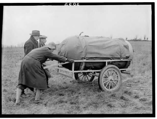
Early Tardis? Eötvos Torsion Balance, Drumchapel, Glasgow, c.1927
 |
| BGS image ID: P002454 |
A Eötvos Torsion Balance is a geophysical prospecting instrument that is used to determine distortions in the gravitational field, i.e. to detect local anomalies in the earth's gravitational field. These anomalies are due to concealed features, in this case undulations in the rock strata under a varying thickness of superficial glacial deposits. The torsion balance was being used to investigate the buried topography of the drift-filled pre-glacial Kelvin Valley. In total sixty-eight stations were investigated over three months in December 1927 and January-February 1928.
 |
| BGS image ID: P002455 |
Bob McIntosh
Sunday, 10 March 2013
Before fracking... original samples from the Scottish shale oil industry
 |
| BGS image ID: P528116 |
The shale oil industry started in Scotland in the 1850s reaching a peak in 1912 when 12,000 people worked in the industry. With the onset of the First World War and the importation of cheap oil from British interests in the Persian Gulf the industry saw rapid decline.
The image shows the steps from raw oil-shale fresh from the mine to a finished product - a packet of candles made from paraffin wax. The samples were sourced from the Pumpherston Oil Company Limited at Mid-Calder, a leading manufacturer in the Scottish shale oil industry.
Raw, black oil-shale (top left) was crushed and heated in a retort with injected steam to produce crude oil, this undergoes the first distillation to produce crude distillate (green oil). Top right, the spent oil shale. A second distillation of the green oil produced heavy oil containing paraffin. This was then separated into blue oil and crude solid paraffin. The latter paraffin wax in its unfinished state was refined and then manufactured into candles.
A full set of samples from each step in the process and the final products are held in the BGS collections in Edinburgh.
Bob McIntosh
Saturday, 9 March 2013
Our Special. Geologists' Association excursion to Hertford & Stevenage, May 2nd 1914
 |
| BGS image ID: P804680 |
Would travel arrangements like this for a field trip be allowed today?
Bob McIntosh
Friday, 8 March 2013
Shrapnel from bomb
This photograph shows shrapnel and other debris from a German bomb which damaged the Geological Museum at Exhibition Road, London at 11:47pm on 10 September 1940. Edward Bailey in his book Geological Survey of Great Britain records that the bomb "broke half the windows" and a later near miss in 1941 "completed out deglazing."
Andrew L Morrison
 |
| BGS image ID: P711014 |
Andrew L Morrison
Emily Dix, plant biostratigrapher (1904-1972) - Women's History Month
 |
| From Geologists' Association Carreck Archive. |
International Organization for Palaeobotany. Emily Dix (1904-1972). [Biography]
Bob McIntosh
Thursday, 7 March 2013
New Cook's Kitchen Shaft headgear, South Crofty Mine, Carn Brea, Cornwall
 |
| BGS image: P208023 |
New Cook's Kitchen Shaft headgear, South Crofty Mine, Carn Brea. Looking north-east, Cornwall.
South Crofty Mine headgear. Ore is hoisted by self-dumping skip to the ore bin, left of the headgear, waste rock is fed into trucks and conveyed to the dump (left in foreground). The pump, made in 1873, has an unequal beam (10 feet stroke in the cylinder and 9 feet in the shaft) and plungers are 20 feet diameter down to 1,150 feet below the surface. The shaft is 340 fms. deep. The headgear of Robinson's Shaft (335 fms. deep) is seen on the right. The Carn Brea area embraces the northern slopes of the Carn Brea granite and the thermally metamorphosed killas and greenstone that overlie the northern flank. Practically all fissures in the area have yielded copper in the upper levels with tin beneath to a proved depth of 2,500 feet. Date of image: 1945. BGS Old Photograph number A08101. Photographer: Jack Rhodes.
Bob McIntosh
Bob McIntosh
Wednesday, 6 March 2013
Portrait of Henry De la Beche
 |
| BGS image ID: P718393 |
Henry Thomas De la Beche was born on 10 February 1796. He spent much of his early life at Lyme Regis and developed an interest in geology. He was responsible for the creation of the Geological Survey (then called the Ordnance Geological Survey) in 1835 and he remained Director up to his death on 13 April 1855. He was knighted in 1848.
Andrew L Morrison
Prisoners of War building a 'steam navvy', Raasay ironstone mines
 |
| BGS image ID: P000048 |
Bob McIntosh
Tuesday, 5 March 2013
Exploratory oil drilling, D'Arcy, Midlothian. 1919-1922
 |
| BGS image ID: P000056 |
The boring commenced on the Carboniferous Lower Limestone Group which rises as a clearly defined anticline and which was believed to be favourable to oil accumulation. The boring is situated on the crest of this anticline. The boring produced gas at 724 feet (mainly a mixture of methane and ethane). This was sealed off. At 1810 feet some good quality oil was struck in a sandstone; the bore was stopped at 1820 feet. General view of oil well drilling rig, showing derrick and pile or casing against wall in foreground. A length of casing is suspended in the derrick by the travelling block. Photographer: D. Tait. BGS old photograph number: C02882.
For a short account of other notable and interesting boreholes in the UK visit the Geoscience Data Blog.
Bob McIntosh
Eruption of Etna, August 1892
 |
| BGS image: P711317 |
Presented by Professor G. Platania of Aci Reale, Sicily. Photograph held in the BGS Archives, Keyworth. Archive reference GSM/GX/Pa/1.
Bob McIntosh
Monday, 4 March 2013
Man power - Old Cleft Mine, Box, near Corsham Wiltshire
 |
| BGS Image: P539527 |
Hugh O'Neill was a Special Correspondent of the Quarry Managers Journal back in the 1960s and visited many of the active quarries in the UK and a few in Europe. His collection of over 3000 images is now on Geoscenic.
Bob McIntosh
Sunday, 3 March 2013
Mr and Mrs. Edmund Oswald Teale - at home in the bush
 |
| BGS Image: P776383 |
Edmund Oswald Teale (formerly Thiele) Kt. Bach., D.Sc., F.G.S., F.R.G.S., M.Inst.M.M. 1874-1971. Born, brought up and studied geology in Australia, Teale worked much of his life geological surveying in the Colonial Service in Tanganyika, East Africa. He was knighted on retirement to the UK in 1936. BGS has Teale's extensive archive of letters, diaries, field notebooks, a handwritten autobiography and many photographs. This image is probably from the 1920s.
Bob McIntosh
Bob McIntosh
Saturday, 2 March 2013
Scrablag
 |
| BGS image no: P804274 (not available on Geoscenic yet) |
Bob McIntosh
Friday, 1 March 2013
Museum of Practical Geology, Jermyn Street, first floor
 |
| BGS image: P640479 |
Bob McIntosh
